Concrete circles marking old airfields

Ed Haywood

En-Route
Joined
Jul 12, 2020
Messages
3,811
Location
Tampa FL
Display Name

Display name:
Big Ed
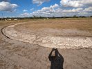
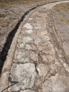
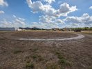
I am based at FD77, a private grass strip southeast of Tampa, FL. It was originally established as Wimauma Army Air Corps Auxiliary Airfield in 1938, and was used for fighter and bomber training during WWII.

Apparently old airfields in those days were marked with a large circle for visibility from the air. During some recent research, the current field operator noticed a circle in some pre-war aerial photos. He did some digging and found it!

Pretty cool, I say. If you are in the area, feel free to stop by and take a look. There is a Veterans day fly in tomorrow from noon to 5 that will include some more history of the field.
 

Attachments

  • PXL_20231110_185432133.jpg
    PXL_20231110_185432133.jpg
    5.1 MB · Views: 207
  • PXL_20231110_185414715.jpg
    PXL_20231110_185414715.jpg
    7.2 MB · Views: 205
  • PXL_20231110_185257261.jpg
    PXL_20231110_185257261.jpg
    4.1 MB · Views: 205
Last edited:
Usually, "did some digging" is a figure of speech. Here, it was literal. Took me a second to realize that!

Pretty cool find! I'd never heard of that before.
 
That resembles an old lighter than air tie down spot.

If there was a pole or remnants of a pole in the center of the circle then it might be an old tie down spot.
 
lol, looks like the ancient CDIs on my soon-to-be former airplane. Wonder what the ANP on that thing is, 10.0 miles maybe? :rofl:
About the same range of movement on some of the rental plane CDIs I've flown. :)
 
I'm an information junkie and have saved a number of links to "olde time" aviation navigation just in case I need them in my writing. Here are a few:

Guiding lights: (Airway beacons)

Concrete arrows:
 
Last edited:
Quite interesting, I do a lot of flying in the backcountry of Idaho. At Fish Lake there is a concrete circle, roughly mid field in the middle of the runway. I wonder if it was something like you have there?
 
If you look at some of the WW2 era airfields, you can see concrete circles. They were the reinforcement for the dirigible/airship touchdown area and circled the mooring mast.

Look at Houma, LA, Lakehurst,NJ and of course, Akron, OH.
 
Nobody caught the period-correct aircraft in the 3rd pic. Here is a closer look.
View attachment 122304
My father taught students in all three of those. BT-13s could be purchased as surplus after the war. Hometown man got one and converted it to a four seater. Unfortunately he killed himself and his family in it.
 
In the 30s many early fields were just circular or roughly square and pilots simply landed into the wind at all times. Have a book somewhere from around 1935 that lists "all" the airfields in the country by city - there are notes if one CANNOT land in any direction and also sometimes that the open field is traversed also by cindered or (imagine!) paved runways. But it's clear that those improvements are for the convenience of the larger aircraft beginning to operate at the time and not a limitation to using whatever part of the field needed in the direction required. See also for example mile-square field outside Pensacola.
 
A friend of mine has a hobby of finding 4 course radio range installations. The towers are long gone, but the concrete bases will be around for a long time. Some of the buildings containing the radio equipment still exist, repurposed as storage.
 
In the 30s many early fields were just circular or roughly square and pilots simply landed into the wind at all times. Have a book somewhere from around 1935 that lists "all" the airfields in the country by city - there are notes if one CANNOT land in any direction and also sometimes that the open field is traversed also by cindered or (imagine!) paved runways. But it's clear that those improvements are for the convenience of the larger aircraft beginning to operate at the time and not a limitation to using whatever part of the field needed in the direction required. See also for example mile-square field outside Pensacola.

I am told the circles were originally placed in the center of such aerodromes to indicate they were airfields and not just random clearings.

Did some reading on the National Air Marking Program. Found this reference from 1929: https://www.adirondackalmanack.com/2016/05/aviation-history-north-country-pilots.html

"By the end of July, more than 3,000 communities nationwide had been marked, including Plattsburgh’s Mobodo Airport roof. Atop the nearby Lobdell block was an arrow aimed towards the airport. A large circle of white crushed stone, the official airfield insignia in the U. S., marked the ground near Mobodo’s runways."
 
I am based at FD77, a private grass strip southeast of Tampa, FL. It was originally established as Wimauma Army Air Corps Auxiliary Airfield in 1938, and was used for fighter and bomber training during WWII.

Apparently old airfields in those days were marked with a large circle for visibility from the air. During some recent research, the current field operator noticed a circle in some pre-war aerial photos. He did some digging and found it!

Pretty cool, I say. If you are in the area, feel free to stop by and take a look. There is a Veterans day fly in tomorrow from noon to 5 that will include some more history of the field.
Another type of circular concrete pavement found at some WWII airfields were what were known as "Dispersal Parking". The military found out the hard way that parking aircraft in nice neat rows
made them easy targets in case of enemy attack. One answer was to scatter the parking spots over a large area to (hopefully) lessen the damage. Santa Maria Airport in California was a WWII AAF
base, and some of the concrete parking spots can still be seen here and there. Take a look on Google Maps Satellite View:

There used to be more of them, but other uses (like farming) have encroached on the area over the years.

Dave
 
NAS Beeville had a gigantic round "runway" with a wind sock in the middle of it, so the cadets could always land into the wind. It is long gone now.

Marine Corps Outlying Field Mile Square (MCOLF) was named after Mile square farm, but it did have three runways and an apron that was nearly a square mile. The nearby Tustin MCAS was a helicopter base and also had blimp hangars, which are still there, despite all the surrounding land being developed into shopping malls.
 
Tustin MCAS was a helicopter base and also had blimp hangars, which are still there
 
Tustin MCAS was a helicopter base and also had blimp hangars, which are still there
www.avweb.com

Fire Destroys Historic Blimp Hangar - AVweb

Firefighters used water-dropping helicopters to try to quell a fire at one of two enormous blimp hangars in Tustin, California, but the historic structure couldn’t be saved. The massive building, 1,000 feet long, almost 200 feet tall and 300 feet wide, caught fire overnight and continued to burn...
www.avweb.com
www.avweb.com

In 1955 I was a Marine stationed at nearby El Toro. I had to go on top of one of those hangars to replace an antenna. It was a LONG way up and a LONG way down.
 

Attachments

  • 1712517854182.gif
    1712517854182.gif
    42 bytes · Views: 2
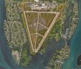
In Canada, WW2 brought about the Commonwealth Air Training Plan. There were many training bases built across the prairies, and the triangular runway layout was the thing. These are still seen from the air in many places; some no longer used as airports, a few that are. This is the one near Mossbank, Saskatchewan:

1712518890071.png

You can see the huge concrete slabs where the massive wooden hangars once stood. Just off the NW corner of the northermost hangar, just under the "ub" in "Club," is a gunnery target. The airplanes were propped up in flight attitude and the guns aligned with that target. Big concrete wall. This is it, now:

1712519087000.png

The Innisfail, Alberta airport is an active uncontrolled field popular with the sailplane and skydiver folks. It uses one remaining runway out of the triangle:

1712519517567.png

The Commonwealth Air Training Plan: https://en.wikipedia.org/wiki/British_Commonwealth_Air_Training_Plan

From the "Canadian Operations" part of that article:

At the plan's peak of activity in late 1943, the BCATP comprised over 100,000 administrative personnel operating 107 schools and 184 other supporting units at 231 locations all across Canada.

Infrastructure development including erecting "some 8,300 buildings of which 700 were hangars or of hangar-type construction." Fuel storage totalling more than 26 million imperial gallons (120,000 m3) was installed along with 300 miles (480 km) of water mains and a similar length of sewer mains laid, involving 2,000,000 cubic yards (1,500,000 m3) of excavation. A total of 100 sewage treatment and disposal plants and 120 water pumping stations were completed; and more than 2,000 miles (3,200 km) of main power lines and 535 miles (861 km) of underground electrical cable placed, servicing a total connected electrical power load of over 80,700 horsepower (60.2 MW).
 
Last edited:
Screenshot_20240407-160857.png
 
Another type of circular concrete pavement found at some WWII airfields were what were known as "Dispersal Parking". The military found out the hard way that parking aircraft in nice neat rows
made them easy targets in case of enemy attack. One answer was to scatter the parking spots over a large area to (hopefully) lessen the damage. Santa Maria Airport in California was a WWII AAF
base, and some of the concrete parking spots can still be seen here and there. Take a look on Google Maps Satellite View:

There used to be more of them, but other uses (like farming) have encroached on the area over the years.

Dave

Nice kart and autocross track :D
 
In Canada, WW@ brought about the Commonwealth Air Training Plan. There were many training bases built across the prairies, and the triangular runway layout was the thing. These are still seen from the air in many places; some no longer used as airports, a few that are. This is the one near Mossbank, Saskatchewan:

View attachment 127536

You can see the huge concrete slabs where the massive wooden hangars once stood. Just off the NW corner of the northermost hangar, just under the "ub" in "Club," is a gunnery target. The airplanes were propped up in flight attitude and the guns aligned with that target. Big concrete wall. This is it, now:

View attachment 127538

The Innisfail, Alberta airport is an active uncontrolled field popular with the sailplane and skydiver folks. It uses one remaining runway out of the triangle:

View attachment 127539

The Commonwealth Air Training Plan: https://en.wikipedia.org/wiki/British_Commonwealth_Air_Training_Plan

From the "Canadian Operations" part of that article:

At the plan's peak of activity in late 1943, the BCATP comprised over 100,000 administrative personnel operating 107 schools and 184 other supporting units at 231 locations all across Canada.

Infrastructure development including erecting "some 8,300 buildings of which 700 were hangars or of hangar-type construction." Fuel storage totalling more than 26 million imperial gallons (120,000 m3) was installed along with 300 miles (480 km) of water mains and a similar length of sewer mains laid, involving 2,000,000 cubic yards (1,500,000 m3) of excavation. A total of 100 sewage treatment and disposal plants and 120 water pumping stations were completed; and more than 2,000 miles (3,200 km) of main power lines and 535 miles (861 km) of underground electrical cable placed, servicing a total connected electrical power load of over 80,700 horsepower (60.2 MW).
I read a history book some years ago about the portion of the Empire Air Training Scheme which produced British aircrews in Canada and the US during WWII. It was a massive undertaking.
 
I am told the circles were originally placed in the center of such aerodromes to indicate they were airfields and not just random clearings.

Did some reading on the National Air Marking Program. Found this reference from 1929: https://www.adirondackalmanack.com/2016/05/aviation-history-north-country-pilots.html

"By the end of July, more than 3,000 communities nationwide had been marked, including Plattsburgh’s Mobodo Airport roof. Atop the nearby Lobdell block was an arrow aimed towards the airport. A large circle of white crushed stone, the official airfield insignia in the U. S., marked the ground near Mobodo’s runways."
This almost certainly explains why sectional charts depict grass strips as open circles.
 
On the U.S. Canada border in Michigan
 

Attachments

  • KONZ.jpg
    KONZ.jpg
    1.2 MB · Views: 32
That never occurred to me. Brilliant!
I've always wondered about it, particularly after I discovered that the earliest paved runways (actually landing pads more than runways) also looked like our sectional symbols:
 
In Canada, WW@ brought about the Commonwealth Air Training Plan. There were many training bases built across the prairies, and the triangular runway layout was the thing. These are still seen from the air in many places; some no longer used as airports, a few that are. This is the one near Mossbank, Saskatchewan: ...
Abbortsford International, BC still has all 3 runways, but only two are in use:
CYXX.GE.jpg
 
@Ed Haywood , you might enjoy this book:

Unfortunately Wimauma didn't make the book, nor did Winter Haven (the author seems to have overlooked the W's entirely). Nevertheless, it's got some great history and many photographs. Florida is so dotted with airports today thanks to the tremendous amount of WW2 training and development work that went on here. Good weather, lots of flat land, and lots of ocean surrounding the state made it an ideal location.

Cool, thanks!

We do have some of the history. Wimauma was an auxiliary airfield, a satellite training site for MacDill I believe. Supposedly British bomber pilots trained there. We have located a B17 crash site and a P51 crash site, both within a few miles, and are working on arranging an excavation.

The more "interesting" aspect of Wimauma history was during the 70's and 80's, when it's isolated rural character appealed to a different sort of Florida aviator.

Stop by sometime when you are drawing circles in the sky.
 
Stop by sometime when you are drawing circles in the sky.

I will. I know it's a private field; do I need permission to land?

I'm planeless for the next 6-8 weeks, in any event. I dropped off my baby Beech at the KBOW paint shop this morning.
 
I will. I know it's a private field; do I need permission to land?

I'm planeless for the next 6-8 weeks, in any event. I dropped off my baby Beech at the KBOW paint shop this morning.

No permission needed, visitors always welcome. Give me a heads up and I'll try to be around to show you some of the cool planes there. Congrats on the paint job!
 
i just watched a tv show talking about the old airfield in sebring, fl, and they mentioned their flagpole. it is surrounded by a white circle, and that made me think of the one at wimauma airpark. my father-in-law used to tie down his plane in front of the office in the middle of that circle. it was barely noticeable. i always thought it was a cool historical thing and should've been cleaned up and maintained.
 
Back
Top