francisco collazos
Pre-takeoff checklist
- Joined
- Jun 11, 2021
- Messages
- 412
- Display Name
Display name:
ciscovet
This is making the rounds on the internet. THey ended up with a low altitude alert from the tower then diverted to FLL
What makes the type of approach significant?Another RNAV approach. You would think they would get their act together after what happened in OKC.
Rain, turbulence, and winds are not an excuse for crossing the final approach fix 1,400 feet too low.It's not the type of approach, it's the heavy rain, moderate to heavy turbulence, gusty winds( possible wind shear) that makes it challenging.
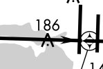
Should they be checking altitude periodically? What approach were they using? For example, if I read the chart (link below) properly, they should be no lower than 1600' crossing ZEXXY at 3.5 miles out.
Alerts? I wonder if the plane had an altimeter? How about this alert, “Captain execute the missed, we are too low”Once the gear and flaps are down, And a certain distance from the airport, the GPWS doesn't send all normal alerts. Southwest airplanes RA doesn't give 1000 ft and 500 ft calls, I believe.
“Captain execute the missed, we are too low”
I’ve been impressed with how hard you actually have to work to generate a GPWS callout.4.8 nm out, but yeah. Especially after the OKC incident.
I have to believe they would have been receiving all kinds of EGPWS alerts being that low that far from the runway, though. Along with just normal radar altimeter alerts like "500" "400" etc. - which should have seemed really out of place at 5 nm final.
Callouts, in addition to EGPWS, would have been;I have to believe they would have been receiving all kinds of EGPWS alerts being that low that far from the runway, though. Along with just normal radar altimeter alerts like "500" "400" etc. - which should have seemed really out of place at 5 nm final.
I’ve been impressed with how hard you actually have to work to generate a GPWS callout.
I give a bad altimeter in the sim that puts people 400 feet low on an approach, and it often only gives cautions by the time they get to the LNAV/VNAV DA.Granted I operate in an abnormal environment, but not a week goes by where I don't get a few EGPWS warnings during routine operations. Obviously I don't know the 737's implementation of various warnings, but I would think that being in a descent at 150 AGL at 5 nm from the runway would trigger SOME kind of alert.
I would hope SWA had gotten their act together after the 2014 KPLK wrong-airport incident…Another RNAV approach. You would think they would get their act together after what happened in OKC.
Yes, 4.8- thanks for the correction!4.8 nm out, but yeah. Especially after the OKC incident.
yup. If you really need an alarm to tell you you’re at 150 feet 5 miles from the airport you’re doing something wrong.I don’t get judgy about these things. But an observation…
Many here keep referring to an ALARM that should have warned them. This is straight procedural and situational awareness. No matter the conditions, this is a low level failure, likely enabled on by an over reliance on high technology.
Good procedure and situational awareness should have caught it, no matter the failure. It happens. It happens systemically, we go institutional to figure it out.
If you're in nasty weather, it's pretty dumb to do a visual approach, and this is the example that explains why.Interesting based on Juan's report it looks like they were lining up to land on the Cortney Campbell and in that case I imagine the decent countdown would have appeared to be normal. I wonder how often this stuff has happened in the past and only now where we have access to the data does it seem to be more frequent. The checks and balances did work as designed with the low altitude alert from the Tower.
Well, the bridge is pretty darn close to perfectly aligned to the approach course...... not sure you can say it that the alignment was due to using instruments.They were perfectly aligned with the final approach course, so it wasn't a purely visual approach. Automation mismanagement and lack of SA.
No, it isn't.Well, the bridge is pretty darn close to perfectly aligned to the approach course
Yes, I can. A human hand-flying a visual approach to a road isn't going to fly perfectly straight along the approach course for 5 miles in rain, thunderstorms, and windshear....... not sure you can say it that the alignment was due to using instruments.


Yeah, sounds as if someone saw what they expected to see: a runway-like visual.Short of auto-lands, all instrument approaches end in a visual segment. That's where mistakes can be made.
Jeez, visualizing that, it’s almost like they mistook ZEXYY for the MAWP. Note how the actual MAWP is buried in the middle of the airport in the planview. No “fletching” of a localizer to tip you off where that happens, either. No REIL or ALS on runway 10 either, just edge lights and a PAPI - doesn’t help distinguishing the runway environment a semi-aligned road.No, it isn't.
Yes, I can. A human hand-flying a visual approach to a road isn't going to fly perfectly straight along the approach course for 5 miles in rain, thunderstorms, and windshear.
View attachment 131610
View attachment 131609
And what would the needles be saying, for most of the last 5 miles?Short of auto-lands, all instrument approaches end in a visual segment. That's where mistakes can be made.
Jeez, visualizing that, it’s almost like they mistook ZEXYY for the MAWP. Note how the actual MAWP is buried in the middle of the airport in the planview. No “fletching” of a localizer to tip you off where that happens, either. No REIL or ALS on runway 10 either, just edge lights and a PAPI - doesn’t help distinguishing the runway environment a semi-aligned road.
I’m not saying there aren’t other major holes in the Swiss cheese, but I wouldn’t rule a chart misinterpretation out.
This is the latest one I have, dated 10/2020:I assume the flight crew was using Jepps, so the FAA depiction is likely not a factor.
Does anybody have the Jepp chart for this?

It's flown in LNAV and VNAV. My avatar shows the display. It would require ignoring the vertical path indicator once the "runway" was in sight.And what would the needles be saying, for most of the last 5 miles?
Very true.Runway 10/28 is rarely used by transport jets. This may have been their first time attempting to land on 10.
I assume the flight crew was using Jepps, so the FAA depiction is likely not a factor.
Not quite as bad as the NOS chart, but the MAWP is still buried.