Unverified

midlifeflyer

Touchdown! Greaser!
PoA Supporter
Joined
May 25, 2006
Messages
18,479
Location
KTTA, North Carolina
Display Name

Display name:
Fly
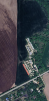
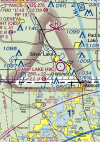
I’ve always been curious about this one. There is a Sectional chart symbol for a “unverified” airport. I was into this one years ago (2006). It used to be a fly-in “resort” in the middle of nowhere (the Runaway Inn, Joes, Colorado). The runway was downright nasty, part pavement, part broken pavement, part dirt. As I recall, back then, it wasn’t even on the Sectional.
1716648240694.png

The Chart User’s Guide has this description:
1716648329049.png

My question is, what gets a location like this listed? As opposed to, for example, not being listed at all. I have one possible speculation, but… Anybody know, preferably with an FAA reference?
 
I think they need to make it clearer. "Unverified" conjures up too many questions.
How about "Sketchy"?
 
How about ‘OBJECTIONABLE’? Southern Seaplane’s base. Even the water ‘runway’ is in bad shape. :biggrin:


View attachment 129136
That one has a reference that would allow one to look at criteria. “Objectionable” means there is some airspace-related problem (like being in the surface area of a military air station :D). It’s discussed in FAA Order 7400.2. That’s kind of what I’m looking for for “unverified.”
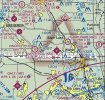
Not so much what it is, but why it gets charted. For comparison, the arrow is pointing to the location of a 2200’ turf runway connected to a restaurant. Not charted, not “objectionable,” not “unverified.” Nada.
1716654731886.png
 
That one has a reference that would allow one to look at criteria. “Objectionable” means there is some airspace-related problem (like being in the surface area of a military air station :D). It’s discussed in FAA Order 7400.2. That’s kind of what I’m looking for for “unverified.”
Not so much what it is, but why it gets charted. For comparison, the arrow is pointing to the location of a 2200’ turf runway connected to a restaurant. Not charted, not “objectionable,” not “unverified.” Nada.
View attachment 129138
I'd imagine in that case, someone didn't want to do the paperwork involved in getting it charted and just started mowing grass.
 
When do they ever remove an airfield?

Near to me, Chalet Suzanne was once a fancy restaurant ( https://en.wikipedia.org/wiki/Chalet_Suzanne ) with an airfield, but it's been closed now for about 10 years and the property is presently used as a drug addict rehab facility. The grass (and sand and weed and rock) airstrip is in disrepair and would be an appropriate landing site only in an emergency. I'm surprised it's still on the chart, and not even marked U.

Side Note - Back when I was still racing, it was a popular spot with some of the well-heeled drivers. Some folks would fly their own planes to Sebring for a race (having a shop trailer their racecar), and on Saturday evening they'd buzz up to Chalet Suzanne for dinner. It's less than a 15 minute flight from the Sebring airport.


1716663642204.png

1716663707644.png
 
Unverified is if the operator hasn't returned some FAA or state survey document.

Objectionable is if the airspace for the airport impinges on something like an approach , an airway or the airspace of another more important airport.
 
When do they ever remove an airfield?

Near to me, Chalet Suzanne was once a fancy restaurant ( https://en.wikipedia.org/wiki/Chalet_Suzanne ) with an airfield, but it's been closed now for about 10 years and the property is presently used as a drug addict rehab facility. The grass (and sand and weed and rock) airstrip is in disrepair and would be an appropriate landing site only in an emergency. I'm surprised it's still on the chart, and not even marked U.

Side Note - Back when I was still racing, it was a popular spot with some of the well-heeled drivers. Some folks would fly their own planes to Sebring for a race (having a shop trailer their racecar), and on Saturday evening they'd buzz up to Chalet Suzanne for dinner. It's less than a 15 minute flight from the Sebring airport.


View attachment 129140

View attachment 129141
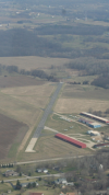
Westosha (5k6) closed about 6 years ago. Hangars are still there but runway was removed. Gravel pit bought it. Was notam closed shortly after and removed from sectional
 

Attachments

  • Screenshot_20240525-142537~2.png
    Screenshot_20240525-142537~2.png
    1.1 MB · Views: 14
  • Screenshot_20240525-143156.png
    Screenshot_20240525-143156.png
    3.4 MB · Views: 14
  • Airfields_WI_SE_htm_m41613a79.jpg
    Airfields_WI_SE_htm_m41613a79.jpg
    106 KB · Views: 13
  • Screenshot_20240525-142137.png
    Screenshot_20240525-142137.png
    2.3 MB · Views: 13
When do they ever remove an airfield
Right here used to be CO61, Yellow Hat/Golden Field, a private dirt strip near Gardner, CO. My User waypoint is pretty much the middle of the runway. I had friends who lived there.

Interestingly, it still in some databases. Here’s the entry still in SkyVector.

1716676446298.png
 
Last edited:
When do they ever remove an airfield?
Bellevue, WA (now a business park)
Issaquah, WA (now a shopping center)
Spanaway, WA (an automobile wrecking yard)
Two airports in Tacoma, WA. One near 19th and Mildred, another off 56th and South Tacoma way. I believe Charles Lindbergh landed at the latter one.

Blink a few times and another one will be gone
 
Unverified is if the operator hasn't returned some FAA or state survey document.
Reference?

I would think so, but then CO61 would be displayed but “unverified” rather than gone. The airstrip still shows in terrain maps. The Airport Manager listed in the SkyVector listing, passed away several years ago. The corporation that owns the airfield is in good standing, so I assume the residential airpark continues to operate.

And it doesn’t account for the one I used in my OP which I’m fairly certain was not charted at all when I flew there (definitely had no identifier) but now shows as “Unverified” with no other information.
 
Last edited:
Westosha (5k6) closed about 6 years ago. Hangars are still there but runway was removed. Gravel pit bought it. Was notam closed shortly after and removed from sectional
That’s where I learned to fly. And drove out there the day the airport closed along with a handful of others. Probably could have stayed open if the airport manager put a little bit more effort into running the place.
 
When do they ever remove an airfield?

Once the operator sends a airport registration form Form 7480-1 with the 'abandonment' box checked to the FAA.
 
Last edited:
No idea on the Unverified airfields.

I haven't looked, but are any of these closed fields in the Garmin / Jepp databases ? That makes me slightly worried that I mash "nearest" in an emergency and would be better off landing in a field. I do filter shorter and private strips.
 
I would think so, but then CO61 would be displayed but “unverified” rather than gone. The airstrip still shows in terrain maps. The Airport Manager listed in the SkyVector listing, passed away several years ago. The corporation that owns the airfield is in good standing, so I assume the residential airpark continues to operate.

The operator of a private field has the option not to have it charted. I believe it still shows up in the FAAs airport directory.
After you file an airport registration, at some point someone from state aeronautics shows up with a surveyors GPS in hand to walk the runway and get the coordinates for the thresholds.
Still hoping for a reference.
 
Still hoping for a reference.

It's what an owner of a 'unverified' farm strip in MN told me. Some mail went to Dad's mailbox in town rather than the current farm mailbox and things got lost.
State aeronautics came out to verify it's existence and it reappeared with the old identifier.
 
It's what an owner of a 'unverified' farm strip in MN told me. Some mail went to Dad's mailbox in town rather than the current farm mailbox and things got lost.
State aeronautics came out to verify it's existence and it reappeared with the old identifier.
Yeah, but I’m weird about wanting official references.
 
Here your go, from the Chart User's Guide:
1716648329049.png

So someone at some point informed the FAA there was an airport there, but the FAA doesn't currently have complete information.
 
Back
Top