The new Hudson River corridor

AuntPeggy

Final Approach
PoA Supporter
Joined
May 23, 2006
Messages
8,480
Location
Oklahoma
Display Name

Display name:
Namaste
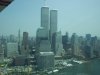
Last evening we attended a crowded meeting at the Crowne Plaza Hotel in White Plains to get briefed on the new operations for the Hudson River corridor. It seems that every effort has been made to incorporate as much as possible of the old rules into a no-nonsense safer set of rules.

First, the corridor is now split vertically into three corridors. The lowest one is for sight-seeing and "local" flights that will make altitude and speed changes and turns. The middle corridor is for "transient" aircraft that will maintain speed, altitude, and direction and fly the entire length of the Hudson River corridor from one end to the other. The top is for aircraft that want to maintain VFR contact with ATC (flight following).


So, from ground level to 999' helicopters and fixed wing aircraft have MANDATORY rules to follow. Notice that the rules are no longer voluntary.
  • mode C transponder
  • 2-way radio for CTAF
  • current NY TAC and/or Helicopter Route Chart in the aircraft with you
  • familiar with said chart
  • stay to the right of the river
  • max speed 140 kts
  • all exterior lights on (including landing light if so equipped)
  • self-announce on CTAF 123.05 mandatory checkpoints
    • Aircraft type
    • Position
      • Alpine Tower
      • GWB
      • Intrepid
      • Goldman Sachs
      • Statue of Liberty
      • VZ
    • Direction
    • Altitude
From 1000' to 1299' feet the same rules apply with the additional rules of maintaining
  • speed
  • direction
  • altitude
You may only transition between the "transient" altitudes and the "local" altitudes at the northern or southern ends (VZ or Alpine Tower)

There is also the VFR Transition Route, known as the "Skyline Route" from 1300' to 2000' where traffic is in contact with ATC and with Class B clearance. Northbound contact Newark Tower 127.85 prior to VZ bridge. Southbound contact LaGuardia Tower 126.05 prior to Alpine Tower. With initial contact, provide position, altitude, route name and direction.

Training is available on the FAA website.
 
Nice summary, Peggy. I'm flying up there on Saturday wx permitting. It will be interesting to see how often folks get denied the Class B Skyline Route.
 
No mention of increasing vigilance for other traffic, perhaps small turns and occasional leveling out from climbs/descents, having all on board helping spot traffic? (we are going to fix this with a series of regulations and restrictions, not with common sense?)
 
Thank goodness that FAA saved us from this horrific impending catastrophe. The airspace was so dangerous, there were just so many crashes.
 
So, who's going to be watching and punishing if you don't self announce at the George Washington Bridge?

Edit: Saw there was additional info below.
 
Last edited:
Thank goodness that FAA saved us from this horrific impending catastrophe. The airspace was so dangerous, there were just so many crashes.
It is dangerous airspace. It is estimated there were 225 aircraft operations per DAY in a 20 mile by 2 mile corridor that extended from 0' to 1100' AGL.

That there was only one mid-air collision in the 45 years since the corridor was first established, tells us that "increasing vigilance for other traffic, perhaps small turns and occasional leveling out from climbs/descents, having all on board helping spot traffic" has worked amazingly well.

My feeling is that the new rules make sense. The "Skyline Route" has always been there, albeit little known. Giving "through traffic" its own altitude is a great idea. Mandatory self-announcing changes common sense from a rule-of-thumb to a rule-of-law. One hopes that the amount of self-announcing on the frequency does not change. If it increases, then that simply reinforces the justification for making it required.
 
So, you think we can legislate away stupidity? Awesome.

And it is no more dangerous than any number of untowered, busy, GA airports. You've been sucked in by the hype.
 
Here's the problem Peggy:

There was no problem before (as evidenced by the lack of accidents). By legislating this, now, honest mistakes become less of a "I learned my lesson" and more of a "damn, I just lost my license and will have a hard time finding work as a pilot in the future."

Moreover, this legislation is going to cost money, and it shouldn't be necessary. I'm glad safety is on the brain, as that helps everyone, but I don't like to see legislation for the sake of legislation. This smacks as bad as closing the other corridor because Corey Lidle and his CFI don't understand that Bravo isn't a wall.
 
Geez guys, Peggy did not write the rules, she just has an opinion on them after attending a "seminar" to explain them. She did not get "sucked in" she is living with the new rules.

Thanks for the info Peggy. Flying the Hudson is in my aviation "bucket list".

My plan is to transmit "Any traffic in the area please advise." every 30 seconds ........! :yikes:


:rofl:
 
Last edited:
Thanks for sharing, Peggy!

It seems like a logical set of rules to me. When we were there this past summer, I didn't do the corridor flight b/c I didn't know the rules - was there anything published before these rules came out? JOOC - are the altitudes listed AGL or MSL?

As far as 'legislating common sense', unfortunately not everyone is 'blessed' with common sense like EVERYONE here on PoA seems to be. Some people need 'rules' to reduce the opportunity for them to exhibit their stupidity. It'll still happen, but at least there is a chance for them to get busted and 'weeded out' if they do so.

Above the Hudson River? Really? :eek:
 
Geez guys, Peggy did not write the rules, she just has an opinion on them after attending a "seminar" to explain them. She did not get "sucked in" she is living with the new rules.

Thanks for the info Peggy. Flying the Hudson is in my aviation bucket list.

My plan is to transmit "Any traffic in the area please advise." every 30 seconds ........! :yikes:


:rofl:

I'm not attacking Peggy. I'm discussing the merits of the FAA's actions with her, nothing more. She and I have a different opinion on it.
 
Hey.. If you're gonna legislate against stupidity, you gotta make sure you get all possible instances of stupidity.

Good point. 1000AGL, 1001MSL. Better put both altitudes on the charts!
 
Thanks for sharing, Peggy!

It seems like a logical set of rules to me. When we were there this past summer, I didn't do the corridor flight b/c I didn't know the rules - was there anything published before these rules came out?
Yes, the TAC and the Helicopter Route chart have always been available and were invaluable in flying the corridor. The good thing is that reporting points are specified and their accepted names will be printed on the charts.

There is also a CD available by Doug Stewart (he was at the meeting last night) that gives a great understanding of flying the corridor. I expect a new one shortly.

JOOC - are the altitudes listed AGL or MSL?
MSL. Since the Hudson River is actually an arm of the sea at Manhattan, MSL tends to be AGL as well. [Edit] Because of tides, the "ground" moves up and down about 10 feet every day.[/Edit]

You are expected to pick up ATIS from a nearby airport and adjust your altitude accordingly. There is no separate ATIS for the corridor, but there is usually little enough variation between the surrounding airports to keep you relatively safe. I say relatively because the "transient" layer is only 300' high. We all know of pilots who find maintaining altitude to that standard challenging.

As far as 'legislating common sense', unfortunately not everyone is 'blessed' with common sense like EVERYONE here on PoA seems to be. Some people need 'rules' to reduce the opportunity for them to exhibit their stupidity. It'll still happen, but at least there is a chance for them to get busted and 'weeded out' if they do so.
This is a whole other philosophical bag of worms that I'm not addressing here.
 
Last edited:
Here's the problem Peggy:

There was no problem before (as evidenced by the lack of accidents). By legislating this, now, honest mistakes become less of a "I learned my lesson" and more of a "damn, I just lost my license and will have a hard time finding work as a pilot in the future."

Moreover, this legislation is going to cost money, and it shouldn't be necessary. I'm glad safety is on the brain, as that helps everyone, but I don't like to see legislation for the sake of legislation. This smacks as bad as closing the other corridor because Corey Lidle and his CFI don't understand that Bravo isn't a wall.

By codifying what everyone was already doing, the FAA very cleverly appeared to be "doing something" WITHOUT making it FUBAR. Good for them, and good for us.
 
>self-announce on CTAF 123.05

dumb question: Is 123.05 sufficiently isolated so that you won't pick up
constant chatter from other areas? Unicom freqs around here in the
northeast are so close together that it's just constant squealing.
 
And to think I got these shots when I did:


09-02-2001

HR
 

Attachments

  • WTC#2.jpg
    WTC#2.jpg
    265.9 KB · Views: 37
  • WTC Twin Towers on Skyhawk.JPG
    WTC Twin Towers on Skyhawk.JPG
    94.1 KB · Views: 42
>self-announce on CTAF 123.05

dumb question: Is 123.05 sufficiently isolated so that you won't pick up
constant chatter from other areas? Unicom freqs around here in the
northeast are so close together that it's just constant squealing.

Good question: Two other airports using that frequency are about 60 miles away. The corridor CTAF frequency is already in use and there is not a real problem with interference.
KMMK - Meriden Markham Municipal Airport
and
1B1 - Columbia County Airport
 
By codifying what everyone was already doing, the FAA very cleverly appeared to be "doing something" WITHOUT making it FUBAR. Good for them, and good for us.
Well, not everyone, but everyone with a lick of sense. Good for the FAA on this one.
 
Other than the price of a NY Terminal Area Chart, what's the cost?
Tax dollars, primarily, plus whatever "educational" opportunities that the FAA takes to ensure that all pilots are familiar with the process.
 
IIRC, the only way to cross the GWB and stay below 1,000 was to cross mid span when travelling both directions. I always thought that bottle neck was the most dangerous location.
 
I tried to look up the rules as if I were going to fly right that area right after the accident and couldn't find anything official. There was a nice blog with recommendations that weren't required before, but nothing official I could easily find.

For those not able to attend the local briefing, is there a place these rules are clearly set out one can access if not from the area? Is there a notation on the terminal area chart that special rules apply and where those may be found?

Best,

Dave
 
Methinks there was confusion between TAC and WAC.
My mistake. I was thinking of the Helicopter Chart, which is an accepted substitute for the TAC.

The rule is effective on November 19, 2009. The FAA selected this date because there are three aeronautical charts that are affected by the modification to the New York Class B Airspace area. The new edition of both the New York Sectional Chart and the New York Terminal Area Chart is effective on November 19. These two charts are published every 6 months and the next edition would be May 2010. The effective date of the airspace modifications and the aeronautical charts must be consistent. If the rule is not effective on November 19, the airspace modifications could not become effective until mid-next year.

In addition, this rule requires a new edition of the New York Helicopter Route chart. While this particular chart is not on a regular update cycle as the terminal and aeronautical charts described above, it is republished only when significant changes occur. It is critical that this chart be updated and consistent with the terminal and aeronautical charts.

With reference to the cost of "educating" pilots...
The FAA is taking several additional actions to inform pilots of modified airspace over the Hudson River. An e-mail will be sent to all registered pilots advising of the final rule and available FAA training for operations in the New York Class B Airspace area. Postcards will be mailed to all pilots, for which there is no registered e-mail address. The FAA will conduct seminars and coordinate with other pilot groups to make users aware of the requirements specified in this rule.

 
I tried to look up the rules as if I were going to fly right that area right after the accident and couldn't find anything official. There was a nice blog with recommendations that weren't required before, but nothing official I could easily find.

For those not able to attend the local briefing, is there a place these rules are clearly set out one can access if not from the area? Is there a notation on the terminal area chart that special rules apply and where those may be found?

Best,

Dave

Get the TAC on Thursday.
Read the rule http://www.faa.gov/regulations_policies/rulemaking/recently_published/media/2009-27539_PI.pdf
 
IIRC, the only way to cross the GWB and stay below 1,000 was to cross mid span when travelling both directions. I always thought that bottle neck was the most dangerous location.
I believe the circle around the Statue is, and always has been, the most dangerous.

Your question came up at the meeting. There is an understanding that the GWB pillars rise more than 600' above the river. Stay to the right, not the center of the bridge, and stay inside the pillars. IOW, use good judgement in the future, just as you have in the past.
 
It clearly isn't that bad if this was the first accident in all those years. I've flown the cooridor, but always done so with flight following. Personally, I don't think doing otherwise is the best idea, but I don't see any reason to legislate otherwise.

Sadly, people feel they must mandate solutions to problems that don't exist.
 
Tax dollars, primarily, plus whatever "educational" opportunities that the FAA takes to ensure that all pilots are familiar with the process.
Well, I've got no issue with the FAA giving safety seminars on how to fly the Hudson Corridor safely, and never did, so no extra bucks there.
 
take the online course at FAAsafety.gov. It's nice, takes about 20 min, and you get WINGS credit.

Do a search in the learning center for HUDSON.
 
I tried to look up the rules as if I were going to fly right that area right after the accident and couldn't find anything official. There was a nice blog with recommendations that weren't required before, but nothing official I could easily find. For those not able to attend the local briefing, is there a place these rules are clearly set out one can access if not from the area?
Get a DUATS briefing for a flight anywhere within a couple of hundred miles of NYC and you'll get the NOTAM on it.
!FDC 9/3952 ZNY NY.. SPECIAL NOTICE.. HUDSON AND EAST RIVERS,
NEW YORK CITY, NEW YORK. DUE TO A HIGH DENSITY OF UNCONTROLLED
HELICOPTER AND FIXED WING TRAFFIC OPERATING ON THE HUDSON AND EAST
RIVER CLASS B EXCLUSION AREAS, PILOTS ARE ADVISED TO FOLLOW THE
GUIDELINES SET FORTH BELOW PRIOR TO ENTERING THIS AIRSPACE:
A. SELF ANNOUNCE ON 123.075 FOR THE EAST RIVER AND 123.05 FOR THE
HUDSON RIVER.
B. ANNOUNCE INTENDED ROUTE ON INITIAL CONTACT
C. TURN ON ANTI-COLLISION, POSITION/NAVIGATION, AND/OR LANDING
LIGHTS.
D. DO NOT EXCEED 140 KNOTS IAS.
THESE RECOMMENDATIONS DO NOT RELIEVE PILOTS OF COMPLIANCE WITH
APPLICABLE FEDERAL AVIATION REGULATIONS, INCLUDING REGULATIONS
GOVERNING MINIMUM SAFE ALTITUDES, AND SEE AND AVOID RESPONSIBILITIES.
PILOTS ARE STRONGLY ADVISED AND ENCOURAGED TO ADHERE TO THE
PROCEDURES SET FORTH IN THIS SPECIAL NOTICE AND ADHERE TO ALL
APPLICABLE FAA PUBLICATIONS, CHARTS AND COMMUNICATION PROTOCOLS WHILE
OPERATING IN THE NEW YORK AREA.
The reg itself has not, to my knowledge, yet been published.
 
I believe the circle around the Statue is, and always has been, the most dangerous.

Your question came up at the meeting. There is an understanding that the GWB pillars rise more than 600' above the river. Stay to the right, not the center of the bridge, and stay inside the pillars. IOW, use good judgement in the future, just as you have in the past.

Are you allowed to circle again? When I used to fly it years ago you could circle but I thought circling was banned following 9/11?
 
As far as I can tell, the new regs are just the old recommendations... very sensible rules, but if we consider last summer's midair, we see that none of these- whether guidelines or regs- would have prevented that tragedy, nor will they prevent a similar tragedy in the future.

But if it's enough to keep Chicken Little from clamoring to shut down the corrdior, I'll happily endorse these "changes". :rolleyes:
 
Are you allowed to circle again? When I used to fly it years ago you could circle but I thought circling was banned following 9/11?
You are allowed to circle. Loitering is a "no-no" over dams and power plants and such, but making a circle around the statue is ok.

Counterclockwise, please, and fixed wing should stay high as the helos are usually down around 500-600 feet. Beware of the newark shelf just west of the lady.
 
As far as I can tell, the new regs are just the old recommendations... very sensible rules, but if we consider last summer's midair, we see that none of these- whether guidelines or regs- would have prevented that tragedy, nor will they prevent a similar tragedy in the future.

But if it's enough to keep Chicken Little from clamoring to shut down the corrdior, I'll happily endorse these "changes". :rolleyes:
Actually, if these rules had been in effect, since the airplane was in contact with ATC, he would have been in the Skyline Route between 1300' and 2000'. The helicopter would have been in the local area, below 1000'. They would have missed each other by 300'.
 
Nice summary, Peggy. I'm flying up there on Saturday wx permitting. It will be interesting to see how often folks get denied the Class B Skyline Route.
A couple of controllers were there and they are aware of our problem of getting services. They will do their best to accommodate VFR traffic. Your best bet is to contact them as early as reasonable so they work you in. For example, the HPN tower controller suggested when leaving Westchester, contact departure (same frequency as ground) and get a squawk code. HPN Tower will release you early from their frequency so you can contact LGA before getting to the Alpine Tower.
 
Back
Top