Five members of Georgia family killed (Piper PA-46 crash)

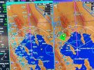
FYI, at 1800 UTC (the time of the accident) the Sidney (N23) AWOS was reporting heavy rain. Somehow, inexplicably, the accident aircraft apparently flew right into a scattered cell. During my IFR training (in the summer) I gained a tremendous respect for towering CU. Not CBs, just building CU with tops at 12000-14000 MSL. They can be a wild ride. Towering CU with moderate precip are definitely a no-go.

It was a weird weather day in Central NY. Some parts were severe clear, others had lines of scattered to isolated rain showers, some quite intense, due to a passing through of low pressure.
 
I have a sinking feeling many people put more faith in datalinked weather than they should.
Although there is no way you could have missed that towering CU unless you were in IMC. When there are isolated CBs and towering CU it is usually a good idea to stay below the bases or get above the lower tops so you can see and avoid the buildups. Of course, the best way to avoid the worst is to depart early in the morning (might not have been practical in this case due to activity commitments) or later in the evening when convection dies down.
 
The thing that caught my eye was the scalloping track of the aircraft on the initial clearance. It suggests that the AP was not engaged, and that the pilot was not tracking the GPS course well for some reason. With GPS and the AP engaged, the aircraft track is usually straight as an arrow. Looks like the aircraft may have either attempted a 180, or simply lost control in the cell, eventually emerging on an easterly heading before breaking up.
 
We wrongly assume the use of some or all WX tools. How do we even know if they got the departure ATIS, let alone anything else more critical for preflight, planning, and tactical maneuvering?
 
AC 00-24C recommends a minimum of 20 miles between you and any suspected thunderstorms. I really wish it was a legal requirement and not a recommendation.
 
Although there is no way you could have missed that towering CU unless you were in IMC. When there are isolated CBs and towering CU it is usually a good idea to stay below the bases or get above the lower tops so you can see and avoid the buildups. Of course, the best way to avoid the worst is to depart early in the morning (might not have been practical in this case due to activity commitments) or later in the evening when convection dies down.
I’ve found it interesting over the years what some pilots are willing to fly through that I’m not. Sometimes it’s just simply not paying attention to what’s going on in front of us.
 
Although there is no way you could have missed that towering CU unless you were in IMC. When there are isolated CBs and towering CU it is usually a good idea to stay below the bases or get above the lower tops so you can see and avoid the buildups. Of course, the best way to avoid the worst is to depart early in the morning (might not have been practical in this case due to activity commitments) or later in the evening when convection dies down.
Again, this was a smallish, but well-established cell in a group of other cells that tracked all the way across the state as part of a (cold) frontal passage. It wasn’t just a pop-up.

1 hour before departure, all the charts indicated this type of activity. There was a convective sigmet that encompassed that area:

AREA SEV TS MOV FROM 27020KT. TOPS TO FL450. HAIL TO 1.5 IN...WIND GUSTS TO 65KT POSS

There were also airmets for mountain obscuration.

The prog charts for 18Z clearly depicted the surface cold front just a few dozen miles to west. But the most obvious threat while still sitting in the FBO would have been identified by looking at the NEXRAD. That cell was very heavy as it passed Binghamton.

Here’s the picture at 1645Z, one hour prior to departure. The green arrow is the intended route of flight, the green circle showing the cell that they merged with:

IMG_3308.jpeg
 
Again, this was a smallish, but well-established cell in a group of other cells that tracked all the way across the state as part of a (cold) frontal passage. It wasn’t just a pop-up.

1 hour before departure, all the charts indicated this type of activity. There was a convective sigmet that encompassed that area:

AREA SEV TS MOV FROM 27020KT. TOPS TO FL450. HAIL TO 1.5 IN...WIND GUSTS TO 65KT POSS

There were also airmets for mountain obscuration.

The prog charts for 18Z clearly depicted the surface cold front just a few dozen miles to west. But the most obvious threat while still sitting in the FBO would have been identified by looking at the NEXRAD. That cell was very heavy as it passed Binghamton.

Here’s the picture at 1645Z, one hour prior to departure. The green arrow is the intended route of flight, the green circle showing the cell that they merged with:

View attachment 130903
Looking at the SIGMET and radar image, then contemplating the horror of the victims' death along with the unbearable suffering of surviving family gives rise to strong emotion, one being anger.
 
Lots of folks need reminding what that cold front moving into unstable air does.

When you're unsure of what the weather is doing, you can still make a phone call and have a briefer hopefully knock some sense into you.
 
Lots of folks need reminding what that cold front moving into unstable air does.

When you're unsure of what the weather is doing, you can still make a phone call and have a briefer hopefully knock some sense into you.

I’ll add that you can also reach out to FSS while airborne to help as well. I did this last Fall to help me determine what was going on around me based on what they were also seeing. I wanted to be quadruple-sure of what I was seeing outside, on ADSB, and stormscope. I was out of my home range and weather region experience. It was like talking to them on the phone.
 
I realize it’s a common refrain, latent radar information, ADS or XM. I still say, compared to any preflight briefing 1-2 hours prior, it’s very helpful. It’s often how the information is utilized, maybe never even a part of the chain.
I’d much rather have the ads weather available than not.
 
I realize it’s a common refrain, latent radar information, ADS or XM. I still say, compared to any preflight briefing 1-2 hours prior, it’s very helpful. It’s often how the information is utilized, maybe never even a part of the chain.
I’d much rather have the ads weather available than not.
Of course, but that is not the issue being considered. The use of ADSB for route planning in air close to CB is what is at issue. It is fantastic for planning while in the FBO or 100 mi out from systems. I also have no issue with using it while in VMC to get a bigger picture. I would never use it in IMC to avoid embedded storms.
 
A PA46 should have onboard radar… I wonder if it was used.
The aircraft has a bunch of different listings on Aircraft.com and each mentions a Sperry color radar. The panel has an older CRT for it as well. However, unless I’m missing something, I do not see a radome pod on or under the wings in any of the external photos. Could be that it was removed or added somewhere along the line?
 
The aircraft has a bunch of different listings on Aircraft.com and each mentions a Sperry color radar. The panel has an older CRT for it as well. However, unless I’m missing something, I do not see a radome pod on or under the wings in any of the external photos. Could be that it was removed or added somewhere along the line?
It supposedly was equipped with a WeatherScout radar mounted behind the leading edge in front of the spar. It was reportedly not a very effective radar in its time.
 
Just read the forecast discussion for the area just before they launched. A big NO THANK YOU for me. They made it 25 miles.

"Severe Thunderstorm Watch issued for Northeast PA and Sullivan County NY until 7 PM. Current severe line of storms has produced numerous damage reports, especially into Sullivan County/Roscoe area very recently"

 
Last edited:
Looking at the SIGMET and radar image, then contemplating the horror of the victims' death along with the unbearable suffering of surviving family gives rise to strong emotion, one being anger.

I don't want to admit to feeling the same way that you do but it's there. Looking at photos of the family that is now gone makes me extremely sad.

Perhaps the investigation will reveal a reason for this outcome that somehow makes this less heartbreaking ... but I don't see how that could be. It appears someone or perhaps more were complicit in making and following through on some very poor decisions ...
 
The paradox is that someone who is going to use the available tools prudently does not match the risk profile of this flight.

It’s like asking for advice; the people who need it most are least likely to ask or listen.
As the old adage goes. Advice. A wise man don’t need it and a fool won’t heed it.
 
AC 00-24C recommends a minimum of 20 miles between you and any suspected thunderstorms. I really wish it was a legal requirement and not a recommendation.

In Florida, most, if not all flying would be out of the question between March and October.

You would need 40 miles bewtween the storms to split two single cell thunderstorms.
 
Nexrad is pretty good for long range planning, but up close use abundant caution. As long as you FULLY understand that Nexrad will show stuff that is not there, will sometimes not show stuff that is there, and anytime that it shows stuff it is never completely accurate as to location and intensity, it is a useful tool Sometimes it is 3-5 minutes delayed, sometimes 20+ minutes, and the pilot has no way of really knowing. They time stamp is just reflective of the last data you received. Not how old the data is.

Another caution, when using ATC for vectors. They use the same time delayed radar outside of local approach control. Plus they often have filters on their feeds that block out weather at different altitudes and of different intensity. I have more than once had ATC try to vector me into a TS. Don't trust Nexrad for tactical weather avoidance. It is not the right tool.

Here was a good one, but I have dozens of these. This is a nice storm with tops in the 30's climbing out of the Salt Lake City valley. This area is served by 2 line of site Nexrad stations. Left panel is Nexrad showing a 2 min refresh. Right panel simultaneous onboard radar. Nothing on Nexrad. At night or in IMC would have no idea that cell was there.
 

Attachments

  • 1 (34).jpeg
    1 (34).jpeg
    439.8 KB · Views: 38
In Florida, most, if not all flying would be out of the question between March and October.

You would need 40 miles bewtween the storms to split two single cell thunderstorms.
Same in south Louisiana from June through August...but, I can go VFR between the cells. On those days that are IMC at the levels I would fly and CB popping up I would not rely on ADSB-in radar imagery to guide my way. Perhaps I suffer from hypogonadism :) .
 
A few things, I thought I read where this pilot operated with ‘basic med’ restrictions?


https://www.faa.gov/licenses_certificates/airmen_certification/basic_med

Also, he got his license about 10 years prior, then ended up flying this high performance plane. I didn’t see his total hours or experience, realizing, 10 years ‘could’ include a lot. Could it be a case of more airplane($$) than experience, as a contributing factor?
We all remember reading ‘The Killing Zone’.
 
Nexrad is pretty good for long range planning, but up close use abundant caution. As long as you FULLY understand that Nexrad will show stuff that is not there, will sometimes not show stuff that is there, and anytime that it shows stuff it is never completely accurate as to location and intensity, it is a useful tool Sometimes it is 3-5 minutes delayed, sometimes 20+ minutes, and the pilot has no way of really knowing. They time stamp is just reflective of the last data you received. Not how old the data is.

Another caution, when using ATC for vectors. They use the same time delayed radar outside of local approach control. Plus they often have filters on their feeds that block out weather at different altitudes and of different intensity. I have more than once had ATC try to vector me into a TS. Don't trust Nexrad for tactical weather avoidance. It is not the right tool.

Here was a good one, but I have dozens of these. This is a nice storm with tops in the 30's climbing out of the Salt Lake City valley. This area is served by 2 line of site Nexrad stations. Left panel is Nexrad showing a 2 min refresh. Right panel simultaneous onboard radar. Nothing on Nexrad. At night or in IMC would have no idea that cell was there.

Have to make sure you’re not just looking at the lowest scan tilt on the NEXRAD mosaic, too, as that can miss elevated storms, especially in their initial stages. But that region is known for dry microbursts and an elevated storm like that could absolutely produce one.
 
A few things, I thought I read where this pilot operated with ‘basic med’ restrictions?


https://www.faa.gov/licenses_certificates/airmen_certification/basic_med

Also, he got his license about 10 years prior, then ended up flying this high performance plane. I didn’t see his total hours or experience, realizing, 10 years ‘could’ include a lot. Could it be a case of more airplane($$) than experience, as a contributing factor?
We all remember reading ‘The Killing Zone’.
Even if he had basic med, The pa 46 is still an acceptable craft....provided he stays under 18,000'. It's less than 6,000 pounds, 6 people or less, and under 250kt (indicated) cruise.

This is a failure to understand weather or the limits of the plane.
 
In Florida, most, if not all AFTERNOON flying would be out of the question between March and October.

You would need 40 miles bewtween the storms to split two single cell thunderstorms.

FIFY, as a general rule the key is to fly early before the afternoon storms start to develop, or early evening after they start to dissipate.
 
Seems like this type accident is somewhat more prevalent among light turboprops like the M class and Pilatus. I have no data to that effect, but I do remember several similar accidents, including one particularly horrific story over Lakeland, FL that was almost identical.
 
All my years of Navy flying, did not go IMC in what was then a “Willy Willy” weather area. Sat and waited it out.
In my time flying C-130s we did not always have a choice. I experienced penetrating a line of thunderstorms and trying to figure out where we were when we came out the other side.
 
Seems like this type accident is somewhat more prevalent among light turboprops like the M class and Pilatus. I have no data to that effect, but I do remember several similar accidents, including one particularly horrific story over Lakeland, FL that was almost identical.
The 2019 South Dakota PC-12 crash that killed nine family members is the all time leader in this tragic category. Hubris and incompetence merged.
 
This accident profile is rather common, as is the reality of risk compensation, by socioeconomic proxy in the case of these airplane types.
 
I wonder a bit if the pilot was familiar with weather other than here. I just spent a week in Florida, used to go all the time, and storms just seem to pass through. Lines of storms sometimes, but usually breaks in the middle. Here in the Hudson Valley, and maybe to an extent down near the Catskills, weather can just "stick" sometimes. By that I mean storms for hours that don't move. No idea why, or if that's unusual. Anyway, maybe the PA-46 pilot thought there was a way around or between, and there just wasn't any.

Very sad story.
 
I went back and read about the Lakeland accident in 2012. Still makes me shudder. Guy with dollars but no sense bought a PC-12. Had 34 hours in type when he took the wife and 4 kids to the Bahamas. Returning home, he was getting vectors from ATC to avoid embedded cells over central FL when he lost control at 24K, dove 10,000 feet, and ripped his wings off. Fragments of the wings damaged the fuselage and caused his 13 year old son to be ejected. Time from structural failure to impact was about 60 seconds.

I've long since quit caring about pilots killing themselves with stupidity, but the kids as collateral damage always get to me.
 
Kids and spouses. It's really tough for a non-pilot to understand the risk that flying in weather can represent, when everyone has experienced commercial flights that seem to just ignore weather, and when they trust their partner to be responsible.
 
The 2019 South Dakota PC-12 crash that killed nine family members is the all time leader in this tragic category. Hubris and incompetence merged.
That was a bad one, but it was icing, not thunderstorms or in-flight breakup. But if we're talking dumb turboprop tricks, there was that other PC-12 in Montana, too...
 
I went back and read about the Lakeland accident in 2012. Still makes me shudder. Guy with dollars but no sense bought a PC-12. Had 34 hours in type when he took the wife and 4 kids to the Bahamas. Returning home, he was getting vectors from ATC to avoid embedded cells over central FL when he lost control at 24K, dove 10,000 feet, and ripped his wings off. Fragments of the wings damaged the fuselage and caused his 13 year old son to be ejected. Time from structural failure to impact was about 60 seconds.

I've long since quit caring about pilots killing themselves with stupidity, but the kids as collateral damage always get to me.

At first I thought you were referring to this one https://www.flyingmag.com/technique-accidents-ntsb-releases-report-pilatus-pc-12-crash/ , and had transposed digits (2012 vs 2021).

PC-12s seem to be a popular choice for family murder/suicides....
 
A few things, I thought I read where this pilot operated with ‘basic med’ restrictions?


https://www.faa.gov/licenses_certificates/airmen_certification/basic_med

Also, he got his license about 10 years prior, then ended up flying this high performance plane. I didn’t see his total hours or experience, realizing, 10 years ‘could’ include a lot. Could it be a case of more airplane($$) than experience, as a contributing factor?
We all remember reading ‘The Killing Zone’.
I didn't dig far enough to see whether the PIC was the 78 year old, or the younger guy. In any event, I live in the adjacent county and am very familiar with the area. A very strong line of storms moved through my area shortly before the reported time of the crash. In fact, the same afternoon a camper was killed by a microburst in the same county as this accident, so I'll be shocked if weather isn't determined to be the causative factor.

I learned my thunderstorm lesson very nearly the hard way, a number of years ago as a fairly new PP. I was VFR with my family on board, late at night, no moon, in the midwest, no instrument rating, weather far away on Nexrad, nothing out the window until I suddenly found myself in the middle of a thunderstorm and completely in IMC. I was only about 1500 AGL and a mile or so from a class C airport, where I'd already decided to stop for fuel. By some miracle, and the tower controller turning every light they had to the highest setting, I didn't lose control and was able to reacquire visual contact with the runway and land, but to this day, I shudder to think I could have easily taken out myself and my entire family like this guy did.
 
my understanding is the PA46 is very easy to overspeed and overstress the wings. They cruise well above Va and are very slick and hard to slow down so if you accidentally wandered into towering cumulus with some significant up/down drafts I can see how it would be easy to get fast and break the wings off.
 
Back
Top