Any feedback on my altimeter practice site?

KJ7RRV

Pre-Flight
Joined
Jul 16, 2023
Messages
40
Display Name

Display name:
KJ7RRV
Hello! I'm not sure if this is the right forum; please let me know if there's a different one where this would be more on-topic.

I wrote a simple program to practice reading analog altimeters: https://kj7rrv.com/altimeter-practice/

Does anyone have any suggestions for improvements?
 
Nice concept, but I don't think having to focus on the difference between 15,410 vs 15,420 is particularly useful to the way altimeters are used in flight.
 
Hello! I'm not sure if this is the right forum; please let me know if there's a different one where this would be more on-topic.

I wrote a simple program to practice reading analog altimeters: https://kj7rrv.com/altimeter-practice/

Does anyone have any suggestions for improvements?
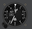
How do you use it. All I see is a picture of an altimeter.
 
How do you use it. All I see is a picture of an altimeter.
There's a text box below it. You read the altimeter, enter the altitude in the box, then hit Enter or click OK.
 
Nice concept, but I don't think having to focus on the difference between 15,410 vs 15,420 is particularly useful to the way altimeters are used in flight.
Do you think going in larger increments would help? Maybe 20 or 100 feet? It wouldn't be hard to make it configurable by the user.
 
There's a text box below it. You read the altimeter, enter the altitude in the box, then hit Enter or click OK.
I do that but nothing happens. What's strange is that if I close it and hit the link again in your op, post#1, a different altitude shows. Repeat that and a different altitude shows. It keeps opening with a random altitude with no correlation to what I entered.
 
I do that but nothing happens. What's strange is that if I close it and hit the link again in your op, post#1, a different altitude shows. Repeat that and a different altitude shows. It keeps opening with a random altitude with no correlation to what I entered.
You read the altitude it's showing. It picks a random one each time so you can't just memorize the altitudes it gives.
 
You read the altitude it's showing. It picks a random one each time so you can't just memorize the altitudes it gives.
Oh. So it's testing you to see if you read it right. I was thinking you'd enter an altitude and it would show you what it looks like.
 
Nice concept, but I don't think having to focus on the difference between 15,410 vs 15,420 is particularly useful to the way altimeters are used in flight.
Hey now, just because you got one wrong Mark... :D

I was wondering how accurate you had to be, like if there was some slop in the answers, but it seems pretty discrete 10 ft increments. Which I think is fine, after all, you're sitting on the ground, you should be able to tell the difference!
 
Oh. So it's testing you to see if you read it right. I was thinking you'd enter an altitude and it would show you what it looks like.
Exactly. It chooses a random altitude from 0 to 18,000 feet in ten foot increments, and you enter what it shows into the box.
Hey now, just because you got one wrong Mark... :D

I was wondering how accurate you had to be, like if there was some slop in the answers, but it seems pretty discrete 10 ft increments. Which I think is fine, after all, you're sitting on the ground, you should be able to tell the difference!
It does go in ten foot increments, and there is no margin of error allowed. I'm planning to add some settings to it; I'll add the ability to give some margin.
 
It does go in ten foot increments, and there is no margin of error allowed. I'm planning to add some settings to it; I'll add the ability to give some margin.
I don't think that's necessary or worth the effort - just add some instructions that say "enter the altitude shown (10 ft increments)" or something like that.
 
Exactly. It chooses a random altitude from 0 to 18,000 feet in ten foot increments, and you enter what it shows into the box.

You should include negative altitudes for those who fly out of TRM, BWC, Death Valley, and Israel! :D
 
You should include negative altitudes for those who fly out of TRM, BWC, and some airports in Israel! :D
Thanks for the suggestion! I am going to add that as well. So far that's my most popular feature request; someone on another site already mentioned that :)
 
I would be good to have the correct answer show up if someone gets it wrong. Training, not just testing.
 
Nice concept, but I don't think having to focus on the difference between 15,410 vs 15,420 is particularly useful to the way altimeters are used in flight.
I had the same thought. Hundreds is really the least-significant digit I care about when flying. When I look at the altimeter in the airplane I'm thinking, "I'm higher than 2,500ft, go down a little." I've never felt the urge to say, "I'm at 2,530 ft." I guess that would be useful for setting the altimeter on the ground without using local pressure.

And unless you wake up in IMC from a long nap in the pilot seat, context clues seem to be sufficient IRL for the difference between 2,500, 12,500, 22,500, etc.
I agree in most real life flying, BUT - this is obviously a training aid for someone at the very, very beginning of their aviation education. Somebody who has never seen an altimeter before. And they should learn what the small marks mean, so they know whether they are important or not. I mean, you need to KNOW something first before you can decide it's okay to ignore it.

And some checkride standards are +/- 50 feet, so it would be good to know where "50 ft" is. Plus, for instrument flight, MDAs on an instrument approach are rounded to 20 feet. And DAs are to the individual foot.

I don't think it's unreasonable to expect someone, especially sitting at a desk on the ground, to be able to tell me this altimeter says 570. If they said it was 560 or 580, or "about 600", or "500 and change", I wouldn't consider any of those to be a correct answer.

1689611520609.png
 
I would be good to have the correct answer show up if someone gets it wrong. Training, not just testing.
That's a good idea! I'll add it in my settings.

I'm sorry........."altimeter practice" ??
It's for practicing how to read altimeters.

I had the same thought. Hundreds is really the least-significant digit I care about when flying. When I look at the altimeter in the airplane I'm thinking, "I'm higher than 2,500ft, go down a little." I've never felt the urge to say, "I'm at 2,530 ft." I guess that would be useful for setting the altimeter on the ground without using local pressure.

And unless you wake up in IMC from a long nap in the pilot seat, context clues seem to be sufficient IRL for the difference between 2,500, 12,500, 22,500, etc.
I imagine it's harder to read an altimeter in a plane than on a computer or phone on the ground? It's quite feasible to read in 10 foot increments; I can do it quite reliably now after some practice on this.

I agree in most real life flying, BUT - this is obviously a training aid for someone at the very, very beginning of their aviation education. Somebody who has never seen an altimeter before. And they should learn what the small marks mean, so they know whether they are important or not. I mean, you need to KNOW something first before you can decide it's okay to ignore it.
Exactly. I wrote this because I was having a hard time reading the altimeter in my flight simulator (Piper Cherokee in FlightGear) and wanted a way to practice just the altimeter. While anyone is certainly welcome to use it, I doubt those who are already pilots would learn much if anything from using it. I just posted here to get feedback on it (which I definitely have, thank you everyone!), not because I thought it would be useful for already-certified pilots.
 
And some checkride standards are +/- 50 feet, so it would be good to know where "50 ft" is. Plus, for instrument flight, MDAs on an instrument approach are rounded to 20 feet. And DAs are to the individual foot.
If your concern on meeting the check ride standard is accurately reading the altimeter, rather than properly performing the maneuver, then I don't know what to think. Nevertheless, it's about the needle being in about the right place, no?

Likewise, if you're trying to read individual feet for a DA on that altimeter, you're doing it wrong.

JMHO of course.

Again, you have to know how to read it accurately before you can make decisions about under what conditions you don't need to read it accurately.

Reading an altimeter is not a hard skill. But it's a necessary skill. And like any skill, we need to be shown how to do it, correctly, and accurately.
 
Nice concept, but I don't think having to focus on the difference between 15,410 vs 15,420 is particularly useful to the way altimeters are used in flight.
If your concern on meeting the check ride standard is accurately reading the altimeter, rather than properly performing the maneuver, then I don't know what to think. Nevertheless, it's about the needle being in about the right place, no?

Likewise, if you're trying to read individual feet for a DA on that altimeter, you're doing it wrong.

JMHO of course.
In the new settings, you can set a margin for error.

You should include negative altitudes for those who fly out of TRM, BWC, Death Valley, and Israel! :D
You can change the min and max altitudes in settings now, and it does support negative altitudes.

I would be good to have the correct answer show up if someone gets it wrong. Training, not just testing.
That's also an option now.
 
When curious passengers ask, I tell them the altimeter reads like a clock. Most of the time, they get it immediately, no further explanation or examples needed.
 
Do you think going in larger increments would help? Maybe 20 or 100 feet? It wouldn't be hard to make it configurable by the user.
I think the small increments is the source of the priblem some have been having. i ran into the same issue. 20, which would show the altimeter on the lines would probably help a lot.
 
Does not work in safari. works fine in chrome on Mac.

Pretty funny, I've never found reading an altimeter difficult, but for some reason with this my brain just didn't want to engage and I kept getting it wrong.

Interesting app.
 
Does not work in safari. works fine in chrome on Mac.

Pretty funny, I've never found reading an altimeter difficult, but for some reason with this my brain just didn't want to engage and I kept getting it wrong.

Interesting app.
Unfortunately I don't have a Mac to test on. Could you please send a screenshot of what it does on Safari?
 
Unfortunately I don't have a Mac to test on. Could you please send a screenshot of what it does on Safari?
It's actually working now. sorry.
 
Back
Top