Sectionals for google Earth... Anybody know what happened to chartbundle?

Dana

En-Route
Joined
Oct 19, 2016
Messages
4,837
Location
CT & NY
Display Name

Display name:
Dana
Anybody know what happened to chartbundle.com? I've been using their sectional chart overlays for google earth for a while now, it was a great flight planning tool. But the other day they didn't come up, and the chartbundle.com website seems to have disappeared.

Or, anybody know of an alternative way to display sectionals in GE? I know I could download the charts in geotiff from the FAA and convert to kml, but that's a lot of work that I'd rather not do if there is a simpler solution.
 
I tried downloading some charts from that site maybe a month ago, and while the site came up, the charts did not download. So I suspect something is up.
 
Shut down due to a combination of too many outdated components on the system with security vulnerabilities and no time to fix and upgrade them all. Figured it was time to throw in the towel before something bad happened.
 
Bummer, but thanks for the explanation (and providing it while you did!), and understood. Got any suggestions for an alternative?
 
Bummer, but thanks for the explanation (and providing it while you did!), and understood. Got any suggestions for an alternative?
I don't know of anyone else doing the tile stuff. I've had a bit of interest in the code for the tile server so if anyone announces it I'll try and remember to mention it here.
 
I see that I can download sectionals in geotiff format from the FAA and import them into GE. Only issue is I get the borders and legends, which can sorta be gotten around if one turns them on in the right order. I recall at one point there was a way to import borderless charts. I'll have to poke around some more.
 
Very sorry to hear you are throwing in the towel. Did you know the FAA uses your Google earth files in their COA application Processing System (CAPS)? I request airspace for Unmanned aircraft operations and work inside the CAPS portal. Last week I was trying to enter a new application and the Sectional overlays are no longer there. Seems to have coincided with loosing the maps in Google earth. Your Maps were very useful and I could never quite get them stretched to match up, with the roads and such, as good as you did.
 
Very sorry to hear you are throwing in the towel. Did you know the FAA uses your Google earth files in their COA application Processing System (CAPS)? I request airspace for Unmanned aircraft operations and work inside the CAPS portal. Last week I was trying to enter a new application and the Sectional overlays are no longer there. Seems to have coincided with loosing the maps in Google earth. Your Maps were very useful and I could never quite get them stretched to match up, with the roads and such, as good as you did.
That's pretty funny the FAA were using them, since obviously that's where the data came from. Anyone who asked was told it was a hobby site and could just disappear at any moment, but I don't remember anyone from the FAA even asking.

Looks like the Google Earth files were converted using a script called "gdal_tiler.py" probably after being reprojected to EPSG:4326 Looks like that script came from here: https://sourceforge.net/projects/tilers-tools/

The code to do cropping and the web tile server is here: https://github.com/chartbundle/charts/ for anyone who wants to play with it, or attempt to.
I'm a contractor with the FAA and we've (FAA counterparts included) been using the chartbundle kmz overlays to aid in our analysis for a while now. You'd think that they would have something similar internal, but nope! Thanks for providing the cropping scripts, the individual maps are ok on their own, but the full CONUS together is much more useful. Attempting to spin up a docker image now, but admittedly I'm more of a Python dev and have never touched Perl! Thanks again for the service over the years!
 
Joined just to say thank you @chartbundle for providing this service, I have used it for years and miss it terribly for flight planning in my line of work. I didn't even realize it was just a hobby type thing! I bet you more people use it then you even realize.. even the FAA wow..

If anyone gets it back up and running it would be amazing..it takes me so much longer to try and use each map separately!
 
I joined to say thank you to @chartbundle because I have used your website a lot for my hobby flying. It is unfortunate that we, the users, were greedy and did not donate to keep the website up and running. I do not know what to say other than thank you!

To the reader who will read this in the future, I am a software engineer, and I can probably get the site up and running in 2 months. I currently work for one of the largest software companies here in America, and I have years of experience in making software. I was able to take a look at the source code that was posted, and it's old code that is #1 inefficient, #2 slow, and #3 insecure.

The unfortunate news is that if I manage to get this project up and running, it cannot be offered for free. I will probably charge $3 to $4 a month. The reason being is that if I start this project and keep it free, I will end up in the same place as Chartbundle and be shut down in a few years. Also, hosting the website costs money, allowing users to download large files also costs money. at this point everything costs money.

I will be back to check on this post on March 01, 2024. If I see that people are interested, I can probably start working on a backup site. Let me know what you guys think!
 
You’re going to get more folks at $25 a year plus a lot less hassle than billing per month. An add on to Google Earth isn’t going to be seen as something that is more than pocket change.
 
I signed up to add my 'thank you' to @chartbundle. As a software dev that provides various products at no cost, I can sympathize when the load gets too heavy.

Interestingly, NOAA provides ArcGIS MapServer layers for all the nautical charts. If you search on
NOAA charttools
you should be able to find that data.

Pity the FAA cannot do the same thing.
 
Thanks! Those FAA tiles work great. I am a software dev and one of my 'public service' projects is GISsurfer which is a general purpose web map with broad support for displaying GIS data. Right now I am making a GISsurfer map that will display the FAA tiles so they will be super easy for anyone to use.
 
Thanks! Those FAA tiles work great. I am a software dev and one of my 'public service' projects is GISsurfer which is a general purpose web map with broad support for displaying GIS data. Right now I am making a GISsurfer map that will display the FAA tiles so they will be super easy for anyone to use.
Reach out to globe.adsbexchange.com. They were using chartbundle tiles and now they're definitely having problems with their map data. Might be a nice business opportunity for you.
 
I sent the adsbexchange folks a link to FAA tiles. Assuming they see my message they will easily be able to switch over the the FAA tiles.
 
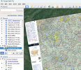
The GEO-TIFFs available from the FAA at https://www.faa.gov/air_traffic/flight_info/aeronav/digital_products/ can be imported into Google Earth and re-exported as (significantly smaller) KMZ files. A pain manually especially if you want everything and update regularly. Plus they complete with the legends.
I've tried that. Unless I am doing something incorrectly, it's an almost impossible pain to get them scaled and located properly on the GE grid. If you know how, I'd love to know.
 
I just finished updating GISsurfer (web map) to display the FAA tiles. I don't think I can post a link so...
1. If you search for 'gissurfer' the first hit should be the home page.
2. Look just above the embedded map and click the link to "Open map full screen".
3. After the map opens, click Menu > Recreation maps
4. Scroll to the bottom of the popup and open the GISsurfer link that displays the FAA tiles.

When that map opens it displays the FAA sectionals as a basemap. To change basemaps, click the basemap button (next to the menu button). The FAA basemaps are at the end of the basemap list.

Different FAA tilesets display at different zoom levels. For info, click "Map tips" in the upper left corner and read the "Introduction".

To turn on geolocation (assuming you are using a mobile device) tap Menu > My location.
 
I've tried that. Unless I am doing something incorrectly, it's an almost impossible pain to get them scaled and located properly on the GE grid. If you know how, I'd love to know.
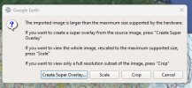
Dunno. I'm not doing anything special. When I import a Geo-TIF, I get the standard message about its size:
1707842490783.png

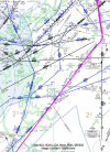
I select the default "Create Super Overlay." Here's a portion of an IFR flight from KLZH in NC to Allentown, PA. I chose this snip since I was following Victor and Tango Routes. The track log is from Foreflight. It's right on target. So is everything else along the route.

The only big issue is that the charts and legends overlap so depending on the route you may not see exactly what you want, but the geolocation seems fine.

1707844204160.png
 
I joined to say thank you to @chartbundle because I have used your website a lot for my hobby flying. It is unfortunate that we, the users, were greedy and did not donate to keep the website up and running. I do not know what to say other than thank you!
I actually took donations in the very beginning, I got enough to cover the direct expenses but dealing with it at tax time and the other tracking of funds made it not worth it. In the beginning it was more expensive as I had to pay the FAA for the DVD copies every cycle. Once they switched to downloads my direct cost was about $60/mo+ yearly domain registration.
 
I just finished updating GISsurfer (web map) to display the FAA tiles. I don't think I can post a link so...
1. If you search for 'gissurfer' the first hit should be the home page.
2. Look just above the embedded map and click the link to "Open map full screen".
3. After the map opens, click Menu > Recreation maps
4. Scroll to the bottom of the popup and open the GISsurfer link that displays the FAA tiles.

When that map opens it displays the FAA sectionals as a basemap. To change basemaps, click the basemap button (next to the menu button). The FAA basemaps are at the end of the basemap list.

Different FAA tilesets display at different zoom levels. For info, click "Map tips" in the upper left corner and read the "Introduction".

To turn on geolocation (assuming you are using a mobile device) tap Menu > My location.
Here's a direct link to where you'll get to if you follow those instructions:
 
Lots of ways to view sectional charts, but chartbundle overlaid the FAA tiles on Google Earth, which was very useful for trip planning (as opposed to just flight planning).
 
Lots of ways to view sectional charts, but chartbundle overlaid the FAA tiles on Google Earth, which was very useful for trip planning (as opposed to just flight planning).
The difference Between flight planning and trip planning?

But yeah, looking at a mostly static chart doesn’t do much. SkyVector does much more.
 
Dunno. I'm not doing anything special. When I import a Geo-TIF, I get the standard message about its size:
...

I select the default "Create Super Overlay." Here's a portion of an IFR flight from KLZH in NC to Allentown, PA. I chose this snip since I was following Victor and Tango Routes. The track log is from Foreflight. It's right on target. So is everything else along the route.

The only big issue is that the charts and legends overlap so depending on the route you may not see exactly what you want, but the geolocation seems fine. ...
Well, damn. It worked. Thanks. I can't tell you what I was doing wrong in the distant past.
 
The difference Between flight planning and trip planning?
The way I think of it is "flight planning" is planning the flight itself, airports, navigation, etc., whereas "trip planning" includes the above but also looking at what's along the way, food or lodging or interesting things near the airport and what the walk from the airport would be like, switch to satellite imagery to see what the enroute or destination terrain looks like, etc. I like hiking and camping, so sometimes I'll have parks and recreation areas overlaid on the sectional to look for interesting places to fly to. You can get that kind of mix on GE but not on, say, Skyvector.
 
The way I think of it is "flight planning" is planning the flight itself, airports, navigation, etc., whereas "trip planning" includes the above but also looking at what's along the way, food or lodging or interesting things near the airport and what the walk from the airport would be like, switch to satellite imagery to see what the enroute or destination terrain looks like, etc. I like hiking and camping, so sometimes I'll have parks and recreation areas overlaid on the sectional to look for interesting places to fly to. You can get that kind of mix on GE but not on, say, Skyvector.
Gotcha.

Good thing it's possible to do with the FAA's graphics.
 
chartbundle offered the maps in various formats. I used sqlite, which worked quite well for my purpose.
 
Back
Top