.25 to .30 mm is pretty far from the side of the runway for a PAR. Tolerance if on course should be within +- 30 ft from centerline. Hard to imagine your target was even touching the course line at that distance (safety limits wave off).
Not really sure how far off I was to be honest. I know I was over some commercial buildings and based on my best guess from the satellite view on google maps, I was somewhere around Katella Ave & Holder St when I should have been Katella Ave & Valley View St which is about 0.4 statue miles to the west. I could have been closer in but definitely no further in than Katella & Hope St as it took 20-30 degrees of correction to make it visually from my location to the runway so the math works out closer to Holder St.
They'll keep giving you course and glidepath and trend information after DH but it's all advisory in nature. Last call should be "over landing threshold,(course)."
Yes; if it wasn't clear from my post, from DH on was conducted visually (and of course, since the PAR is only available in VFR conditions, it was all conducted with a saftey pilot AKA my CFII in the right seat) and I was aware it was "advisory only" as the controller did slip in an "advisory only" warning both times. While the information was advisory, I was just surprised he continued since it was briefed with him we'd go missed at DA and I assumed they'd break off the approach at that point.
Since I wasnt assigned a minimum altitude restriction (aside from lacking clearance to land) and he continued to offer guidance, I continued to follow his guidance down almost to touch down but alas, wasn't authorized to land.
His last call was "crossing over threshold lights, (course)"
Are the approach plates for a PAR in the government or Jeppessen charts?
Radar approaches are not listed with the normal airport approaches they can however be found in the procedures section of the TERPS. Some civilian airports still have ASR approaches which stands for "Approach Surveillance Radar" which would also be listed in this section. An ASR is similar to a PAR but it lacks the vertical guidance and the lateral guidance is not as precise so it is a non-precision approach.
In the case of the Southern California TERPS (SW-3), there's 4 pages (N1 through N4) of Radar Minimums and all of the Radar approach procedures are for military bases and there are no civilian airports in the section as no civilian airport in the area operates a radar approach. If you wanted to land an ASR you'd have to go outside of SoCal and for a PAR you'd have to find a military airport that is open to the public; the closest to SoCal that meets this criteria is Yuma, AZ (KNYL) which is an MCAS airport (so it has a PAR) that also serves as a civilian public-access airport.
The PAR for Los Al (KSLI) is published on page N1 of the Southern California TERPS (SW-3).
The radar minimum procedure plate is not the most intuitive of plates nor is it very well explained and having not flown it before, I was reliant on ATC to tell me frequencies and who it was I was talking to because the approach plate, while listing frequencies doesn't really tell you what they are for.
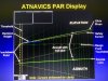
The other information on the page gives the different radar approaches available at KSLI, in my case, I did the RADAR 1 approach using the PAR with glideslope information for runway 22L. The approach has a 3.0 degree glideslope, a touchdown elevation of 40 feet and Runway Point of Intercept at 745.
For CAT ABCD, the DH/MDA-VIS is 282-3/4 which is 250 above touchdown.
In the case of Los Al, 124.75 is Ground Controlled Approach... They talk to you first getting you lined up and prepared for final (they remind you to do your landing check before handing you off) and you respond back to them like you would any other controller.
From GCA its over to 127.95 which is Final Control. Final Control does a "how do you hear" radio check and then from there they tell you not to acknowledge further tranmissions and the controller takes over. The Final Controller is required to give you feedback on where you are once every 5 seconds and a range from touchdown at least once per mile
The feedback consists of vertical and lateral position (Above/Below/On Glidepath and Left/Right/On Course) with a qualifier when off course (Well/Slightly/Drifting). When you are off course they'll also tell you how quickly you are converging or diverging from course with a "correcting/diverging slowly/rapidly"
I dont know what the tolerance is for "slowly" vs "rapidly" because all I ever got was correcting "slowly" but then I was puttering along at 90 and I imagine the tolerance is built for a much faster approach.
In my case, the controller also gave headings to fly and they expect you to fly those headings as it's how they calculate the next correction (so if they tell you fly 210 and you fly 200 your next correction may be off). You can do a "no gyro" approach in which case they wont give you headings instead telling you "turn left, stop turn, turn right, stop turn" and so on.
The PAR can get you down out of the soup with nothing more than a handheld radio. It takes some getting used to at first having to switch from interpreting "visual instruments" to interpreting "hearing sound" but its still surprisingly easy to do and I would have had no problem making the runway on either approach had I needed and been able to land...
Which brings up an important disclaimer to keep in mind... Normally you cant land at a military base so you cant file the base as an alternate (or your final landing destination) without permission to land that you are unlikely to get... That being said, in the event of an emergency or fuel exhaustion, a military field should not be passed over just because the controller said no. AOPA has a flight accident report/video in which an IFR pilot low on fuel was advised he could not land at the base and instead of declaring a fuel emergency ended up pushing the aircraft to fuel exhaustion, eventually crashing and getting himself killed. Military bases are valid fields in an emergency. You might have some explaining to do and it might be difficult to get fuel or your mechanic at the base but they are still no less valid than any other airport.
Here's a nice write-up from 2013 for the same KSLI approach.
http://www.wingsbywerntz.com/706-par-approach
Here's a video of the controller doing it in the SIM; its kind fo cool because you can see the new version of their screen and what it is they're looking at:
Here's another from ATC's point of view for a "live" approach in Iraq; kind of boring because the pilot was near perfect:
Of course, the computer imaged PAR with path tracing is new... The original machine looks like something straight out of a 1950's Sci-Fi movie.

")