Help me plan this flight

Chrisgoesflying

Cleared for Takeoff
PoA Supporter
Joined
Dec 7, 2018
Messages
1,367
Location
The Lone Star State
Display Name

Display name:
Chrisgoesflying
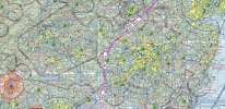
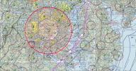
Next week, I'm planning to fly from BDR to Northwest Florida. Plane is a VFR only Piper Comanche. There is no ADS-B out on board so I have to avoid all Class C or higher airspace. Additionally, I obviously have to avoid that big, red circle over Washington DC. Right now, this is the route I have planned (see screenshots below). Any suggestions on different routing or anything major I'm missing?

1/3
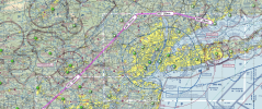
Screen Shot 2023-12-22 at 1.04.20 PM.png

2/3
Screen Shot 2023-12-22 at 1.06.35 PM.png

3/3
Screen Shot 2023-12-22 at 1.07.38 PM.png

And then once south of the DC area, it's pretty much a straight line to Florida.
 
You might consider scooting back southeast after you get around NYC, out to the Jersey shore and follow the coast down. Not all that much longer but a nice flight and stupid easy navigation even if you turned the GPS off.
 
I often wondered why you could fly under class C airspace but not over the top.……. I edited to add “not over the top”
 
Last edited:
Be careful of the Wilmington TFR when Sleepy Joe is home for the weekend.

Hopefully he'll be "working".

You might consider scooting back southeast after you get around NYC, out to the Jersey shore and follow the coast down. Not all that much longer but a nice flight and stupid easy navigation even if you turned the GPS off.

I'm considering that. I'll see how much time that adds. If it's not too much, we may do that. Edit: Just looking at it, if I do that, I would either have to go over water for a long(ish) time or go real low in order to avoid the ACY airspace without ADS-B :-(

I often wondered why you could fly under class C airspace but over the top.…….

I know, really stupid rule IMO.

Direct destination, turn on the autopilot, put a movie on the iPad, ignore the chaos outside the window...

Where do you put "direct destination" and what's that thing you call "autopilot"? lol. I have no GPS or autopilot on board. My GPS is my windshield, eyes and iPad and my autopilot is my trim and yoke.
 
If I was constrained by the equipment limitations you have, I would still like to travel high, probably no less than 6.5K but even 8.5k might be okay despite the often prevailing winds from the west to stay in smooth air and maximize TAS and gliding distance.

I could not go nonstop in my Archer but maybe you can in your Comanche, but lots of small airports to fuel or overnight.

To avoid most airspace complications my routing would be KBDR SAX BWZ FDK LDN KECP. I don’t know if the VORs are still functional but this routing will clear most complicating airspace requiring a slight wider berth north of NY Class B, a slight wider SE excursion to Allentown Class C, a tiny tiny NE deviation from Washington Class B, a very small SE deviation from Roanoke Class C. You would be barely clear of Charlotte Class B, and need a slight SE deviation at Greenville Spartanburg Class C, then straight through some MOAs which are hopefully not hot to KECP.

Overall, this is fairly straight after avoiding the NY airspace to the west. Hopefully, you have a GPS connected to your IPAD EFB to create waypoints for those slight deviations around the above airspaces, to give you a magenta guidance other than your eyeballs or VORs.
 
Last edited:
Good to start with a plan, but also be prepared for changes due to weather or other issues. I like to research airports along my route and note if there is gas, food, lodging nearby. I write this info down so I have it available in the plane. That way if a stop or divert is required I have options available, rather than trying to figure out something in the air.
 
This last post is good advice. Your backup plan may be as valuable as your primary plan.
 
If I was constrained by the equipment limitations you have, I would still like to travel high, probably no less than 6.5K but even 8.5k might be okay despite the often prevailing winds from the west to stay in smooth air and maximize TAS and gliding distance.

I could not go nonstop in my Archer but maybe you can in your Comanche, but lots of small airports to fuel or overnight.

To avoid most airspace complications my routing would be KBDR SAX BWZ FDK LDN KECP. I don’t know if the VORs are still functional but this routing will clear most complicating airspace requiring a slight wider berth north of NY Class B, a slight wider SE excursion to Allentown Class C, a tiny tiny NE deviation from Washington Class B, a very small SE deviation from Roanoke Class C. You would be barely clear of Charlotte Class B, and need a slight SE deviation at Greenville Spartanburg Class C, then straight through some MOAs which are hopefully not hot to KECP.

Overall, this is fairly straight after avoiding the NY airspace to the west. Hopefully, you have a GPS connected to your IPAD EFB to create waypoints for those slight deviations around the above airspaces, to give you a magenta guidance other than your eyeballs or VORs.

Thought about going further west, flying along the mountains but I figured that this route has fewer landing options in case it's needed due to the mountainous terrain and, if the wind is coming from the west or northwest (which likely will be the case), the ride may be bumpy, even at higher elevations. Also, I assume that if it isn't a severe clear day, I would be more likely to encounter low (relative to AGL) clouds closer to the mountains. Another routing I considered was to actually go so far west once leaving the NYC area that I'll be west of the mountains and then fly straight south, but that's a longer detour. I do have ADS-B in on iPad so I will be able to follow a magenta line, see traffic and weather.

Good to start with a plan, but also be prepared for changes due to weather or other issues. I like to research airports along my route and note if there is gas, food, lodging nearby. I write this info down so I have it available in the plane. That way if a stop or divert is required I have options available, rather than trying to figure out something in the air.

I usually do that as well. I've flown many long x-countries before, middle of Canada all the way down to Florida in a Cherokee and pretty much coast to coast in Canada. But this is the first time doing a long east coast cross country flight and the airspace is just so much busier and more complicated than the midwest.
 
Just looking at it, if I do that, I would either have to go over water for a long(ish) time or go real low in order to avoid the ACY airspace without ADS-B :-(
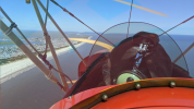
The ACY class C floor over the beach is 1300', plenty of room. Last time I flew past there I stayed at or below 1000' and about the same distance offshore.

1703289584977.png
 
The ACY class C floor over the beach is 1300', plenty of room. Last time I flew past there I stayed at or below 1000' and about the same distance offshore.

View attachment 123545

Anytime I'm below 3,000 feet, I don't really like it to be honest. I'm most comfortable between 5,000 and 10,000 ft. above the ground. I fly lower if ceilings need me to, obviously, but if I can avoid it, I will. Having said that, looking at it again, if I go to 5,000+ ft. even going over the ocean to avoid the class C, I would be within easy gliding distance to the airport if necessary so that route does start to be more intriguing.
 
Back
Top