Grand Canyon Day Trip - HIGHLY Recommended!

VWGhiaBob

Line Up and Wait
Joined
Mar 17, 2013
Messages
884
Display Name

Display name:
VWGhiaBob
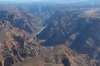
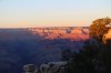
Finally found the right combo of good weather and time this weekend to visit KGCN from LA (KWHP). This was my most memorable trip ever at just about 2 hours in my Cirrus SR22 GTS! :yesnod:

Grand Canyon Airlines is the FBO there. They really took care of me with advise and a taxi service to Bright Angel Lodge, one of the most spetacular view points of the canyon...$6 each way. Fuel is high - $7.20, but hey, look where you are. Interestingly, there's a TSA security area, so you can't walk from transient to the FBO.

Airport is a little hard to see on the way in, but hang in there and it finally appears as a opening in otherwise green short pine trees and rocks. Runway is long...over 8,000 feet. I needed a surprising portion of it for takeoff at high density altitude, even in a Cirrus high performance with 3 passengers and full fuel (not quite gross, but close). Temperature was in the 50's, with an 18knot headwind right down the runway.

Winds are typically an issue at KGCN. I have checked from time to time on Foreflight...seems strong gusts are common, and frequently not straight down the runway. The local pilots told me they don't usually get bad until noon.

This was a "smooth" day for the flight back in the pm. Even so, we had a few "head ceiling bumpers". I'd say stay overnight if you can and some back in the am.

No, I didn't try the corridors yet. That's for next weekend! Love it so much, I'm going back.

(I will try to post pictures soon...big hassle to have to link to another site...and it's not working right now for some reason.)
 
Last edited:
Nice can't wait to see the pictures.
 
I did a few of the corridors a couple of weeks ago out of KLAS/KHND. Quite spectacular flying. A cool way to fly back to the LA area is to head down south towards Phoenix and then west towards San Diego.
 
Stop at the Sedona airport. Well worth the trip, the views of the red rock area are amazing.

Arizona_Trip_012__Medium_.jpg


Yes, I am lower than the ridge line when I took this. :D
 
Last edited:
I remember the first time I saw the canyon. Awe inspiring. Unfortunately it loses its appeal after flying the Black routes @ 8k and 9k a few hundred times. I hope I can appreciate it the same way again someday.
 
Here is a screen shot of the Grand Canyon corridors I platted on my 496.

Grand_Canyon_GPS__Medium_.jpg


Here's another shot of the Canyon

Arizona_Trip_023__Medium_.jpg
 
Last edited:
Here is a screen shot of the Grand Canyon corridors I platted on my 496.

Grand_Canyon_GPS__Medium_.jpg

How did you get this programmed in to your 530 or whatever you're using? I was thinking of using Foreflight plus visual, though I do have 2 430's. I have never programmed coordinates and hear it's not trivial.

Last thing I want is a deviation over GCN!
 
Do them as user waypoints. The GC VFR map has the coordinates. It is trivial on 430/530.

Also note that the Sanup flight free zone is below 8000ft so you can fly around there pretty freely.
 
Runway is long...over 8,000 feet. I needed a surprising portion of it for takeoff at high density altitude, even in a Cirrus high performance with 3 passengers and full fuel (not quite gross, but close). Temperature was in the 50's, with an 18knot headwind right down the runway.

Welcome to our high DA world, another good reason to check those performance charts, no matter what you fly!
 
Bob, I'm glad you enjoyed it, but please don't load to max at high DA.

You'll get away with it with no winds, but it leaves little margin. The rule of thumb is 10% under max gross above 5000 DA. That means one fewer adult than you're accustomed to.

Also identify an abort point prior to takeoff, and abort if you don't meet it. This protects against the common flatlander error of taking off full rich. With a really long runway, I'd suggest marking a taxiway or some other landmark where you want to be at least 50 AGL, and if you're not, land on remaining runway.
 
Last edited:
Interestingly, there's a TSA security area, so you can't walk from transient to the FBO.

SO how does this work? I've been into KMKL a couple times and they have an area in the terminal for passengers. But to go to the ramp you just walk thru a door to the FBO side of things.

Do you have to deal with TSA or prove you have a plane on the ramp at KGCN?
 
At GCN usually a van will pick you up at transient parking and drive you to the FBO, and do the same in reverse. However, you don't need to go to the FBO. You can walk out a gate by the parking area and get back in the same way if you remember to write down the combination. Can get more services in the passenger terminal; there isn't much at the FBO anyway.
Jon
 
Go to Mather point next time. Way better view than Bright Angel in my opinion....
 
SO how does this work? I've been into KMKL a couple times and they have an area in the terminal for passengers. But to go to the ramp you just walk thru a door to the FBO side of things.

Do you have to deal with TSA or prove you have a plane on the ramp at KGCN?
Just like many other small fields that have 121 service. Stay out of the box and you will be just fine.
 
What was the forecasted winds for 12000 feet?

Who cares? Just make sure you have enough fuel to make the nearest fuel stop which is not too far at all. Remember the saying..."90% of what you worry about never comes true, but that last 10% will kill you. Prioritize your worrying."

http://www.aviationweather.gov/adds/winds

:idea:

Your plane doesn't care about wind when flying. :no:


:rofl:
 
Last edited:
Who cares? Just make sure you have enough fuel to make the nearest fuel stop which is not too far at all. Remember the saying..."90% of what you worry about never comes true."


You will if you fly among the mountains in high winds, turbulence can make your life miserable.
He mention occasional turbulence so this is why I asked.
 
You will if you fly among the mountains in high winds, turbulence can make your life miserable.
He mention occasional turbulence so this is why I asked.

Been there, done that. Flying the corridors requires you be 10,000 -12,000' msl. That's roughly 2500' above the surface, and there are no moutains in the area. A little common sense will go a long way.

Why so negative? Why so worried about something that more than likely won't happen? Seriously, dude, don't sweat the small stuff.
 
Last edited:
How did you get this programmed in to your 530 or whatever you're using? I was thinking of using Foreflight plus visual, though I do have 2 430's. I have never programmed coordinates and hear it's not trivial.

Last thing I want is a deviation over GCN!

Why would a deviation be a big deal? Just announce your intentions, see & avoid, and go where you want to go. :dunno:

The corridors are the recommended / specificed ways to see the GC by small place. If you want to depart them at any point just do it safely. :dunno:

Attention POA, put your big boy pants on and plan a cross country trip. Get some experience and enjoy the flight! Its spring time and gas prices are low! Go for it!
 
Last edited:
Last edited:
Who cares? Just make sure you have enough fuel to make the nearest fuel stop which is not too far at all. Remember the saying..."90% of what you worry about never comes true, but that last 10% will kill you. Prioritize your worrying."

http://www.aviationweather.gov/adds/winds

:idea:

Your plane doesn't care about wind when flying. :no:


:rofl:

No, it was an entirely appropriate question for a high DA flight. High winds can force a descent when you least want it and make impressions of your ball cap in the top of your head.

This thread already describes two significant mistakes for conditions (afternoon flying and loading to max). He's checking for a third.

The OP had to get there from SoCal, and there are some significant mountains to cross.
 
Last edited:
Last edited:
No, it was an entirely appropriate question for a high DA flight. High winds can force a descent when you least want it and make impressions of your ball cap in the top of your head.

This thread already describes two significant mistakes for conditions (afternoon flying and loading to max). He's checking for a third.

The OP had to get there from SoCal, and there are some significant mountains to cross.

Yep, time to sell the plane, cancel the rental, it simply cannot be done in a small plane. Too dangerous, deadly flying conditions, thousands of aircraft lost every day over the Grand Canyon. They are thinking of filling it in to avoid the attaction . By all means don't listen to pilots who have actually flown the route over the GC from SoCal, south, east. :rolleyes2:

I must have been one lucky SOB. I've flown it 3 times. :rolleyes::rolleyes::rolleyes:
 
Last edited:
Yep, time to sell the plane, cancel the rental, it simply cannot be done in a small plane. Too dangerous, deadly flying conditions, thousands of aircraft lost every day over the Grand Canyon. They are thinking of filling it in to avoid the attaction .

I must have been one lucky SOB. I've flown it 3 times.

Jeez, I'll bet your passengers just have a grand old time with such careful attention to conditions.
 
Jeez, I'll bet your passengers just have a grand old time with such careful attention to conditions.

When losing an argument change the subject. Maybe you should try the spin zone. ;)

You missed the part where I said "use common sense". The "conditions" you are worrying about only exist in your imagination.

If you don't want to fly over the Grand Canyon don't! But please don't spread stupid rumors about turbulence and DA to scare off pilots who are looking for information. Common sense and good planning go a long way towards a very enjoyable GC flight.

If the flight is so dangerous and turbulent how do commercial operations make any money? They fly from Las Vegas dozens of times a day, all day?

Have you ever flown as PIC over the Grand Canyon?
 
Last edited:
Some time ago I was asking for tips on how to cross the Sierra from CA to NV, and the answers pretty much were "don't, you will die". and "you need O2, autopilot, turbine" and so on.

Ended up being perhaps the most enjoyable flying trip I've ever done.

Like Geico said. Common sense and good planning is what you need.
 
I flew it last November. We had a great time. Fueled up in Vegas KHND flew over Lake Mead and followed the cayon all the way to KGCN Grand Canyon South Rim. There was a small controlled Burn at the end of the runway. We stayed the night at the El Tovar Hotel. Got to see the sunset at the canyon. Great Fun!!!
 

Attachments

  • IMG_5005.jpg
    IMG_5005.jpg
    3.6 MB · Views: 44
  • IMG_5252.jpg
    IMG_5252.jpg
    3.2 MB · Views: 41
  • IMG_5292.jpg
    IMG_5292.jpg
    2.3 MB · Views: 40
  • IMG_5305.jpg
    IMG_5305.jpg
    2.3 MB · Views: 40
Bob, I'm glad you enjoyed it, but please don't load to max at high DA.

You'll get away with it with no winds, but it leaves little margin. The rule of thumb is 10% under max gross above 5000 DA. That means one fewer adult than you're accustomed to.

Also identify an abort point prior to takeoff, and abort if you don't meet it. This protects against the common flatlander error of taking off full rich. With a really long runway, I'd suggest marking a taxiway or some other landmark where you want to be at least 50 AGL, and if you're not, land on remaining runway.

Good advice. I did my calculations though (SR22 has high perforance engine) and was more than 10% under. The calcs showed ample room. I'm just used to the Cirrus' usual performance...with the light composite and big engine (550), sometimes it feels more like a helicopter. This time I had to wait and wait and wait.

My rule is take the POH number for high DA and double it for runway length.
 
Anyone have a good link with how to input waypoints? I'm told some math needs to be done...can't just input directly off Grand Canyon chart into 430. Can you tell I'm trying to avoid reading and trusting the 430 POH?
 
Anyone have a good link with how to input waypoints? I'm told some math needs to be done...can't just input directly off Grand Canyon chart into 430. Can you tell I'm trying to avoid reading and trusting the 430 POH?

You can create the way points by using the GPS coordinates from the map. Scroll to them on the screen and make a way point. It was easy on the 496.
 
Some time ago I was asking for tips on how to cross the Sierra from CA to NV, and the answers pretty much were "don't, you will die". and "you need O2, autopilot, turbine" and so on.

Ended up being perhaps the most enjoyable flying trip I've ever done.

Like Geico said. Common sense and good planning is what you need.

Exactly! Thank you! :yes:

I know people who have flown this route in a Cub. They didn't die, didn't use O2, and had a great time.

I flew from Lincoln, NE to Sata Rosa, CA in a LSA RV-12 (I built) in one day! Over the Rockies and Sierra mountains. Oh the humanity! It was a great trip! :yes:
 
Last edited:
Here is a screen shot of the Grand Canyon corridors I platted on my 496.

Grand_Canyon_GPS__Medium_.jpg

Watch out just blinding putting the VFR corridor end points into your GPS. You can clip the protected space just going from one to the other on the north rim side if you're at the minimum altitude allowed.
 
Watch out just blinding putting the VFR corridor end points into your GPS. You can clip the protected space just going from one to the other on the north rim side if you're at the minimum altitude allowed.

"Blindly putting". :dunno:

The coordinates come from the GC map. ;)

For those of you who actually wear big boy pants there is plenty of information on line to plane a successful and (believe it or not) safe tour of the Grand Canyon.

http://www.swaviator.com/html/issueJJ99/canyon.html
 
Last edited:
When losing an argument change the subject. Maybe you should try the spin zone. ;)

"Losing" an argument?

Only if past performance is an indicator of future returns, and if every new pilot is the crack fighter ace you are.

Yes, lots of people "have" done it. There is even a guy in Flagstaff with a 172M on the line. It still takes FAR more than "oh, just go." You simply must plan, and treating it like low altitude is NOT correct.

I have my share of mountain experience. What you seem to have missed is that the OP is a new pilot, flying at -- or really bit beyond -- the edge of his experience. MANY flatlanders in similar situations have died due to simple mistakes -- full rich takeoffs at Big Bear are a regular occurrence. Be responsible in your advice.

Oh, and I really don't care how big your body parts are.
 
Also identify an abort point prior to takeoff, and abort if you don't meet it. This protects against the common flatlander error of taking off full rich. With a really long runway, I'd suggest marking a taxiway or some other landmark where you want to be at least 50 AGL, and if you're not, land on remaining runway.

Quite possible the worst advice ever given on POA. :rolleyes2:

Lean for best power on the take off roll, or on run up. Watch airspeed and expect a longer roll. If you have not gotten enough speed for take off after 1/2 the runway is used up (small planes only) abort.

Do not take off and get to 50' AGL and then decide to abort the take off based on some arbitrary landmark you hope is accurate for your plane' performance. At 50' you are out of ground effect, in the air, climbing, and gaining speed. If you can climb 300'-500' /minute minimum you are good to go.
 
Last edited:
...So if you have an issue with the plane you cannot deviate from the corridors for any reason?...

No. In an emergency requiring immediate action, 91.3(b) trumps all other Part 91 regulations, including the Grand Canyon SFAR.
 
You can create the way points by using the GPS coordinates from the map. Scroll to them on the screen and make a way point. It was easy on the 496.

GNS430.jpg


Have you used a 430? Scroll to them? With what? the 430 doesn't have that cute little 4-way arrow button.
 
Anyone have a good link with how to input waypoints? I'm told some math needs to be done...can't just input directly off Grand Canyon chart into 430. Can you tell I'm trying to avoid reading and trusting the 430 POH?

When I did it, there was no math involved; I just had to be careful to enter the coordinates correctly. I don't remember which GPS model it was.
 
Back
Top