mtuomi
En-Route
No need to scroll anywhere, just enter the coordinates as user waypoints, job done.

Have you used a 430? Scroll to them? With what? the 430 doesn't have that cute little 4-way arrow button.
")
No need to scroll anywhere, just enter the coordinates as user waypoints, job done.

"Blindly putting".
The coordinates come from the GC map.


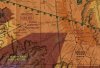
Have a look at the piece of the sectional that I have attached. Notice how if you draw a straight line from the left plus sign (north fossil canyon corridor) to the right plus sign (north dragon corridor) that it cuts across the purple area? Sure, you're only cutting that no fly area by a small amount but technically you are outside the VFR corridor.
Like I said be careful about just blindly connecting straight lines.
You're welcome
Anyone have a good link with how to input waypoints? I'm told some math needs to be done...can't just input directly off Grand Canyon chart into 430. Can you tell I'm trying to avoid reading and trusting the 430 POH?
Maybe you should check your facts before you claim I was flying in restricted airspace.
Have a look at the route I took. If you follow my route from the "Start" point heading east to west I was traveling SW down "Dragon Corridor" . I didn't draw a straight line to "Fossil Canyon". See the little magenta lines between the way points? You are suppose to follow them.
Maybe you should check your facts before you claim I was flying in restricted airspace.
I was making a generic comment warning against just connecting straight lines between those VFR corridor gates and gave an example. Don't be so defensive... Its a 9000 ft runway at 6500 feet. If the book says you can do it, do it. This nonsensical can't load the airplane to what the book says can be done mentality makes me chuckle.
Quite possible the worst advice ever given on POA.
If there is no wind, you're right.
Lots of bad things that aren't in the "book" happen when wind, terrain, and unequal heating mix.
The "book" for several common trainers also tells you to take off full rich. I really wouldn't recommend that.
Again, fly what's in the book. Are you saying the book doesn't have adjustments for winds? I mean, yes, be aware of the weather, but the terrain isn't that bad around there.
Again, fly what's in the book...
Remember, the OP is a new pilot, flying his airplane to high altitude for the first time. He doesn't know yet how his airplane should feel at that kind of altitude, what kinds of pitch angles he should expect, or even the proper technique for slow accelerations. You shouldn't tell him to die 'cause some critter made a home in his air box while he was away, just 'cause the book says he should make it.
Here's an example of what can happen when you combine believing the book at high density altitude with a basic configuration error (see if you can spot it -- most of the comments are wrong):
https://www.youtube.com/watch?v=yDu0jYiz-v8
Its a 9000 ft runway at 6500 feet. If the book says you can do it, do it. This nonsensical can't load the airplane to what the book says can be done mentality makes me chuckle.
He didn't claim that.
I wasn't claiming you were flying in restricted space


Get a canyon camouflage vinyl wrap and fly down at the river level.


You specifically said I put way points on the map "blindly".
I'm being defensive because you accused me of flying in the restricted area.
Nope. I did no such thing I warned against blindly putting in the points without checking the sectional. I'm starting to think maybe you did clip the airspace... I mean why else would you be so defensive and paranoid about this? It's okay... You're are surrounded by friends. Nobody will say anything. They'll say "oh just another elderly VFR only pilot a little confused and bumbling into areas he shouldn't be".
Seriously though I was just pointing out that you have to be careful connecting those end points. There was no accusation. Peace.

 , to share those pictures:


I'm in!
How about 400+ MPH?
https://www.youtube.com/watch?v=fqe6tzrOHoU
Density altitude my ass.
Double check the W&B!!!!!! I don't think so.
How about 600 MPH?
https://www.youtube.com/watch?v=2Z1Inn0Ro0A
I wonder if these guys were clipping the restricted space by drawing a straight line?
https://www.youtube.com/watch?v=h6yG-HO-8hQ
Seriously, after re-reading the pantie wastes posts in this thread worrying about this & that we should rename this forum ******* Of America.

At the risk of generating controversy, I decided that the corridors are too risky for me. Why?
Mainly because there's no "out" if you lose an engine there. After studying the terrain, I realized that unless you really get lucky, you're going down into the Canyon with an engine out. Even a Cirrus parachute is unlikely to help; if you don't roll down cliffs on the way, you could end up in the river.
")


A post mortem from the OP. On second thought, let's call it a follow-up.
Loved this trip so much that I did it again the next weekend and stayed overnight at the Cachina Lodge. Nothing like sunset and sunrise at GC!
At the risk of generating controversy, I decided that the corridors are too risky for me. Why?
Mainly because there's no "out" if you lose an engine there. After studying the terrain, I realized that unless you really get lucky, you're going down into the Canyon with an engine out. Even a Cirrus parachute is unlikely to help; if you don't roll down cliffs on the way, you could end up in the river.
The views from the El Tovar were priceless, including a 3 mile walk along the edge. For me, there's so need to assume the additional risk.
And regarding comments about calculations on runway roll...came out to 2,300 feet on a 9,000 foot runway. And reality matched that. Not dangerous at all, but interesting to feel (as I had done before in Big Bear) the amazing impact of DA.