Richard
Final Approach
- Joined
- Feb 27, 2005
- Messages
- 9,076
- Location
- West Coast Resistance
- Display Name
Display name:
Ack...city life
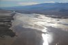
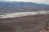
The Mojave River which flows north to empty into the remnant (usually a dry basin) of Lake Manly has been running at flood. And the worst of the series of storms hasn't impacted SoCal yet. I predict Manly will be an ephemeral lake this year. That also applies for the lake further to the north at Badwater. It will be a year for desert blossoms for sure.

")