Location reporting in magnetic or true?

ayryq

Filing Flight Plan
Joined
Apr 8, 2024
Messages
21
Display Name

Display name:
ayryq
I ran into this the other day and wondered what everyone thought. I live in area with +12° variation, which can make the difference between saying I'm "Northeast (or NNE) of the field" versus "North of the field" when making an initial call to ATC. Or perhaps on my chart I'm pretty clearly NE (true) of the airport (the course line is slanted!) but it's the 88° radial of the VOR at the airport I'm headed to.

I know it probably doesn't actually matter that much, but in some places with larger variations it could be a bigger difference. In one case I went with "north" and was told to make a left base to runway 14; when I corrected myself that I was in fact more "northwest" they changed me to a straight-in.

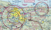
It should be based on magnetic, right? That's what I've got my HSI set to and how the runways are numbered.

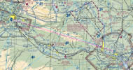
EDIT to add an example and image: imagine flying from YKM to PSC, your magnetic course is pretty close to 90°. Do you report to PSC tower "15 miles west of the field" or "...northwest..."?
 

Attachments

  • Screenshot - 2024-09-12 , 14_11_37.png
    Screenshot - 2024-09-12 , 14_11_37.png
    4.6 MB · Views: 21
Give them your magnetic heading or location in flight.

The runway and ground winds are reported in magnetic. Winds aloft are reported in true, which is why you have to adjust your calculated heading, after wind correction, for the magnetic variation.

When I learned to fly in BC (a long time ago) we had a 23°E variation. That has since decreased to around 15°E.

Someone needs to nail down that magnetic north pole.
 
If you're concerned give them lat long to 4 digits. ;)
 
If you're concerned give them lat long to 4 digits. ;)
Great idea, unfortunately I've been in a Cherokee with no GPS lately, so I'm eyeballing things from a sectional chart, and what the back of the HSI says when I'm pointing roughly at the field (which introduces wind error if I do it that way).
 
I will only report from one of the four "cardinal" points, and four ordinal points (NE, SE, SW, NW). I won't try to describe "NNE" or "SSW" to a controller. I'll bias my reported location in the direction from which I want them to think I'm located for operational purposes (such as, if I'm better lined up for/prefer a base leg entry or downwind entry to the pattern).
 
Great idea, unfortunately I've been in a Cherokee with no GPS lately, so I'm eyeballing things from a sectional chart, and what the back of the HSI says when I'm pointing roughly at the field (which introduces wind error if I do it that way).
I'm just yanking your chain. I'm lucky if I get the cardinal direction right without worrying about the wind or variation.

But I do always chuckle when someone is 4.3 miles out and yes, I've laughed at myself over it too.
 
I'll bias my reported location in the direction from which I want them to think I'm located for operational purposes (such as, if I'm better lined up for/prefer a base leg entry or downwind entry to the pattern).
Same! We have parallel runways and I have a preference for one of them based on my parking situation.
So I'll strategically call up after I'm in a position that will favor my rwy of choice :)
 
I will only report from one of the four "cardinal" points, and four ordinal points (NE, SE, SW, NW). I won't try to describe "NNE" or "SSW" to a controller. I'll bias my reported location in the direction from which I want them to think I'm located for operational purposes (such as, if I'm better lined up for/prefer a base leg entry or downwind entry to the pattern).
Same here.

Have I wound up in situations where ATC says "make left downwind" and right downwind makes more sense? Sure. But so what? Tell them right downwind looks better.
 
Same here.

Have I wound up in situations where ATC says "make left downwind" and right downwind makes more sense? Sure. But so what? Tell them right downwind looks better.

One of our local controllers can best be described as "less than enthusiastic about their job", so I try to distill things down for him to minimize the chance of the radio exchanges going awry.
 
But I do always chuckle when someone is 4.3 miles out and yes, I've laughed at myself over it too.
And by the time he's finished that radio call he's 3.8 miles out.
 
I ran into this the other day and wondered what everyone thought. I live in area with +12° variation, which can make the difference between saying I'm "Northeast (or NNE) of the field" versus "North of the field" when making an initial call to ATC.
How precise of a location do you think that ATC needs?
 
imagine flying from YKM to PSC, your magnetic course is pretty close to 90°. Do you report to PSC tower "15 miles west of the field" or "...northwest..."?
Well, you could report GUSSE but then you might be asked to fly a DME arc. :)

I wonder if they'll understand "Rattlesnake Slope"?
 
How precise of a location do you think that ATC needs?
It's like someone above said, it can make the difference between two runways or getting straight-in versus a pattern, at least in a class D where there's no radar. In a C it's no problem: "Cherokee ABC45 is 15 miles north at 3500." "Radar contact 23 miles northwest, confirm altitude?"
 
One of our local controllers can best be described as "less than enthusiastic about their job", so I try to distill things down for him to minimize the chance of the radio exchanges going awry.
I was referring to a situation in which they are close, like being inbound from the south for runway 36. Unless the see you, it’s easy for any controller to say either.
 
I don’t think ATC really believes it when you tell them where you are. That’s why you get a code and are asked to IDENT.
Really I was talking about class D airports, where they only know where you are if you tell them.
 
Really I was talking about class D airports, where they only know where you are if you tell them.
Some class D's do have radar
 
Wait, you learned to fly, like, over 2,000 years ago? (and here I thougbt I was getting old!) ;)
Well, not 2000 years ago, but 50.

The change in variation there is about 10 minutes per year. In 50 years that's 500 minutes, or a bit over 8 degrees.
 
All of my flight training so far has been "AD." Makes me feel young.
 
Really I was talking about class D airports, where they only know where you are if you tell them.
Use 5 NM and the rule of 60 and does it really matter?
 
Last edited:
I would use the 8 cardinal directions and use true. 12° is a rounding error.

I have a real-life example from a flight this morning. Route was SDC→ROC, magnetic course was 266°. I called the class-C approach and reported my position as "15 miles East" and they gave me a squawk code and reported me as east when confirming radar contact. It definitely looks north-east-ish on the chart (attached).
I wonder if true- or magnetic-north is "up" on their screens.
 

Attachments

  • Screenshot - 2024-09-13 , 15_27_45.png
    Screenshot - 2024-09-13 , 15_27_45.png
    2.8 MB · Views: 12
I have a real-life example from a flight this morning. Route was SDC→ROC, magnetic course was 266°. I called the class-C approach and reported my position as "15 miles East" and they gave me a squawk code and reported me as east when confirming radar contact. It definitely looks north-east-ish on the chart (attached).
I wonder if true- or magnetic-north is "up" on their screens.
How about "by the racetrack coming up on the town of Webster"? I figure those flags on the sectional are what somebody wants you to use.
 
How about "by the racetrack coming up on the town of Webster"? I figure those flags on the sectional are what somebody wants you to use.
You know, I've never actually used one of those in real life. As visual flight-planning checkpoints sometimes, but not over the radio.
 
Really I was talking about class D airports, where they only know where you are if you tell them.
Every time I've entered class D airspace in the past 15 years (admittedly rarely) they've asked me to ident, I presume they have a feed from a nearby radar facility. And every time, my response has been "negative transponder".
 
I have a real-life example from a flight this morning. Route was SDC→ROC, magnetic course was 266°. I called the class-C approach and reported my position as "15 miles East" and they gave me a squawk code and reported me as east when confirming radar contact. It definitely looks north-east-ish on the chart (attached).
I wonder if true- or magnetic-north is "up" on their screens.
NE is 45°. Your course was ENE of the airport. 266-180=74-12=62. You could have reported you were 15 miles on the 086° radial if you want to be very specific.
 
Last edited:
Back
Top