John Collins
En-Route
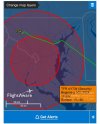
I fly into the SFRA from NY every few weeks. Not once has Garmin Pilot shown the 60 NM ring as a TFR. It only shows the 30 NM ring and the FRZ as TFRs.
The issue isn't on the ground when getting data via the internet. The issue is that in the air, when ForeFlight receives its data from ADSB towers, it shows the 60 NM ring as a TFR. Garmin Pilot (at least in my experience) does not.
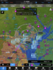
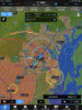
On your next flight into the SFRA, please take an airborne screenshot of Garmin Pilot while attached to an ADS-B FISB receiver. Obviously without an ADS-B FISB receiver, Garmin Pilot will not show the 60 NM ring. I took several pictures of my Garmin GNS 530W both before and nearing the DC area. I have both XMSirius and a GDL88 installed in my Bonanza with FISB. XM shows the 60 NM ring as a TFR as does the ADS-B FISB, only you need to be close to the DC area for the FISB to show the 60 NM ring. I also have similar screenshots of ForeFlight and Garmin Pilot. Both do not show the 60 NM ring when viewed using internet. I had a few screenshots of Garmin Pilot back in 2016 showing the 60 NM ring when airborne and near the DC area. I will try and get a screenshot from my airplane showing XM and using Garmin Pilot, but I have to do it in my local area near Charlotte, NC.


")