Why was it so bumpy? (Weather Explained?)

RyanB

Super Administrator
Management Council Member
PoA Supporter
Joined
Jul 21, 2010
Messages
16,587
Location
Chattanooga, TN
Display Name

Display name:
Ryan
Went flying after work today and it was oddly bumpy given the forecast and I’m unsure why. Winds aloft were pretty much nil and the general lapse through about 6,000ft was 3 degrees per thousand foot, nothing extraordinary. High pressure dominates the whole region. I didn’t make it above 5,500ft, but it was rough as a cob there and everything below that and very thermally. Again, not unusual given the day time heating, albeit it was late afternoon and surprisingly, there weren’t any AIRMETs for Turbulence.

For the weather guru’s, is there anything that would’ve indicated rough air given the conditions forecasted? Location is KCHA - KFGU. Has me puzzled.

IMG_5587.png
 
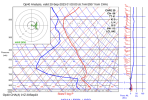
1695175885734.pngHere’s the Skew-T/Log-P for KCHA. It’s for now so things may have changed. But what I see is that, until about 7500 MSL, the red temperature line leaning pretty far left. I think anything left of the gray diagonals makes for instability. If it looked like this at the time, you were only a couple thousand feet from smooth air.

How did the temperatures aloft forecast compare with what you observed in the air?
 
View attachment 120761Here’s the Skew-T/Log-P for KCHA. It’s for now so things may have changed. But what I see is that, until about 7500 MSL, the red temperature line leaning pretty far left. I think anything left of the gray diagonals makes for instability. If it looked like this at the time, you were only a couple thousand feet from smooth air.

How did the temperatures aloft forecast compare with what you observed in the air?
Thanks, I’d bet that’s probably quite accurate to what it was, as the cloud bases were around there. Honestly, I don’t recall what the actual temps were. Where do you pull these Skew-T’s from?
 
Went flying after work today and it was oddly bumpy given the forecast and I’m unsure why. Winds aloft were pretty much nil and the general lapse through about 6,000ft was 3 degrees per thousand foot, nothing extraordinary. High pressure dominates the whole region. I didn’t make it above 5,500ft, but it was rough as a cob there and everything below that and very thermally. Again, not unusual given the day time heating, albeit it was late afternoon and surprisingly, there weren’t any AIRMETs for Turbulence.

For the weather guru’s, is there anything that would’ve indicated rough air given the conditions forecasted? Location is KCHA - KFGU. Has me puzzled.
My experience in the area (TN/VA) is that spring and fall have the worst thermal-type turbulence, I think due to having the largest temperature gradients between sun and shade and day and night. In the winter everything is cold and in the summer everything is hot.
 
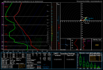
This was 5PM your local time if my math is correct. 5500MSL looks to be right where the SE flow near the surface switches to SW winds aloft. That usually creates some shear where those layers intersect. The lapse rate down low is 7.5C/km which is pretty steep, too.

hrrr_2023091918_003_35.06--85.3.png
 
Thanks, I’d bet that’s probably quite accurate to what it was, as the cloud bases were around there. Honestly, I don’t recall what the actual temps were. Where do you pull these Skew-T’s from?
I’m not an expert by any stretch of the imagination, but I like to pretend I understand something about the clouds and turbulence from these plots. Here’s my source: https://rucsoundings.noaa.gov/ (warning: works great if you have a pointer device but terrible on a phone or tablet without a trackpad).
 
Back
Top