islandboy
Pre-takeoff checklist
- Joined
- Feb 2, 2014
- Messages
- 332
- Display Name
Display name:
islandboy
I'm browsing the Gleim Instrument Pilot FAA Test Prep book and stumbled across a few seeming errors/contradictions (2015 edition).
Are there any knowledgeable souls out there with the book who can cast away the doubts?
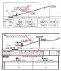
For SU 6:
#133 seems to have the wrong answer.
#154 seems to conflict with #157.
#200 seems to conflict with #206.
Are there any knowledgeable souls out there with the book who can cast away the doubts?
For SU 6:
#133 seems to have the wrong answer.
#154 seems to conflict with #157.
#200 seems to conflict with #206.

 I don't follow. To me, "descent gradient" would be in feet per nm, which is independent of ground speed as long as you're following the GS.