You are using an out of date browser. It may not display this or other websites correctly.
You should upgrade or use an alternative browser.
You should upgrade or use an alternative browser.
Skywagons at Johnson's Creek - Hilarious
- Thread starter denverpilot
- Start date
flyingcheesehead
Taxi to Parking
Yikes. 
Johnson Creek is beautiful... But even with its challenges it's probably the easiest airport in that area outside of McCall.
I couldn't laugh too much... I've had that conversation. People from the flatlands really don't respect the rocks.
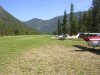
And on the off chance Nate hasn't seen it yet...

... My favorite picture.
Johnson Creek is beautiful... But even with its challenges it's probably the easiest airport in that area outside of McCall.
I couldn't laugh too much... I've had that conversation. People from the flatlands really don't respect the rocks.
And on the off chance Nate hasn't seen it yet...
... My favorite picture.
Attachments
denverpilot
Tied Down
Yikes.
Johnson Creek is beautiful... But even with its challenges it's probably the easiest airport in that area outside of McCall.
I couldn't laugh too much... I've had that conversation. People from the flatlands really don't respect the rocks.
Yeah, I've been dreaming of getting up there and doing some training and having some backcountry fun now for a couple of years. It's not going to fit the schedule or the budget this year, though. Have looked over the charts, and the videos, and the... well, everything I can get my hands on.
I guess I haven't had the misfortune of having that conversation with a flat-lander up here yet. There's some signs of it on message boards on the Net from time to time, but not to the extent of this "funny" video.
I do preach the "Check Density Altitude" mantra like it was a religion to anyone who says they're coming up here for a visit though... and takeoff and landing distances...
KAPA installed some "unofficial" but useful little reminders... DA calculators at each runway departure end that do a pretty close job of telling you exactly what DA is as you taxi by.
The one at the end of 17L said something like 8200' the day we departed fully-loaded in the 182 for Oshkosh last year, and it was the first time I saw almost three 1000' markers go by in the Skylane before being airborne...
But the numbers we'd crunched already told us that was what to expect.The reason I've always had an eyeball towards McCall and the airports around it was that Sparky Imeson "went up there" from here. Was very saddened his death in the second crash. Met him in the 90s, have two of his books signed by him...
 Super nice guy. He was working as a paralegal here in Denver back then, before he moved "up there".
I had the unenviable chore of contacting an old friend of his, who hadn't heard yet about the second crash, and then we talked for the next few days while they searched, and found... and recovered. It's really not fun to call up another aviator and say, "Have you heard about [insert name here].", in relation to Search and Rescue activity.
And on the off chance Nate hasn't seen it yet...
... My favorite picture.
Can't blame you there! Nice shot! Did you take it? If not, are you thinking about heading up there sometime? If I ever get the budget for more video gear, some video of going through their school and doing some flying up there would be grand.
#MountainCamp #BackcountryCamp? Take a bunch of flat-landers up to meet the rocks and trees off their wingtips for the first time?
")
gprellwitz
Touchdown! Greaser!
- Joined
- Jun 19, 2005
- Messages
- 12,774
- Location
- Romeoville, IL
- Display Name
Display name:
Grant Prellwitz
Oh yeah, he took it. Note N271G in the picture! He'll be by in a moment to link to his writeup on the trip, which was really spectacular!Can't blame you there! Nice shot! Did you take it? If not, are you thinking about heading up there sometime? If I ever get the budget for more video gear, some video of going through their school and doing some flying up there would be grand.
Bob Bement
Pattern Altitude
It seems lilke each year there is an airplane the lands long and hard, breaks something or goes off into the trees on the right side while landing on 17. Johnson creek is not that difficult by can still scare some pilots into making some bonehead plays.
dmccormack
Touchdown! Greaser!
- Joined
- May 11, 2007
- Messages
- 10,945
- Location
- Lancaster County, Pennsylvania
- Display Name
Display name:
Dan Mc
"Not really, but I have read many magazines..."
"It made my wife scream alot when we lost 5000 feet, but I think she forget about it..."
"It made my wife scream alot when we lost 5000 feet, but I think she forget about it..."
Last edited:
Gmaper
Pre-takeoff checklist
There is a live video cam at Johnson' Creek.
http://www.ruralnetwork.net/~yellowpinecm/
Today would not be a good time for a landing with a wheel undercarriage. The table in the foreground is a common picnic table and you can see that the snow is almost up to the seat bottom.
http://www.ruralnetwork.net/~yellowpinecm/
Today would not be a good time for a landing with a wheel undercarriage. The table in the foreground is a common picnic table and you can see that the snow is almost up to the seat bottom.
Bob Bement
Pattern Altitude
Johnson creek is taken care of by the Idaho Aeronautical Dept. they have a caretaker there each summer. He waters and mows the grass. He also takes care of renting out the two Vans that are used to go into Yellow Pine, ID, 4 miles down Johnson Creek. The runway is wide enough they sprinkle irrigate 1/2 of the runway at a time. You have to watch out for the sprinklers. Notoms found for Johnson Creek on Air Nav:
Additional Remarks
- ADDNL 250 FT OF LENGTH AVBL FOR TKOF ON RY 35 END.
- NO WINTER MAINTENANCE.
- NUMEROUS +60' TREES ADJACENT TO EACH SIDE OF RY.
- BE ALERT FOR SPRINKLERS ON RY.
- RECOMMEND LAND RWY 17; TKOF RWY 35 WHEN WIND CONDITIONS ALLOW.
- BIG GAME ANIMALS ON & INVOF AIRPORT.
- SPECIAL CONSIDERATIONS SHOULD BE GIVEN TO DENSITY ALTITUDE, TURBULENCE, AND MOUNTAIN FLYING PROFICIENCY.
Bob Bement
Pattern Altitude
Bob Bement
Pattern Altitude
And speaking of Density Altitude, on my trip down to AZ. in my 182, the last day of Dec. As I was listening to the Awos for Ely, NV. It reminded me that the DA was 3000 ft. I laughed as the Temp. on the ground was -20 with a field elevation of a little over 6200 ft.MSL.
flyingcheesehead
Taxi to Parking
I do preach the "Check Density Altitude" mantra like it was a religion to anyone who says they're coming up here for a visit though... and takeoff and landing distances...
KAPA installed some "unofficial" but useful little reminders... DA calculators at each runway departure end that do a pretty close job of telling you exactly what DA is as you taxi by.
And also "Check Density Altitude" on the ATIS there, and I think Front Range too (I remember hearing it at two airports that day). I like the DA calculators, that's a cool idea... Just gotta get people to pay attention.
Can't blame you there! Nice shot! Did you take it? If not, are you thinking about heading up there sometime? If I ever get the budget for more video gear, some video of going through their school and doing some flying up there would be grand.
Yup, I took it - N271G is "my" (club's) trusty Skylane.
I would love to get some more video going in there... Multi-camera this time. I would like to add a Canon DSLR and a POV video cam to my collection of gadgets, and added to the HV20 I should be able to get some shots out the front of the plane, out the side, maybe a face shot or out the other side too... And surely some RAM mounting gear for it all.
#MountainCamp #BackcountryCamp? Take a bunch of flat-landers up to meet the rocks and trees off their wingtips for the first time?
Would love to... After #SeaplaneCamp and #SkiplaneCamp are done.
Oh yeah, he took it. Note N271G in the picture! He'll be by in a moment to link to his writeup on the trip, which was really spectacular!
Haha... Well, I guess since you provided the segue and the impetus... Here's my writeup from that day.
Nicely done, Bob - I think you were either higher on downwind or made the downwind-final turn farther down the canyon than we did, or both... I remember crossing the centerline about halfway through the turn, and not having that long of a final either.
 As with everything flying, many ways to do it!
Unfortunately, I did not tape the arrival (I didn't really know anything about JC or how neat it was, I figured it was just another backcountry strip so I didn't have the camera on) but I did tape the departure, which was fun too!