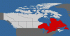
bstratt said:Okay, I got Canada but for some reason it only filled in black.
T....... nah, too easy

bstratt said:Okay, I got Canada but for some reason it only filled in black.
Everskyward said:Wow Steve, you're country's a lot bigger than everone else's. You've covered a lot more miles!
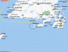
Barry's method of flying to France is a little more sedate than pulling a Lindberg. Put St. Pierre and Miquelon into Mapquest... **edit! That didn't work. See attached map, islands in the circle*** you will find that they are two islands off the coast of Newfoundland, and still territories of France.tonycondon said:good golly barry! go to france! that would be awesome. I dont get into the high risk flying stuff much (dusting, firefighting etc.) but for some reason ive been fascinated with the trans oceanic stuff in singles. I think it would be pretty amazing to see nothing but water.
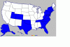
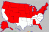
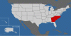
Is Oregon Washington's Mexico or is it California's Canada, no I know it is Idaho's Portugal!!Bob Bement said:With the exception of one or two posters I noticed all of you have missed Oregon.
Skip Miller said:Barry's method of flying to France is a little more sedate than pulling a Lindberg. Put St. Pierre and Miquelon into Mapquest... **edit! That didn't work. See attached map, islands in the circle*** you will find that they are two islands off the coast of Newfoundland, and still territories of France.
A cool way to get France in your logbook for sure!
-Skip
Henning said:Fly in to Sturgis...
Michael said:Ghery, you got a problem with Idaho?
Bob Bement said:With the exception of one or two posters I noticed all of you have missed Oregon. You need to try to add that state to your total.

tonycondon said:good golly barry! go to france! that would be awesome. I dont get into the high risk flying stuff much (dusting, firefighting etc.) but for some reason ive been fascinated with the trans oceanic stuff in singles. I think it would be pretty amazing to see nothing but water.


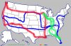
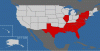
Nice trip! Here's your map (your trip in blue), augmented by two trips I took one summer -- but I was on a Honda.etsisk said:Well, I've not gone many places by little airplane, just yet . . . So here's a Harley trip I took a while back
bstratt said:I presume these are states you have landed in and not just flown over? Hmmm, I need a map with the names of the states cause I can't tell where they all are!(Don't rub it in Skip - I know I'm Canadian!!
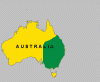
How about a map of North America including Canada?
Hmmm... I see Sturgis, I see maybe Daytona?Ken Ibold said:Nice trip! Here's your map (your trip in blue), augmented by two trips I took one summer -- but I was on a Honda.
smigaldi said:A bit eclectic for me
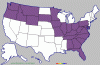
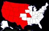
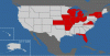
Been to all except Rhode Island and Delaware, I guess I had a hard time finding them lol!Troy Whistman said:Anybody here seen (in person, on the ground) all 50 states? That's what we're trying to do with our three girls before they are all out of the house. Been a family goal since they were little... gotta go make MY map now.
wbarnhill said:Let's try this again...
Create map here: http://www.world66.com/myworld66/visitedStates
Save image and attach here!
alaskaflyer said:Geez, Wm, you need to get out more!
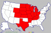
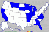
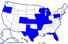
wbarnhill said:But here's the states I've visited (IL was just a hop from one plane to another at O'Hare but it does count... right?)
Yep, you see both. But that was before Bike Week in Daytona.etsisk said:Hmmm... I see Sturgis, I see maybe Daytona?
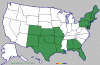
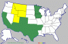
Grant if you've been to Detroit you could include the UP its still part of Michigan.gprellwitz said:Here's mine. I included the UP since I'm going there tomorrow. (And the back of the AF/D was helpful for identifying the states!
Doesn't show New Zealand or the Bahamas.
I have, on the ground, but I haven't flown into all of them. Let me try this map thing. Pesky little northeastern states and Hawaii...Troy Whistman said:Anybody here seen (in person, on the ground) all 50 states?