akpilot907
Pre-takeoff checklist
Hey all, I've had yet another brain fart..
This is what happens to you when you deploy...and not to mention I'm a low time IFR Pilot. I was sitting in my tent the other day planning an IFR trip to fly when I get back from this deployment and it struck me.. The airplane I have access to back home does not have a DME, approved IFR enroute GPS, (but it does have an 8 year out of date KLN 89b)... Now the airplane has dual VOR's and an ADF <----(CAN YOU BELIEVE IT!!)
If you guys/gals take a look at the chart I've attached, it's an Alaskan IFR Low chart... VORs are far and between.. and even the ones that look close, have 6,000ft MTs in the way.. so the lowest MEA in the state you can prob find is no less than 8-9,000ft.. Anywho, How do I identify a VOR change over point, and Identify a FIX (That doesn't have a VOR Cross radial)?? Can I use my KLN 89b (Which is an IFR GPS but the last it was current was in 2002) for DME reference only?
Thanks for the help guys!
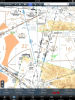