You are using an out of date browser. It may not display this or other websites correctly.
You should upgrade or use an alternative browser.
You should upgrade or use an alternative browser.
Name the airport
- Thread starter Don Jones
- Start date
SkyHog
Touchdown! Greaser!
- Joined
- Feb 23, 2005
- Messages
- 18,431
- Location
- Castle Rock, CO
- Display Name
Display name:
Everything Offends Me
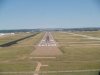
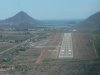
Well, its 35L, which means if its Texas, its probably going be be up near the panhandle. If it is Arizona, its going to be up north, most likely. Can't be NM, because there's no 35L at KABQ or KSAF (and that's a big ol' strip).
It appears there is another airport VERY close, as you can see it in the upper left corner....this is a good one, Don. I'll get this one.
edit: It is 11,000ft long or so....hmmm.
It appears there is another airport VERY close, as you can see it in the upper left corner....this is a good one, Don. I'll get this one.
edit: It is 11,000ft long or so....hmmm.
Last edited:
K
KennyFlys
Guest
Let's see... Left side of parallels (17-35), No intersecting runways, MALF, PAPI, probably ILS... I'm guessing at least 5,500 feet.
KFWS? Nope...
With that, I still found nothing within 218 returns showing up on an AOPA search.
Nick, I can't picture it that long with asphalt.
KFWS? Nope...
With that, I still found nothing within 218 returns showing up on an AOPA search.
Nick, I can't picture it that long with asphalt.
SkyHog
Touchdown! Greaser!
- Joined
- Feb 23, 2005
- Messages
- 18,431
- Location
- Castle Rock, CO
- Display Name
Display name:
Everything Offends Me
Let's see... Left side of parallels (17-35), No intersecting runways, MALF, PAPI, probably ILS... I'm guessing at least 5,500 feet.
KFWS? Nope...
With that, I still found nothing within 218 returns showing up on an AOPA search.
Nick, I can't picture it that long with asphalt.
The sign at the touchdown marker says "10" so I assume its ~11,000ft long. I may be misreading the sign. I will have this before I go to bed. Right now, I'm thinking possibly KCOS, but that might change in the next few minutes.
Last edited:
ScottM
Taxi to Parking
- Joined
- Jul 19, 2005
- Messages
- 42,529
- Location
- Variable, but somewhere on earth
- Display Name
Display name:
iBazinga!
The sign at the touchdown marker says "10" so I assume its ~11,000ft long. I may be misreading the sign. I will have this before I go to bed. Right now, I'm thinking possibly KCOS, but that might change in the next few minutes.
You are not misreading it. It is at least 10,000 feet long
SkyHog
Touchdown! Greaser!
- Joined
- Feb 23, 2005
- Messages
- 18,431
- Location
- Castle Rock, CO
- Display Name
Display name:
Everything Offends Me
My answer is now firm, I am about 90% sure it is Colorado Springs.
K
KennyFlys
Guest
AFD says KCOS 17L is concrete-grooved . Unless they consider possible concrete underneath?The sign at the touchdown marker says "10" so I assume its ~11,000ft long. I may be misreading the sign. I will have this before I go to bed. Right now, I'm thinking possibly KCOS, but that might change in the next few minutes.
 I wouldn't think so. It also refers to 17R as "Asphalt-Grooved"
COLORADO SPRINGS
CITY OF COLORADO SPRINGS MUNI
(COS) 6 SE UTC7(6DT) N38°48.35W104°42.05DENVER
6187 B S4
FUEL 100LL, JET A LRA ARFF Index C H–3E, 5A, L–6E
RWY 17L–35R: H13501X150 (CONC–GRVD) S–75, D–175, DT–400, DDT–850 HIRL CL IAP, AD
RWY 17L: MALSR. TDZL. PAPI(P4L)–GA 3.0° TCH 54. 0.6% down.
RWY 35R:
TDZL. REIL. PAPI(P4R)–GA 3.0° TCH 72. 0.6% up.
RWY 17R–35L:
H11022X150 (ASPH–GRVD) S–75, D–175, DT–340,
DDT–750 HIRL
RWY 17R:
REIL. PAPI(P4L)—GA 3.0° TCH 50. 1.2% down.
RWY 35L:
MALSR. PAPI(P4L)—GA 3.0° TCH 52. 1.2% up.
RWY 12–30:
H8269X150 (ASPH–GRVD) S–75, D–175, DT–280,
DDT–550 MIRL
RWY 12:
REIL. PAPI(P4R)—GA 3.0° TCH 65. 0.3% down.
RWY 30:
REIL. PAPI(P4L)—GA 3.0° TCH 52. Thld dsplcd 355. Hill.
0.5% up.
AIRPORT REMARKS:
Attended continuously. Turbo Jet training flights
prohibited 0600–1300Z‡. B52 operations prohibited. Rwy 17L
touchdown runway visual range avbl. Lgtd windsock apch Rwys
17L, 35R, 17R and 35L, 12 and 30. For REIL Rwy 12 and Rwy 30
and Rwy 17R ctc twr.
Other than that, KCOS seems to fit. I didn't even catch the signs you're referring to. You're quite correct on the distance, then. Doh! That was a bad boo-boo on my part!
Let'sgoflying!
Touchdown! Greaser!
Everskyward
Experimenter
- Joined
- Mar 19, 2005
- Messages
- 33,449
- Display Name
Display name:
Everskyward
t0r0nad0
Pattern Altitude
Oh, my guess was going to be Ellington Field, EFD, in Houston.
K
KennyFlys
Guest
The diagonal blows it.Oh, my guess was going to be Ellington Field, EFD, in Houston.
Don Jones
Line Up and Wait
Ding Ding Ding we have a winner! Nick got it correct first!
Here are some more pics of the Labor day trip.
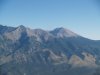
#1-- Picture looking to the big rocks to the north on our way through La Veta pass at 11,500
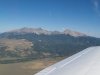
#2-- Another View
#3-- Free Baloon show on Monday morning
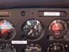
#4-- See a Warrior will fly fine at 11,500. We were doing 115 kts TAS with a GS of 114
Or here is the link to the entire trip. I haven't gone through them and cleaned up the trash
http://picasaweb.google.com/DonJonesCFI/ColoradoSpringsSept07
Here are some more pics of the Labor day trip.
#1-- Picture looking to the big rocks to the north on our way through La Veta pass at 11,500
#2-- Another View
#3-- Free Baloon show on Monday morning
#4-- See a Warrior will fly fine at 11,500. We were doing 115 kts TAS with a GS of 114
Or here is the link to the entire trip. I haven't gone through them and cleaned up the trash
http://picasaweb.google.com/DonJonesCFI/ColoradoSpringsSept07
Attachments

Last edited:
Don Jones
Line Up and Wait
Greebo
N9017H - C172M (1976)
- Joined
- Feb 11, 2005
- Messages
- 10,976
- Location
- Baltimore, MD
- Display Name
Display name:
Retired Evil Overlord
Looks like Tortola to me...
Don Jones
Line Up and Wait
Looks like Tortola to me...
Nope, wrong country. Remember I had to get there in my Warrior.
Greebo
N9017H - C172M (1976)
- Joined
- Feb 11, 2005
- Messages
- 10,976
- Location
- Baltimore, MD
- Display Name
Display name:
Retired Evil Overlord
What, it doesn't float? ;-)Nope, wrong country. Remember I had to get there in my Warrior.
Don Jones
Line Up and Wait
SkyHog
Touchdown! Greaser!
- Joined
- Feb 23, 2005
- Messages
- 18,431
- Location
- Castle Rock, CO
- Display Name
Display name:
Everything Offends Me
Re: Well that one was too easy
Well, its Mexico (you had to get there), there's water, which means its probably on one of the coasts. Runway 20 means that the water is off to the west, which means you are likely in the western part of Mexico, possibly near Baja.
Unfortunately, I do not have a Mexican airport guide....so I may be out of this one.
Cabo San Lucas.
Here is another. Extra points if you can figure this one out.
Hint: it is on foreign soil
Well, its Mexico (you had to get there), there's water, which means its probably on one of the coasts. Runway 20 means that the water is off to the west, which means you are likely in the western part of Mexico, possibly near Baja.
Unfortunately, I do not have a Mexican airport guide....so I may be out of this one.
Cabo San Lucas.
Don Jones
Line Up and Wait
Re: Well that one was too easy
Great deductive reasoning, right on all counts. It is on the Mexico mainland, not on the penninsula. It's not Cabo
Ok so here is a hint: It is an airport of entry and is on this list
http://www.aopa.org/members/files/travel/mexico/mex09.html
Well, its Mexico (you had to get there), there's water, which means its probably on one of the coasts. Runway 20 means that the water is off to the west, which means you are likely in the western part of Mexico, possibly near Baja.
Unfortunately, I do not have a Mexican airport guide....so I may be out of this one.
Cabo San Lucas.
Great deductive reasoning, right on all counts. It is on the Mexico mainland, not on the penninsula. It's not Cabo
Ok so here is a hint: It is an airport of entry and is on this list
http://www.aopa.org/members/files/travel/mexico/mex09.html
Last edited: