Let'sgoflying!
Touchdown! Greaser!
returning from flight training in Fla

http://www.ksdk.com/news/local/story.aspx?storyid=196405&catid=3
http://www.ksdk.com/news/local/story.aspx?storyid=196405&catid=3
How about Jesse's www.jesseweather.com?I don't know how to dig up past wx metars. Any ideas??
Wx at the scene?
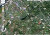
They crashed about 4-5 miles out; you're not going to get much closer. You can see the 2 mile scale at the bottom; the airport they were headed to is St. Louis Downtown, at the top left, they were on the extended centerline (ILS?) and ironically crashed at an a grass strip airport-home community, at marker "A".
If you can get weather for Scott AFB / MidAmerica in Illinois, that was about the same distance east of their position as they were from St. Louis Downtown, and will tell you if the weather was pretty constant over the area. With low pressure and 400' ceilings, I'm imagining it was.
They may have filed to the other airport, then tried to get into the residential airpark visually.
I was wondering the same thing...
What else would explain crashing 4 to 5 miles short, other than an altimeter setting error?
Trapper John
The flight track looks like there was quite a bit of ILS variation going on....
I wonder if there's some positioning error among the sites. The track log alternates between KGTS and Gateway (St. Louis) TRACON for the final 10 minutes of the Flightaware Log. Slightly before that, there are a few Kansas City Center hits in the mix...Wow, I'd say so...if the two radars shown on the track log are correct. But it looks like something is wrong.
Trapper John
Wow, I'd say so...if the two radars shown on the track log are correct. But it looks like something is wrong.
Trapper John
400' shouldn't be a problem for a current IFR pilot in a well equipped machine such as a Malibu.
This says it was on a missed, coming around for a second try. RIP, fellow aviators.
Yeah, when you zoom in at the end of their FlightAware track, there's some crazy stuff going on. Sobering. RIP, indeed.

Where is the airport in relation to this squiggle (the 'cruise' part looks like typical misregistration between two radar sites).
something doesn;t add up with the flightaware info, no surprise.
News says they were doing approaches at cps and the crash site was into a hangar but radar track shows them not really getting within range of the field?
The hangar is on a private airpark that is along the localizer for St Louis Downtown airport. It is probably coincidence that they crashed on an airport.
that is a coincidence,....I suppose. right?
And what about the radar, them not getting near the field but apparently having another go at it?
The other possibility of course would be that they set up for the approach with the goal to duck under the clouds, cancel IFR and get into the airpark. Given the really crummy weather in the metars above, that would seem rather odd.
Not to mention stupid. I really doubt that this is what was going on.And illegal...
Not to mention stupid. I really doubt that this is what was going on.
The failure scenarios really aren't any different than they are for any other decently equipped piston single....Right -- what failure scenario is possible in a Malibu? I assume redundant systems are standard?