MyassisDragon
Line Up and Wait
I had a good flight home from SC to MI yesterday and snapped some pictures while flying over the mountains. After a little reflection and looking at my Flight track I thought to myself "self this is a good example to share"
During my training I started with the impression IFR meant get in and go through the clouds in a straight line as filed. But it slowly changed during training and now I am really finding a lot of my Instrument flying this year is VFR (on ifr flight plan) dodging bad stuff.
I was flying a Tiger with WX-7 storm scope and Ipad/ADS-B weather Once above the initial layer Charlotte DEP approved requests for deviations (and concurred that it was a good idea) they also mentioned I must have on board weather so I replied ADS-B (plus I had visual on the build up or I never would have gone there).
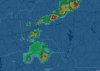
This was good to see the weather radar and look out the window at what it looks like with lightning and extreme precipitation from a distance. I also got a chance to see how ADS-B is only for general awareness by comparing our visual track around the backside of it compared to what was on the screen. According to Foreflight we went right through the heavy returns due to the delayed radar update. This was a real eye opener. But I do have to admit the new moving radar feature really gives a better indication of what the storm is doing than the static radar.
The pictures are from down near Charlotte at 9000ft and a snap shot from flightaware.
During my training I started with the impression IFR meant get in and go through the clouds in a straight line as filed. But it slowly changed during training and now I am really finding a lot of my Instrument flying this year is VFR (on ifr flight plan) dodging bad stuff.
I was flying a Tiger with WX-7 storm scope and Ipad/ADS-B weather Once above the initial layer Charlotte DEP approved requests for deviations (and concurred that it was a good idea) they also mentioned I must have on board weather so I replied ADS-B (plus I had visual on the build up or I never would have gone there).
This was good to see the weather radar and look out the window at what it looks like with lightning and extreme precipitation from a distance. I also got a chance to see how ADS-B is only for general awareness by comparing our visual track around the backside of it compared to what was on the screen. According to Foreflight we went right through the heavy returns due to the delayed radar update. This was a real eye opener. But I do have to admit the new moving radar feature really gives a better indication of what the storm is doing than the static radar.
The pictures are from down near Charlotte at 9000ft and a snap shot from flightaware.