MAKG1
Touchdown! Greaser!
- Joined
- Jun 19, 2012
- Messages
- 13,411
- Location
- California central coast
- Display Name
Display name:
MAKG
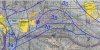
KTCY has several obstacle departure procedures, all of which terminate at Modesto VOR (MOD).
MOD has one airway, and it goes the wrong way. Having tried direct routing before, ATC doesn't seem to do it through clearance (though they do with vectors).
The OROCA at MOD VOR is 9300 feet due to the way they are gridded. Actual terrain in the area is almost completely flat and near sea level. The MVA is probably 2000, based on previous experience with approaches at the co-located airport (KMOD).
So, it's pretty clear that the way I'd get to Livermore (KLVK) IRL is vectors over the whole route, but how would one file this? KTCY MOD PATYY ECA TRACY KLVK? Ouch. Aircraft is equipped /G, so the apparent reception problem on the chart for ECA is not a factor unless the GPS blows up.