Foreflight Eclipse Map Layer

jwyatt

Pre-Flight
Joined
Aug 31, 2007
Messages
73
Location
Goodhue, Minn.
Display Name

Display name:
jwyatt

Attachments

  • IMG_0713.jpeg
    IMG_0713.jpeg
    2.6 MB · Views: 94
Funny. I was just looking because at the end of a webinar (I think it was a SocialFlight one) they mentioned an eclipse KML file on the site. I checked and couldn't find it.
 
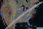
My wife and I were talking eclipse last night, and I couldn’t easily find a Foreflight custom layer for this one, like I found in 2017. So I made one. Sharing in case it may be of use to anyone else. The centerline is drawn, and 30-second bands of duration (starts with purple at 4:00+).


Data from https://svs.gsfc.nasa.gov/5073, with some massaging and colors to make it pretty.
 
Thanks for the data, but not useful without a process.
 
Can the file be edited to load only the portion close (500 miles) to my vicinity?
 
My wife and I were talking eclipse last night, and I couldn’t easily find a Foreflight custom layer for this one, like I found in 2017.
There is a ForeFlight Content Pack available for this too. This has selectable layers for 4 minutes of totality, 3 minutes, the full path, and markers with times that the totality starts and ends.

 
Hmmm, I tried using Garmin Pilot, but it limits KML files to 4MB.
 

Attachments

  • WechatIMG438.jpg
    WechatIMG438.jpg
    383.1 KB · Views: 10
  • WechatIMG4319.jpg
    WechatIMG4319.jpg
    687.8 KB · Views: 10
Back
Top