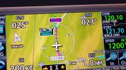
When flying approaches with the GTN 650 the step down altitudes are shown on the map. They are a very useful situational awareness item particular on an LNAV with a ton of step downs. The distance rings are plotted on top of these altitudes and at times cover them up making them impossible to read.
Is there a way to tell the 650 to plot the altitude on top so it's drawn on top of the distance rings and not under them? The 650 is an awesome tool but this is one of my few annoyances.
Is there a way to tell the 650 to plot the altitude on top so it's drawn on top of the distance rings and not under them? The 650 is an awesome tool but this is one of my few annoyances.