Altitude Readability on GTN 650

Skylark23

Pre-Flight
Joined
Oct 15, 2023
Messages
38
Display Name

Display name:
Skylark
When flying approaches with the GTN 650 the step down altitudes are shown on the map. They are a very useful situational awareness item particular on an LNAV with a ton of step downs. The distance rings are plotted on top of these altitudes and at times cover them up making them impossible to read.

Is there a way to tell the 650 to plot the altitude on top so it's drawn on top of the distance rings and not under them? The 650 is an awesome tool but this is one of my few annoyances.
Here is an example from the iPad sim.
 

Attachments

  • 20240704_195854.jpg
    20240704_195854.jpg
    5.6 MB · Views: 41
I agree that the GTN 650 is a great device... however, I personally find it quite useless (as is the GTN 750 IMHO) for displaying approach plates and altitudes on the map. I turn off the GTN option for plates-on-map... and use the iPad/ForeFlight for much easier reading of approach plates (including stepdown altitudes and minimums on the map).
 
When flying approaches with the GTN 650 the step down altitudes are shown on the map. They are a very useful situational awareness item particular on an LNAV with a ton of step downs. The distance rings are plotted on top of these altitudes and at times cover them up making them impossible to read.

Is there a way to tell the 650 to plot the altitude on top so it's drawn on top of the distance rings and not under them? The 650 is an awesome tool but this is one of my few annoyances.

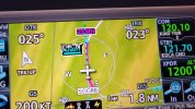
Since you have the distance to the next fix displayed in the lower right, you could turn the range ring off for an approach. That could help.
 
I’ve never even considered using a GTN650 in this manner. During an IAP, I use the default nav page simply because that gives you direct access to CDI swapping which is helpful on certain kinds of approaches.
 
A lot of people have ADS-B traffic displayed on the GTN making the map page preferable as the default screen. I think the map page is also an invaluable aid to situational awareness as well.

It's important to explore your GTN's features at all levels and find what works best for you. That said, I think the universal consensus is that approach plates on GTN, especially a 650 is a bad idea.

Just another point of view.
Just to be clear, approach plates can't be displayed on the 650, only the 750. You can have a map view that has fixes and altitudes.
 
A lot of people have ADS-B traffic displayed on the GTN making the map page preferable as the default screen. I think the map page is also an invaluable aid to situational awareness as well.
I know a lot of people do that. I don't do it that way because (a) I think my EFB with its larger screen give me better situational awareness; (b) if need to mark something on the map or approach/SID/STAR chart, I can; and (c) I feel the map page doesn't really give me anything the EFB plus the flight plan page gives me better.

The small 650 makes it obvious to me, but I do it with the larger units as well. And you don't get plates of the 650 anyway.
 
Just to be clear, approach plates can't be displayed on the 650, only the 750. You can have a map view that has fixes and altitudes.
This is simply a SA tool to assist my scan if I am single pilot in IMC. Having the next waypoint with altitude shown is super helpful.

iPad always has the approach plate with traffic displayed.
 
Back
Top