You are using an out of date browser. It may not display this or other websites correctly.
You should upgrade or use an alternative browser.
You should upgrade or use an alternative browser.
Altitude over I-70
- Thread starter David Loftus
- Start date
You got it.Pew Al Up ?
One of these years I'm gonna take the class. I go right through La Veta driving for the elk hunt. I'd like to fly into KSKX from the Midwest. I wouldn't dare pull it off without taking a course being a flatlander. I always thought La Veta was one of the "easier" passes from my Google searchesKinda. Which pass you want to use?
La Veta has a habit of eating airplanes but mostly because it’s incredibly long even though it’s not as high as say, Rollins.
I’ve never figured it out completely. You are kinda committed once you’re way up in there but it’s still very wide. I think folks fly up the middle where you’re not supposed to be… and yeah the downdrafts in there can be impressive.
The wind absolutely screams through that pass out on to the plains with any pressure difference.
I do like the southerly routes better than the northerly ones for terrain you might survive a landing in.
denverpilot
Tied Down
One of these years I'm gonna take the class. I go right through La Veta driving for the elk hunt. I'd like to fly into KSKX from the Midwest. I wouldn't dare pull it off without taking a course being a flatlander. I always thought La Veta was one of the "easier" passes from my Google searches
I wouldn’t go so far as to say don’t do it — it’s kinda like VFR flying cross country. There’s days when you can and days when you should stay on the ground.
That said, nothing wrong with personal minimums.
On a calm day, flying over mountain passes in the cool of the day where you have at least some performance margin and a healthy ability to turn around and go back if it gets turbulent… is wonderful stuff.
denverpilot
Tied Down
Was thinking follow US 24 through Wilkerson Pass, then turn north at Buena Vista and follow the railroad. Seems pretty benign when I've driven that route. Tennessee Pass to Minturn would be hairy if you had a problem, but it's down valley.
Wilkerson is great. It’s short and sweet and then you’re in the Alamosa Valley.
As someone else said, then south from there. Ponca.
All of these on good weather days.
And agreed, stay out of Monarch. The number of days it isn’t ripping the AWOS anemometer off the State radio tower are very few up there.
Oh yeah. The Mountain AWOSes. Great resource.
On a nice day….instead of LaVeta, go a bit further north, straight line west from Spanish Peaks 4v1 take Mosca Pass (wider than LaVeta Pass )and you pop out over the Great Sands Dunes!One of these years I'm gonna take the class. I go right through La Veta driving for the elk hunt. I'd like to fly into KSKX from the Midwest. I wouldn't dare pull it off without taking a course being a flatlander. I always thought La Veta was one of the "easier" passes from my Google searches
bbchien
Touchdown! Greaser!
I won't do that route w/o TWO Firebreathing engines and well undergross.
Rapid City, V536 Newcastle, Muddy Mtn V235 Rock Springs V6 Ft Bridger SLC can be done at 12,000
Rapid City, V536 Newcastle, Muddy Mtn V235 Rock Springs V6 Ft Bridger SLC can be done at 12,000
Last edited:
denverpilot
Tied Down
I'm an idiot, MOSCA is great for the Alamosa valley... Wilkerson is the high pass straight west of Leadville right? Whichever one that is, two of my mountain instructors both say that's the pass (between ASE and Leadville) where they've come the closest to hitting rocks... on days that didn't look that bad. It's very high and if the wind switches to southerly, you'll get horrendous downdrafts right at the narrowest and highest spot.Wilkerson is great. It’s short and sweet and then you’re in the Alamosa Valley.
I've been through it on a nice day and it takes freaking fooooooorrrrreeeeeevvvveeeerrr to climb out of ASE, then double back along the ridge to the north and get to tjhe altitude to get over it.
Anyway, definitely mixing up pass names....
That's Aspen/Leadville = Independence Pass. Not fun in a car (1 lane in some places) definitely not in an airplane because the pass is so narrow there's no way to turn and get out of trouble. HIghly recommended by Colorado Pilots Assoc, Colorado Civil Air Patrol, and everyone else around here to NOT fly Independence Pass.I'm an idiot, MOSCA is great for the Alamosa valley... Wilkerson is the high pass straight west of Leadville right? Whichever one that is, two of my mountain instructors both say that's the pass (between ASE and Leadville) where they've come the closest to hitting rocks... on days that didn't look that bad. It's very high and if the wind switches to southerly, you'll get horrendous downdrafts right at the narrowest and highest spot.
I've been through it on a nice day and it takes freaking fooooooorrrrreeeeeevvvveeeerrr to climb out of ASE, then double back along the ridge to the north and get to tjhe altitude to get over it.
Anyway, definitely mixing up pass names....
Wilkerson is east of the mountain line that's the east "wall" of Leadville/Buena Vista/Salida valley. It's almost a no-brainer, if you don't know where it is, you might not even notice it other than being on the map. I just stay at 12.5 going west and look for the 2 little lakes. Don't forget to look down and see South Park. Yes, that's a real little town.
For those interested, you can download the Colorado DOT Div of Aeronautics map of the state with details on all the passes and the digital book of all 72/74 airports in the state at
https://www.codot.gov/programs/aeronautics
Might provide answers to many questions here. Plus both are fun to read. I hand last year's paper versions out at the Young Eagle ground school we teach. Kids love having something in their hands, and it keeps the out of date material out of the trash bin. Well, at least out of our trash bins.
This is why I wouldn't attempt it without taking a course. One of those things I don't know what I don't know.I wouldn’t go so far as to say don’t do it — it’s kinda like VFR flying cross country. There’s days when you can and days when you should stay on the ground.
That said, nothing wrong with personal minimums.
On a calm day, flying over mountain passes in the cool of the day where you have at least some performance margin and a healthy ability to turn around and go back if it gets turbulent… is wonderful stuff.
Ed Haywood
En-Route
What does CPA say about Tennessee Pass going from Leadville?That's Aspen/Leadville = Independence Pass. Not fun in a car (1 lane in some places) definitely not in an airplane because the pass is so narrow there's no way to turn and get out of trouble. HIghly recommended by Colorado Pilots Assoc, Colorado Civil Air Patrol, and everyone else around here to NOT fly Independence Pass.
Wilkerson is east of the mountain line that's the east "wall" of Leadville/Buena Vista/Salida valley. It's almost a no-brainer, if you don't know where it is, you might not even notice it other than being on the map. I just stay at 12.5 going west and look for the 2 little lakes. Don't forget to look down and see South Park. Yes, that's a real little town.
For those interested, you can download the Colorado DOT Div of Aeronautics map of the state with details on all the passes and the digital book of all 72/74 airports in the state at
https://www.codot.gov/programs/aeronautics
Might provide answers to many questions here. Plus both are fun to read. I hand last year's paper versions out at the Young Eagle ground school we teach. Kids love having something in their hands, and it keeps the out of date material out of the trash bin. Well, at least out of our trash bins.
I dunno....grab/download the map and check. I'm at work and don't have the detailed notes from the course.What does CPA say about Tennessee Pass going from Leadville?
By the way, anyone interested can sign up for the CPA and/or the NMPA courses at
Mountain Flying Page - Colorado Pilots Association
Mountain Flying - New Mexico Pilots Association
Here are the directions from Aspen to Leadville thru Tennessee pass:
1. After takeoff from Aspen runway 33, turn right approximately 30 degrees to clear runway 15 approach lane. Continue climb to 11,500 feet MSL while proceeding westbound along the north side of the valley.
2. Approaching the Basalt-El Jebel-Spring Park Reservoir area, begin turning right to follow the valley south of the Eagle Airport and then eastbound to Avon. After Avon continue turning to the right until arriving over the town of Minturn.
3. Cross Minturn at 11,500 feet or higher and continue along the deep valley to Tennessee Pass.
4. Tennessee Pass is a "V" shaped pass. Extra altitude is recommended for this crossing.
5. Adhere to the proper headings as there are INVITING, WRONG, VALLEYS from Minturn to Tennessee Pass.
6. Fly on the updraft side of the valley as Tennessee Pass is approached. Turn on landing lights before reaching the pass.
7. After landing at Leadville, pick up your certificate for landing at the highest paved, public use airport in the United States of America.
Wagondriver
Line Up and Wait
- Joined
- Mar 7, 2020
- Messages
- 668
- Display Name
Display name:
375Taylor
The mountains are really not that scary! If you are flying anything with ANY performance, you can readily fly all over Colorado.What does CPA say about Tennessee Pass going from Leadville?
Tennessee pass is NOT a steep valley with rocks pointing out to grab you, in fact that is the case with almost every pass. Independence pass is tight in a car, but not in an airplane, but it is high. If you have an airplane that can't get to 14k, don't fly in the mountains. Sure there are plenty of wrecks around there, watch the weather, look at the barometer in various places. Remember from private pilot training that air move from high pressure to low pressure? Could create a downdraft on the low pressure side.
Flying in the mountains where there is traffic, fly the right side of the valley. ( the traffic going the other way will be on their right side). Give yourself room to turn around, but that isn't hard in most passes. If the winds are crappy, go back. Cross ridges at a 45 degree angle if you suspect you are on the leeward side. Watch a basic mountain flying video, there are plenty out there by good instructors. If you are unsure of winds, cross passes at 1000 agl, from a 45. From the windward side, expect an updraft, then a downdraft on the leeward side. In an updraft pitch up, get as much out of it as you can, in a downdraft, pitch down and gain airspeed to get out of it as quick as possible. Usually the ups and downs last far less than a minute.
I realize many people unfamiliar with high DA ops crash in the mountains. It seems this is mostly due to failure to understand performance loss, and perhaps the failure to understand weather. Those of us based at high DA, fly all the time in the high country, for just a nice morning sight seeing flight. The mountains will not reach up and grab you. Get to pass crossing altitude several miles before you get there, if you can't, turn around.
If its a nice clear day, the winds aloft forecast is good, there are no lenticulars, go check it out. Check it out with lots of clearance to the ground. I've got a friend that did flight training in a 150 with an 0200, out of RIL. Two normal size guys CAN land AND takeoff from KGWS on a summer morning.
There are days that flying a single piston in the mountains is a bad idea, but there are LOTS of days where it is not.
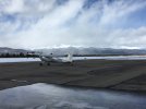
Photo is Leadville, looking toward KEGE. NOT a good day to fly over the divide.
Attachments
denverpilot
Tied Down
No disagreement. It can be great fun.
For those reading along note the somewhat wishy washy limits he mentions though. “Maybe this” and “maybe that”.
That’s the stuff COPA tries to flesh out in the course.
Stuff like item 5 in the list above. Turning up the wrong valley in there can mean no way out or a serious ass puckering course reversal.
These days with an iPad or just the way I learned, keep your finger on the paper chart and know everything you’re seeing out the window matches exactly where you think you should be… and know your “out” at all times…
You really can enjoy the rocks on a good weather day.
The photo is an instant “peaks obscured” thought without even thinking about it for me from that ramp there. And you can’t outclimb that cloud layer.
It just takes practice and a bit of a different mindset. Without those rocks in that photo and the DA, that’s a standard crap layer to climb out thru in the Midwest. Grin.
It’s a margins thing. You run out of them pretty quick.
I’ve departed LXV off the top of my Cessna performance chart. It was only 72F. The airplane did as expected, the world’s slowest high altitude cruise climb. Wasn’t even 500 ft/min. But we knew that was how it was going to go. Don’t try and pull the nose up anymore. Just … wait. You cleared the treeline. Now turn gently toward Buena Vista and let the terrain falling away be your “climb rate”.
It all makes sense from the physics point of view. Just pay close attention to the performance charts and visualize what it really means.
“It’s going to take ten minutes of max performance climb to be 1000’ above that pass… if we aren’t getting book performance our out is to reverse course to the right and fly down valley and we need 800’ AGL minimum to make that turn.”
David Loftus
Pre-takeoff checklist
I love flying the mountains on beautiful days, but I don't take chances when the winds are up or visibility is down. Diamonds are incredible to fly on smooth days, but a 39'6" wingspan and light wing loading makes them very uncomfortable in moderate turbulence. I'm definitely a fair-weather fan ;-)
- Joined
- Mar 4, 2007
- Messages
- 337
- Display Name
Display name:
Don
I’m resurrecting this thread, as it was useful to me for my flight from Ely, NV to Boulder, CO, today. Perhaps will be of use to others, too.
Just me, in a 200 hp normally aspirated piper Arrow
I got off before 8, PDT, under ideal conditions- moderate temps, light winds at altitude. Flight following the entire route. Was able to fly through the Sevier MOAS with Clover control out of Hill AFB. There are significant mountains to the east of KELY, circled a bit, ultimately flew almost all of the route- KELY-Sacramento pass-Glenwood Springs-Kremmling-Rollins Pass-KBDU, at 13,500
I chose to go high, early, so I wouldn’t have to worry about canyon climbs-that allowed me to periodically check my actual climb rate at that altitude en route, without actually climbing. I did climb to just over 14 k as I crested Rollins.
The mountain pass AWOS system is great, but I couldn’t reach the Dakota Hill AWOS (sunlight mountain was loud and clear)
I got handed off from one center frequently to another right at the crest of the front range, which makes sense, but I was so intent on flying the airplane at corona/Rollins, it was a distraction to me.
Even with negligible winds aloft there were times when I was surprised by sudden downdrafts- fortunately largest was just after I’d crossed the crest at Rollins, where terrain drops off fast.
Enjoyable, but not something I’d want to do with any less HP than I had (200), passengers, without O2, or on anything other than an ideal day, weather wise.
I have a fair amount of mountain time over/in the sierras, but was very cognizant that I don’t know the CO terrain.
Tavaputs plateau, Green river, Eagle (EGE) with the front range crest high points such as Longs visible on the horizon, looking south at Winter Park, and happy to be around in Boulder. Quite a bit of glider activity this morning there.
Attachments
- Joined
- Mar 4, 2007
- Messages
- 337
- Display Name
Display name:
Don
For return to west (Bay area)- do you have an opinion as to crossing front range just north of Rocky Mtn NP - cache la poudre river drainage and Cameron Pass?
Or Estes Park/Milner pass?
@murphey or others in the know?
If you're that far north, just head to the CO/WY state line. Much lower geography, more outs, much less time over terrain.
Just because there's a pass identified on the map doesn't mean it's a good idea for flight. Do you have the CO Aeronautics map of recommended passes?
Hm....looks like you can download the book of airports but not the map. If you have time, email them and they'll send you a map or if you stop at any Colorado airport, they usually have paper copies of the map.
Fortunately, I have one in front of me, and here are the details on Cameron Pass.
"The pass is not visible to any weather reporting stations"
On the map, Cameron Pass is listed graphically as a recommended route:
Steamboat (SBS) to Rabbit Ears Pass to Cameron Pass to NE to avoid the Rawah Wilderness area then past the Red Feather Lakes to Poudre Park and now you're in relatively flat-ish land.
Personally, I don't feel comfortable in my cherokee 180 over that much terrain for that much time.
I just sent a note to Aeronautics asking why the map isn't online.
SBS to FNL can be done at or below 10,500 msl. Follow the power lines...It's a route I've used many times when the wx goes DS. As murphey mentions, there's a lot of terrain so modify the route as you deem necessary to fly over the less bumpy stuff.
As for other comments about a pass *only* being 12,000 or so feet. Remember the density altitude can be several thousand feet higher and NA aircraft will run out of climb. It happens every few years and somebody does the stall/spin thing without ever learning why they couldn't climb anymore.
As for other comments about a pass *only* being 12,000 or so feet. Remember the density altitude can be several thousand feet higher and NA aircraft will run out of climb. It happens every few years and somebody does the stall/spin thing without ever learning why they couldn't climb anymore.
Former local but yes, sharing knowledge is part of the purpose for POA. I'm still in the inter-mountain west but a bit further south and as other have mentioned the wx is much different around here. A lot more classic mountain wx patterns rather than the confused mess of north/central Colorado.Appreciate the pure from a local, @miainco!
As @murphey suggests and as it was pointed out to me in a Sectional Chart presentation many years ago, the passes on the chart indicate where the roads are. They do not indicate in any way that it’s safe to fly through them. In some cases it might be the worst place to fly. I taught that as an important component of basic mountain flying.
Assuming little mountain experience, I agree heading a little north over lower and more hospitable terrain is a good idea.
Assuming little mountain experience, I agree heading a little north over lower and more hospitable terrain is a good idea.
Very true about the power lines - Steamboat to Rabbit Ears Pass to Kremmling (20V) then Rollins/Corona Pass and now you're back on this side of the Front Range. That's one of the Colorado Pilots Assoc Mtn Flying class routes.SBS to FNL can be done at or below 10,500 msl. Follow the power lines...It's a route I've used many times when the wx goes DS. As murphey mentions, there's a lot of terrain so modify the route as you deem necessary to fly over the less bumpy stuff.
As for other comments about a pass *only* being 12,000 or so feet. Remember the density altitude can be several thousand feet higher and NA aircraft will run out of climb. It happens every few years and somebody does the stall/spin thing without ever learning why they couldn't climb anymore.
Other power lines murphey, the ones that take you to the old St. Vrain power plant. Much lower altitude than going over Corona. Yes, it's a longer trip but it's an out when you can't get over Corona. Side note with that route: 33V is a place to wait out wx if you have to do so. Don't plan on doing anything else there, no services. LAR is a better out if you don't mind a slight breeze.Very true about the power lines - Steamboat to Rabbit Ears Pass to Kremmling (20V) then Rollins/Corona Pass and now you're back on this side of the Front Range. That's one of the Colorado Pilots Assoc Mtn Flying class routes.
33V very true....but only locals remember St Vrain, and it's not on any map these days.Other power lines murphey, the ones that take you to the old St. Vrain power plant. Much lower altitude than going over Corona. Yes, it's a longer trip but it's an out when you can't get over Corona. Side note with that route: 33V is a place to wait out wx if you have to do so. Don't plan on doing anything else there, no services. LAR is a better out if you don't mind a slight breeze.
That would be news to the FAA then:No power plants allowed on charts, can't use them for visual navigation. Power plant safety concerns I'm sure (wink, wink, wink). Gliders are a real threat to power plants...

That's the Calvert Cliffs nuclear plant.
The Salem plants don't say power plant but they do say "stacks and cooling towers" on the chart.
Capt. Geoffrey Thorpe
Touchdown! Greaser!
- Joined
- Jun 7, 2008
- Messages
- 16,084
- Location
- DXO124009
- Display Name
Display name:
Light and Sporty Guy
Directly under the RNAV (GPS) approach to runway 22 at ONZ On the sectional they only show the Mish symbol.The Salem plants don't say power plant but they do say "stacks and cooling towers" on the chart.

But, as far as I know, only glider pilots have been arrested for violating nuclear power plant airspace.
Amusingly, those cooling towers are not limited to nuclear plants and not all nuclear plants have them. They are used whenever you need to cool turbine water and you're not allowed to dump it in a nearby body of water.
No it wouldn't be news the the FAA, they are the ones that removed them. The fact that you can find some only points to the usual lack of attention to detail from a government agency. HAND and HTHThat would be news to the FAA then:
View attachment 133948
That's the Calvert Cliffs nuclear plant.
The Salem plants don't say power plant but they do say "stacks and cooling towers" on the chart.
")
Ed Haywood
En-Route
And also to the usual silliness of bureaucratic decision making, given that a search for "nuclear power plant" on Google Maps yields unlimited info.The fact that you can find some only points to the usual lack of attention to detail from a government agency.
What was really idiotic was the notam they put out after 9/11 telling you to avoid nuking plants by giving rather imprecise locations of them. Several were listed in the wrong state from where they really were. They listed one of the Salem plant in Delaware (it's in NJ). At one time they even put the two units of the same plant a widely different locations. Of course, a bit of googling gets you maps where they all really are.
