SCORE! AirVenture 2011 on Google Earth

TangoWhiskey

Touchdown! Greaser!
Joined
Feb 23, 2005
Messages
14,210
Location
Midlothian, TX
Display Name

Display name:
3Green
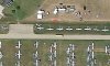
I picked up a 3DConnexion Space Navigator for use with Autodesk Inventor, and saw that it works smoothly with Google SketchUp and Google Earth, too... so I fired up Google Earth to "fly around" a bit, and ended up zooming directly into Fond Du Lac, WI... so I flew up the highway a bit to Oshkosh and thought "Cool! They happened to take their imagery when an AirVenture was going on!"

Then I noticed the Rutan aircraft at AeroShell Square and thought "COOL! That's from THIS YEAR!"

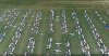
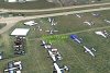
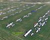
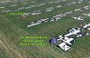
So I flew around a bit more and saw some of our POA friends! Can you find your plane or campsite? I looked for Grant and Leslie's campsite but didn't find it... but then, others had problems locating it too, as I recall!!

attachment.php


attachment.php


attachment.php
 

Attachments

  • ScreenShot134.jpg
    ScreenShot134.jpg
    89.8 KB · Views: 171
  • ScreenShot135.jpg
    ScreenShot135.jpg
    106.1 KB · Views: 174
  • ScreenShot136.jpg
    ScreenShot136.jpg
    86.3 KB · Views: 169
Last edited:
Found Our Campsite - this image was taken before the rains or my arrival, probably on opening day.

<?xml version="1.0" encoding="UTF-8"?>
<kml xmlns="http://www.opengis.net/kml/2.2" xmlns:gx="http://www.google.com/kml/ext/2.2" xmlns:kml="http://www.opengis.net/kml/2.2" xmlns:atom="http://www.w3.org/2005/Atom">
<Document>
<name>KmlFile</name>
<Style id="sn_ylw-pushpin">
<IconStyle>
<scale>1.1</scale>
<Icon>
<href>http://maps.google.com/mapfiles/kml/pushpin/ylw-pushpin.png</href>
</Icon>
<hotSpot x="20" y="2" xunits="pixels" yunits="pixels"/>
</IconStyle>
</Style>
<Style id="sh_ylw-pushpin">
<IconStyle>
<scale>1.3</scale>
<Icon>
<href>http://maps.google.com/mapfiles/kml/pushpin/ylw-pushpin.png</href>
</Icon>
<hotSpot x="20" y="2" xunits="pixels" yunits="pixels"/>
</IconStyle>
</Style>
<StyleMap id="msn_ylw-pushpin">
<Pair>
<key>normal</key>
<styleUrl>#sn_ylw-pushpin</styleUrl>
</Pair>
<Pair>
<key>highlight</key>
<styleUrl>#sh_ylw-pushpin</styleUrl>
</Pair>
</StyleMap>
<Placemark>
<name>2011 POA Campsite - Prellwitz and Metzinger</name>
<LookAt>
<longitude>-88.58097145245368</longitude>
<latitude>43.97519681198848</latitude>
<altitude>0</altitude>
<heading>-0.2405232609712014</heading>
<tilt>35.86821331138624</tilt>
<range>31.22376958584887</range>
<altitudeMode>relativeToGround</altitudeMode>
<gx:altitudeMode>relativeToSeaFloor</gx:altitudeMode>
</LookAt>
<styleUrl>#msn_ylw-pushpin</styleUrl>
<Point>
<altitudeMode>clampToGround</altitudeMode>
<gx:altitudeMode>clampToSeaFloor</gx:altitudeMode>
<coordinates>-88.58097145245367,43.97519681198848,0</coordinates>
</Point>
</Placemark>
</Document>
</kml>
 

Attachments

  • prellwitz.kml
    1.5 KB · Views: 6
Last edited:
How cool! Now I can show people where I parked! Thanks! :)
 
maps.google.com has this imagery on it now as well, for those that don't want to download a package. :D

Great find!
 
Row 510... I found me! :D Archer II...Purple wingtips and blue and tan tent that leaks... a lot. :rolleyes2:

Row510Oshkosh2011.jpg


Thanks, Troy! Very cool!! :D
 
Cool indeed! I found my camp site but not sure how to save the image.
 
I found where I parked the RV-8, and quite possibly also myself and the group of folks I was eating lunch with in the VIP parking lot behind the homebuilder forums! Looks like the overhead photos were taken around 1PM on Monday.
 
You guys look like a bunch of airplane pancakes. Very cool though!
 
I can tell about when the picture was taken. They caught my airplane along with four other Barons and some Bonanzas getting ready to taxi for our opening Showcase flight on Monday around 2PM.

My airplane is the twin in a taxi row by itself towards the right side of the picture.
 

Attachments

  • Osh2011.jpg
    Osh2011.jpg
    275.8 KB · Views: 23
I haven't been to OSH, yet, and this is the first time I've seen the 'big picture'. What are all those vehicles parked along the east edge?
 
Back
Top