Route suggestions for CA to NC helicopter XC

Davelength

Filing Flight Plan
Joined
Sep 23, 2021
Messages
8
Display Name

Display name:
Dave
I'll be doing a ferry flight from the Sacramento area to Raleigh in a helicopter, and would love any tips or advice from someone that has done a similar trip. I'll be heading south to avoid the mountains, at least into NM. From there the terrain is a bit easier to navigate. Route suggestions, places to stop or avoid, what to pack, things of that nature? Thanks!
 
Revell!

Sorry, couldn't resist...
 
You want to depart early, afternoons are going to more turbulent.

Southern route is generally the best combination of weather and lower terrain.
 
I'll be doing a ferry flight from the Sacramento area to Raleigh in a helicopter, and would love any tips or advice from someone that has done a similar trip. I'll be heading south to avoid the mountains, at least into NM. From there the terrain is a bit easier to navigate. Route suggestions, places to stop or avoid, what to pack, things of that nature? Thanks!
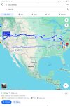
1710778135058.png
 
I'd go south to Bakersfield, through the pass at Tehachapi, south around the Edwards Airspace, Lancaster to Victorville (Rte138 & Rte 18 Pearblossom Hwy) then follow I-15 to Barstow, then I-40 through AZ and NM. Getting into Texas, the terrain will stop being an issue.
 
Probably make better time that way vs an R22 having to stop every 1.5hrs for fuel.

And have to plan at least a few extra days for weather.

But I guess if time is not critical, and you really want to build a lot of helo hours for some reason.
 
I'd go south to Bakersfield, through the pass at Tehachapi, south around the Edwards Airspace, Lancaster to Victorville (Rte138 & Rte 18 Pearblossom Hwy) then follow I-15 to Barstow, then I-40 through AZ and NM. Getting into Texas, the terrain will stop being an issue.
Thank you for the input. I'm debating between the I40 vs I10 route. 40 is more direct, but could be a bit cold through AZ and NM this time of year.
 
And have to plan at least a few extra days for weather.

But I guess if time is not critical, and you really want to build a lot of helo hours for some reason.

I assume the OP wants an adventure.

Rough guess on cost of trucking it? $10k?
 
but could be a bit cold through AZ and NM this time of year.

Do like the rest of us here in NM and wear a jacket when flying... :yesnod:

The temps are warming up to the upper 50s to low 60 in the daytime, but we are also getting a lot of scattered snow and rain showers. A little unusual for this time of the year, but it could change next week.

Higher terrain is easily navigable along the I-40 route, and it gets easier after Albuquerque, which I suggest passing south of ABQ.

Disclaimer: I am unfamiliar with the R-22 performance. Gallup airport elevation is 6500 feet. Flagstaff, AZ airport is a little over 7000 feet. Density altitudes are already climbing in the afternoons. For example, currently 9:50am at Gallup the temp is 41F and density altitude 6500.
Thank you for the useful feedback. I’ll definitely have a heated vest for the trip, but I’m always cold anyway.

The I40 route does seem like it will offer some amazing views. Max DA is 14,000, though I have no intention of testing that limit.
 
I'd focus a lot on fuel stops. The R22 has short legs.
 
A few years back, I took the I-40 route over the Sandia Mountains east of Albuquerque in my Warrior. 10k MSL and I passed a couple miles south of the north hook in the pass. Highest terrain I crossed was about 7400 MSL. Easy. Great views. I fueled up at Tucumcari, (KTCC) but there is also Moriarity (0E0) both on I-40. Moriarity is closer to Albuquerque.

Before leaving you may want to test your 14,000 DA limit.
 
I flew a similar trip in my light sport plane two years ago. It is only marginally faster than the R22 and the legs are not that different. I found a number of challenges.

1. Food - this was a never-ending problem. Most GA airports are 3 to 5 miles from the nearest town. Trying to find breakfast or lunch was mostly a miss.
2. Where to stop - as hard as I tried to plan my stops, few actually worked out. Weather, the need to eat, and other issues meant I ended up at airports for the night for which I had no info on services.
3. Weather - I spent 7 days out of 17 sitting in hotel rooms waiting for the weather to clear.
4. Transportation - with food and motels 3 to 5 miles or more from food and hotels getting to the food and motels was a constant challenge.

I wrote a daily blog on this (for my own benefit, no one else reads it) which provides some insight into the reality of such a trip in a slow, short-legged, aircraft. You can read it here. It's in reverse order so you might want to navigate back to the beginning to start with.

https://garyscircumnavigation.blogspot.com/

Although I griped at lot the memories I have now are priceless. I am really glad I wrote this blog because I'm sure I would have forgotten many of the experiences by now.
 
How fast is an R22? Maybe 80 knots? Can one even really fly across one the desert SW without landing at non-airport fueling stops like a gas station if they really have 1.5 hour endurance?
 
I flew a similar trip in my light sport plane two years ago. It is only marginally faster than the R22 and the legs are not that different. I found a number of challenges.

1. Food - this was a never-ending problem. Most GA airports are 3 to 5 miles from the nearest town. Trying to find breakfast or lunch was mostly a miss.
2. Where to stop - as hard as I tried to plan my stops, few actually worked out. Weather, the need to eat, and other issues meant I ended up at airports for the night for which I had no info on services.
3. Weather - I spent 7 days out of 17 sitting in hotel rooms waiting for the weather to clear.
4. Transportation - with food and motels 3 to 5 miles or more from food and hotels getting to the food and motels was a constant challenge.

I wrote a daily blog on this (for my own benefit, no one else reads it) which provides some insight into the reality of such a trip in a slow, short-legged, aircraft. You can read it here. It's in reverse order so you might want to navigate back to the beginning to start with.

https://garyscircumnavigation.blogspot.com/

Although I griped at lot the memories I have now are priceless. I am really glad I wrote this blog because I'm sure I would have forgotten many of the experiences by now.
Awesome information, thank you for the response! I'll definitely read your blog.
Regarding 1 and 4: as a CFI I am certainly conditioned to go all day on a pack of trail mix, but point still taken. I'll definitely be calling some restaurants and motels looking for permission to land!
2: This is a good point and something I had already considered when planning a route. All it takes is one early stop to change, which would cascade through the rest of the trip. I'll have a solid route, but the day-to-day specifics will likely remain fluid.
3: I have certainly dealt with changing conditions and had to leave helicopters in random locations before. We're not in any hurry, and also not against a commercial flight home and returning to the heli when weather improves.
 
How fast is an R22? Maybe 80 knots? Can one even really fly across one the desert SW without landing at non-airport fueling stops like a gas station if they really have 1.5 hour endurance?
Vne is ~102kts, and I've spent plenty of time at 95+ in smooth air. Full fuel is about 2.5 hrs. I'm far from the first person to move an R22 to the east coast from CA, so it's definitely doable.
 
Which is better at high density altitude, R22 or a C-172 powered by the same O-360?
 
Vne is ~102kts, and I've spent plenty of time at 95+ in smooth air. Full fuel is about 2.5 hrs. I'm far from the first person to move an R22 to the east coast from CA, so it's definitely doable.
Ah good to hear it has more range than I misread. Yes, on 2.5 hours at say 90 knots it is doable. I occasionally fly a 90 kt aircraft long distances (> 1000 nm). I do try and plan stops with crew rest rooms or walkable hotels. However, I assume food will be sparse and so pack 3-6 peanut butter and jelly sandwiches, some apples, and a bunch of waters plus the usual energy bars. Can go quite a few days with this kit and occasional luck at an airpot or nearby.
 
I don't know much of anything about helicopters. But I have flown an aircraft with a 1.5 hr range at 70 mph that maybe can reach 10k feet. I think it would be fun, but would plan on actual time being something like 2x or 3x the theoretical time, guessing.

As far as cascading errors for missing a stop, the way to avoid that is just to go short until you hit the next regular stop, then continue from there as scheduled. So you just would need to find an intermediate stop once in a while.
 
There is a video on youtube of a Ercoupe flying from Nevada County California to Oshkosh. I assume the Ercope has similar performance and range.
 
A friend (it was his airplane) and I did a similar trip in a Cessna 150 back in 1970 ... yeah, I'm really that OLD. Anyway, we flew from Atlanta to San Luis Obispo, then to Seattle, then Leadville, Colorado, then Denver and then back to Atlanta. Of course, that's the short story, since there were many stops along the way. To shorten an otherwise overly long story, I recommend the southern route, having flown both in a marginally-powered light aircraft. Don't get me wrong, it was the experience of a life time! Best of luck in the Ercoupe which is one of my all time favorite light airplanes. As an aside, does your 'coupe have rudder pedals?
 
Leadville in a 150 with 2 onboard? That's bold :oops:
 
Leadville in a 150 with 2 onboard? That's bold :oops:
Both of us were around 160 pounds each at the time, but we still managed to load that thing up to a tad over gross. "Stupid" might be a better word, but I appreciate your benevolent assessment of our flawed decision making process.:rolleyes:

"Bold" is a kind way to describe that flight, but we were, as the saying goes, young, indestructible and ignorant. I'm much older now, acquainted with the concept of my own mortality and hopefully a bit more knowledgeable.
 
Flying early in the morning, landing before noon, flying the interstates thru the passes, flying leeward(with the wind vs windward). These are your friends in a slow, underpowered aircraft. I’m much more careful heading to NW Washington when I have a headwind, vs returning to west texas from Washington. A tailwind helps not only my ground speed, but gives me a lift as I approach the passes, instead of the typical downdraft when I am fighting a headwind. If the winds are going to be a problem, I have flown west texas, Southern California, up to San Juan islands several times. Coming back, I have always gone pretty direct Washington to west texas.
 
...If the winds are going to be a problem, I have flown west texas, Southern California, up to San Juan islands several times. Coming back, I have always gone pretty direct Washington to west texas.
Where is the demarcation between east and west Texas?
Is there a central Texas?
 
Sounds like an exhausting but epic trip.
This is a perfect, simple description of the trip. After 42 hours of flight time and 2509.9 NM, we are at our destination. Highlights include desert mountain flying at night, hours of empty desert, fleeing thunderstorms with hail and tornado warnings (spoiler alert: an R22 can't outrun a TS), 35kt surface winds, and getting to Blythe after 4pm. Max GS was 122kts, max elevation was just over 7500.

I appreciate all the useful feedback and suggestions. For everyone with nothing to say but put it on a trailer, perhaps it's time to find another hobby.
 
Back
Top