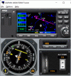
North up vs track up

Must be something about large cities.

Or weirdly designed ones. There’s very few surface streets that “look better” than all but the absolute worst traffic jams in Denver.

Bill just happens to live somewhere with incessant jams in the same place all the time and a neighborhood road that ends up minutes faster *at the speed limit* and Waze or Google routes the mob through his ‘hood.

We don’t let anything but major roads go through neighborhoods like that in “newer” cities, so this type of re-route is really rare. The jam has to be a complete standstill for a long time (closure) for the algorithms to choose winding roads with low speed limits and lots of stop signs and such.

Most of the time if you get off the highways here it becomes a “you can’t get there from here” problem for the auto-router.

My rural house really highlights this. There’s literally only two roads that can get here from town. If someone marks on blocked or closed, everyone is going the other way who’s using these types of maps. There’s a third way in, but it’ll take you 30 miles out of your way, is dirt, and impassible in wet or snow.
 
Or weirdly designed ones.
More about being older ones. Metro Denver is relatively new. Laid out like a grid in terms of major streets. You can get on some N-S streets and follow them for miles beyond Denver itself. I remember following one from Ft Collins to Denver. Same for the E-W ones.

East coast is older and more colonial. Horse and cart paths from a simpler time. Boston is a great example. A central gathering place - the Common - with streets laid out as spoke and wheel. Great city for walking. Horrible for driving.

But I was actually referring to the disregard of speed limits and stop signs.
 
Wrench in the works alert.
My Yaesu 750 radio has a GPS function..
It's nice, and works very well. The only "down" side is that you have to enter the GPS coordinates of any place you want to fly into the radio in advance.
The programming app makes that easier.
But..........
No magenta line. You point the airplane icon at the little ball and go.
Which makes it ..... BALLS UP.
 
Pink is the best color for course lines. Works best under NVGs, too.

You can get away with North up for large scale maps, but if you are navigating down in the treetops (and below), you'd better have that map lined up in the direction of flight. :frown3: :frown3:
Whatever works for you.

Personally, if I'm in the trees or below, I'm looking out the windscreen, not the map. Unless I have a HUD, and even then it's not on a map display.

YMMV.
 
My Garmin GPS has traffic. I used it a few times to reroute but the detour always seemed to take longer than just sitting in traffic. However, it did show me a back way out of/off Alameda that was faster than the normal route.
 
During the rest of my 182 check out yesterday, the chief pilot invited along a prospective flying club member (Hi Dave! Hope you joined POA too.) While we were wandering around, we were trying to find an airport and the passenger handed me his mobile phone with "track up". In the moment, I could not put my head around which way to fly to the airport. But today, in the light of hindsight, I think I could have figured it out if I had taken a breath to THINK. Hard to fly with two other people trying to tell you what to do.
 
Track up does have one actual benefit. If you are "on course" all you have to do is keep the magenta line VERTICAL.

Cheap HSI.
 
Track up when I'm low level in enemy territory, North up when I've crossed into friendly territory and climbing. Actually North up most times nowadays since it's easier to tell atc where I am in relation to a visual checkpoint: N1234 5 miles south of Castroville vs N1234 5 miles to the left of Castroville. Atc seems to prefer the former over the latter.
 
You know, I kind of wish I had a vertical card compass and/or heading indicator that remained stationary with north up, and the needle moved to point to my course/heading... ;)

They had those. I "think" it was called an electric compass. Think WWII
 
Track up when I'm low level in enemy territory, North up when I've crossed into friendly territory and climbing. Actually North up most times nowadays since it's easier to tell atc where I am in relation to a visual checkpoint: N1234 5 miles south of Castroville vs N1234 5 miles to the left of Castroville. Atc seems to prefer the former over the latter.

Good illustration of how either way you do it you’re going to have to be able to ‘think’ to have situational awareness.
 
Track up when I'm low level in enemy territory, North up when I've crossed into friendly territory and climbing. Actually North up most times nowadays since it's easier to tell atc where I am in relation to a visual checkpoint: N1234 5 miles south of Castroville vs N1234 5 miles to the left of Castroville. Atc seems to prefer the former over the latter.

I can see that. All ATC's scopes are oriented North.
 
When I started to fly North Up was confusing for me as a student pilot and even for some time after I got my PPL. As a VFR pilot you “map-fly” a lot. But I think in IFR North Up is better. You can visualize holds and cross reference charts better.
 
Pink is the best color for course lines. Works best under NVGs, too.

You can get away with North up for large scale maps, but if you are navigating down in the treetops (and below), you'd better have that map lined up in the direction of flight. :frown3: :frown3:

Exactly. I did north up for charts, until it came to low level. At 480 knots at 500 feet or possibly below (so I have been told that sometimes it might be lower than 500 feet), you really want a strip chart that is oriented track up for each leg.
 
My favorite Waze story is about going to a concert. All of a sudden, Waze goes, "I have a better route. Turn left at [next intersection]. Turns out there was an accident and a tie-up a few miles up. With Waze we lost all of three minutes. Did that - routing us around a sudden traffic tie-up - many times. Crowd-sourced traffic is what makes it worth using. In addition to being smart enough to know the shortcuts.

OTOH, so many people have Waze or similar, that ignoring it and going the way you originally planned can be faster as everyone jumps off the main road and clogs up the side roads.
 
OTOH, so many people have Waze or similar, that ignoring it and going the way you originally planned can be faster as everyone jumps off the main road and clogs up the side roads.
True. Waze will change routes for a very small amount of time savings. Even without everyone heading there, the normal ebb and flow of traffic changes this stuff.
 
Man, this guy signed up just to resurrect a 5 year old thread.

(Track up on the GPS, north up on the iPad. Obviously.)
 
Maybe they were still lost? Like the legend of the guy driving left around the Pittsburgh beltway for 20 years, because he couldn't figure out a way out?

Don't look too hard for background on the legend, I just made it up.
 
My brother lives in Jamaica Plain, I can confirm the story is plausible. Sending the link along to him.

I hadn't heard that before, though. My inspiration was being stuck going in circles around Pittsburgh on one of the different colored "belts" as a kid in the back of a Chevy Caprice for about 2 days one summer afternoon. My only comment then was an answer to the question "haven't we been through here before?" with "several times actually", which was apparently only funny to that same brother and me. An advantage of the size of the Caprice is that you couldn't drive and hit a kid in the back corner at the same time.
 
For all of you that use an HSI ...

When properly configured, it's a Track Up presentation.

HSI as North Up.gif
 
Back
Top