You are using an out of date browser. It may not display this or other websites correctly.
You should upgrade or use an alternative browser.
You should upgrade or use an alternative browser.
Has New York Gone Under?
- Thread starter Lawreston
- Start date
Keane
Pre-takeoff checklist
Haha, New York has always been the underground sewer of the country ")
I recognize that area, that is right on Copley, isn't it?
I recognize that area, that is right on Copley, isn't it?
Lawreston
En-Route
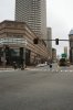
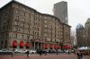
Yeah; November 13, while I was standing just across Dartmouth St., looking between The Westin Hotel and Boston Public Library. When I was in college in 1962 and after, I'd get off the New Haven RR at Back Bay Station(just out of the left side of my photo) and walk up Huntington Avenue. The old buildings were being demolished on Dartmouth; the turnpike was being built under Copley Square; and the Prudential Tower was yet a tall structure of I-Beams with the famed Native Americans riding on those suckers high up and away. Boston is one of the great cities of the world. I hadn't been back to just walk around and photograph in at least 30 years.
HR
HR
flyersfan31
Touchdown! Greaser!
- Joined
- Mar 31, 2006
- Messages
- 14,269
- Display Name
Display name:
Freiburgfan31
That's funny.
Lawreston
En-Route
I recognize that area, that is right on Copley, isn't it?
Having mentioned The Prudential Tower and Huntington Avenue, photo #1 shows parts of each. And to my back, as I took that image, was Trinity Church Episcopal(built in 1876) shown facing into the "new" John Hancock Tower(http://www.aviewoncities.com/boston/hancocktower.htm)
HR
Attachments
TMetzinger
Final Approach
MASS PIKE WEST!!!! I lived and studied there in the mid-late 80's... Used to walk over Mass Ave and look down at the Mass Pike and count the days until I'd be driving back home.
Good memories
Good memories
Keane
Pre-takeoff checklist
Those are great pictures! I recognized the area, we walked that area quite a bit when I was in school (Class of '07). I attended college in the Fens though, so we didn't make it to that area all that often.
Lawreston
En-Route
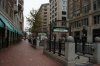
When I was in Radio/Television/Theater school I lived on Carleton Street, Brookline. Going to/from class I walked(rode unicycle) across the footbridge and through the Fens, across the crazy intersection near the BIG Sears store, and past Simmons College toward State College at Boston(now Massachusetts College of Art). I noticed yesterday that Carleton Street hasn't changed; The BUSY BEE Restaurant is still in the same place at the Carleton/Beacon Streets intersection; but the referenced footbridge is cordoned off and no longer passable.
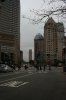
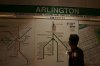
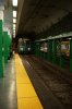
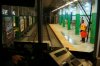
Photo #1: self-explanatory; #2: Inside the station; #3: E Train is my need for
Brigham Circle; #4: Under Copley Square.
HR
Photo #1: self-explanatory; #2: Inside the station; #3: E Train is my need for
Brigham Circle; #4: Under Copley Square.
HR
Attachments
Last edited:
Keane
Pre-takeoff checklist
Heh, I went to Wentworth, so I spent a ridiculous amount of time on the E train. I've been to the Arlington station quite a few times, we'd take the train to the Pru every once in a while to get to things up there.
TMetzinger
Final Approach
I am SOOO homesick for Boston now.
bbchien
Touchdown! Greaser!
I always wanted to stay there after college. Alas!
- Joined
- Jun 7, 2008
- Messages
- 24,361
- Display Name
Display name:
Bob Noel
I am SOOO homesick for Boston now.
if it helps, think about how bad Massport makes flying at
their airports.
It's not anywhere near as bad as the DC3 pilots have it, but it
still ****s.
Lawreston
En-Route
I am SOOO homesick for Boston now.
Here are a few more memories for you.
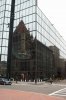
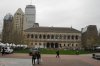
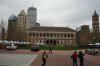
#1 = Copley Hotel(seems to me the old Copley Plaza may now be known as Fairmont Copley Plaza)[but I didn't look that closely].
#2 = Public Library of Boston
#3 = Public Library w/ Old South Church(tower only) on the right
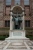
#4 = Monument at the side of Trinity Church
HR
Attachments
Last edited: