You are using an out of date browser. It may not display this or other websites correctly.
You should upgrade or use an alternative browser.
You should upgrade or use an alternative browser.
Georeferenced Approach Plates
- Thread starter jmptexas
- Start date
gismo
Touchdown! Greaser!
I have Jepp plates on my EX500 MFD. They are geo referenced to the extent that the airplane symbol moves around the chart. On a Garmin MX20 or GMX200 the charts move with the airplane at a fixed location on the display. What did you want to know?Does anyone have experience with both Jepp georeferenced approach plates and NOS plates on cockpit displays?
That almost tells me what I need to know. I'm having a G500/G600 unit installed in my C340A. I already have a pair of GNS 430s. The shop suggests the enabling card to use Jepp georeferenced plates. I'm okay with that, but I'm one of those wierd pilots who navigates with all charts and plates oriented north-up. If the georeferenced plate is going to show track-up, I don't want it. It would be too confusing to mentally jump back and forth between north-up and track-up.
I emailed Jepp, and got a vmail reply. The accent was very heavy, hard to understand. What I think he said is that the georeferenced plates will only display "correctly", so I'm assuming that means track-up.
So, longwinded question - do you know if the Jepp approack plates will display north-up?
I emailed Jepp, and got a vmail reply. The accent was very heavy, hard to understand. What I think he said is that the georeferenced plates will only display "correctly", so I'm assuming that means track-up.
So, longwinded question - do you know if the Jepp approack plates will display north-up?
Everskyward
Experimenter
- Joined
- Mar 19, 2005
- Messages
- 33,454
- Display Name
Display name:
Everskyward
Jepp approach plates display north up. We have them in our plane.do you know if the Jepp approack plates will display north-up?
Jepp approach plates display north up. We have them in our plane.
Just to be sure I get it ....
As you look at the approach plate on your display, it is north-up, just as if you were reading the paper plate from the book. As you fly an approach (for example, to runway 13), the plane in the screen would be facing the 4 o'clock position, and the chart would move left and up as the approach proceeded.
Correct?
Everskyward
Experimenter
- Joined
- Mar 19, 2005
- Messages
- 33,454
- Display Name
Display name:
Everskyward
That's partly true. The chart is north up, just like reading the plate from a book. The if the plane is moving SE the nose of the symbolic plane is pointing southeast. However the the chart does not move to keep the plane centered. You can zoom in on the chart to make it bigger so you can read the writing more easily but then only part of the chart is showing so you need to scroll left/right or up/down to see the part of the chart in which you are interested.Just to be sure I get it ....
As you look at the approach plate on your display, it is north-up, just as if you were reading the paper plate from the book. As you fly an approach (for example, to runway 13), the plane in the screen would be facing the 4 o'clock position, and the chart would move left and up as the approach proceeded.
Correct?
Sorry to keep beating this horse, but now I'm confused. If the plate doesn't move, and the airplane doesn't move from the center of the screen, that doesn't sound georeferenced. I understoof that in the georeferenced application, the plane is always correctly positioned on the screen, relative to where you actually are on the approach.
Everskyward
Experimenter
- Joined
- Mar 19, 2005
- Messages
- 33,454
- Display Name
Display name:
Everskyward
The symbolic airplane moves and is not in the center of the chart. It's like watching a little green airplane fly across the chart. The position of the airplane on the chart is correct but it (the airplane) is not necessarily in the center of the screen.Sorry to keep beating this horse, but now I'm confused. If the plate doesn't move, and the airplane doesn't move from the center of the screen, that doesn't sound georeferenced. I understoof that in the georeferenced application, the plane is always correctly positioned on the screen, relative to where you actually are on the approach.
Okay, I get it now. So in approach plate mode, the plane moves. In enroute moving map mode, the map moves, just like on my 430?
I have also been told that the NOS charts won't do this georeferenced mode, but that maybe NOS is working on that for next year. Have you heard that?
I have also been told that the NOS charts won't do this georeferenced mode, but that maybe NOS is working on that for next year. Have you heard that?
Everskyward
Experimenter
- Joined
- Mar 19, 2005
- Messages
- 33,454
- Display Name
Display name:
Everskyward
Yes.Okay, I get it now. So in approach plate mode, the plane moves.
We don't have any enroute maps unless you count SIDS and STARS. The airplane symbol doesn't show up on them, they are just the charts.In enroute moving map mode, the map moves, just like on my 430?
I have found that the most useful aspect of the whole system is the airport diagrams which show the symbolic airplane. It makes it much easier to taxi around unfamiliar airports.
I don't know anything about the NOS system.I have also been told that the NOS charts won't do this georeferenced mode, but that maybe NOS is working on that for next year. Have you heard that?
Everskyward
Experimenter
- Joined
- Mar 19, 2005
- Messages
- 33,454
- Display Name
Display name:
Everskyward
Truthfully learning how to use all the functions of this system has been trial and error.Thanks. This helps a lot. Apparently you know more about the Jepp products than Jeppesen does. :smile:

- Joined
- Feb 23, 2005
- Messages
- 11,222
- Location
- Lone Jack, MO
- Display Name
Display name:
Greg Bockelman
Truthfully learning how to use all the functions of this system has been trial and error.
Out of curiosity, where is the information displayed? Is it on one of the forward screens? What is used for actual navigation?
Everskyward
Experimenter
- Joined
- Mar 19, 2005
- Messages
- 33,454
- Display Name
Display name:
Everskyward
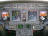
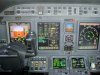
The charts are displayed on DU-3 which is the third large screen from the left. Unfortunately I don't have a picture with the charts displayed. You can see (I hope) at the top of the screen a row of buttons. the second one from the right says CHART. Obviously when you have the chart displayed it obscures anything else you want to see on that screen since it fills the screen. We can't use this as an EFB and we need to have backup paper charts. We used the taxi diagram feature from the beginning when we got the airplane. Now we almost always put up the approach chart feature when doing an approach although sometimes we will switch back and forth with MAP, which is what is depicted in the photograph. Like I mentioned, this was a trial and error process. We got this airplane and the charts were installed so we had to figure out how to use them in the most logical way since it was not something taught at skool. Not all these airplanes have the charts installed.Out of curiosity, where is the information displayed? Is it on one of the forward screens? What is used for actual navigation?
Attachments
The G500/G600 is a panel-mount PFD/MFD. The plates are shown on the right half (the MFD side). The geo-position info comes from the GPS unit. The approach plate info comes from a separate data card for the plates, which also includes taxi diagrams and AOPA airport directory info. The unit comes with NOS plates already installed. The Jepp georeferenced plates require an upgrade card ($2400) plus an annual Jepp subscription.
Everskyward
Experimenter
- Joined
- Mar 19, 2005
- Messages
- 33,454
- Display Name
Display name:
Everskyward
It's a CE-680 (Citation Sovereign).Wow, that's some panel. What kinid of plane is it?
- Joined
- Feb 23, 2005
- Messages
- 11,222
- Location
- Lone Jack, MO
- Display Name
Display name:
Greg Bockelman
Two more questions. Can that be displayed on any of the four screens, and in your operation, is the pilot flying always in the left seat?
Everskyward
Experimenter
- Joined
- Mar 19, 2005
- Messages
- 33,454
- Display Name
Display name:
Everskyward
The two middle screens (DU-2 and DU-3) can be swapped although we never do it. As far as flying from the right seat, the guy who is SIC only flies from the right when there are passengers although we let him fly from the left when we are empty. When myself and the other captain fly together the flying pilot sits in the left no matter who is designated PIC on that flight. Is that clear as mud?Two more questions. Can that be displayed on any of the four screens, and in your operation, is the pilot flying always in the left seat?
TMetzinger
Final Approach
On this topic... I've flown with both Jepp and NACO on the G1000, and I feel that with the Jepp charts having the airplane moving on the chart may distract me somewhat from paying attention to the raw data on the PFD, sort of like the "Magenta Line of Death". It's not a huge issue, just something that makes me pause in my scan sometimes. With the NACO charts, I often brief the approach, then leave the MFD in the moving map/flight plan split screen. The flight plan shows the altitude constraints, the moving map gives me the situational awareness, but doesn't seem to distract as much. I find that I don't need to refer to the plate during the final approach, even on the initial miss.
But with all this automation comes a pretty high amount of flexibility so that individual pilots under 91 can set things up in a way that suits them. 135 operators may have the cockpit setup procedures specified for them - I don't know.
But with all this automation comes a pretty high amount of flexibility so that individual pilots under 91 can set things up in a way that suits them. 135 operators may have the cockpit setup procedures specified for them - I don't know.
Everskyward
Experimenter
- Joined
- Mar 19, 2005
- Messages
- 33,454
- Display Name
Display name:
Everskyward
In our case since we were the first 3 and only 3 pilots to fly this airplane we got to figure out and write our own SOPs. No one else in the company knows a thing about it. That doesn't mean there weren't some, um, conflicting opinions about how to do things.135 operators may have the cockpit setup procedures specified for them - I don't know.
TMetzinger
Final Approach
In our case since we were the first 3 and only 3 pilots to fly this airplane we got to figure out and write our own SOPs. No one else in the company knows a thing about it. That doesn't mean there weren't some, um, conflicting opinions about how to do things.
Lemme see.... 3 pilots > 27 opinions.
Metzinger's fifth law of pilots: The minimum number of opinions is expressed as the number of pilots raised to the (number of pilots) power.
Last edited:
Everskyward
Experimenter
- Joined
- Mar 19, 2005
- Messages
- 33,454
- Display Name
Display name:
Everskyward
Lemme see.... 3 pilots > 27 opinions.
Metzinger's fifth law of pilots: The number of opinions is expressed as the number of pilots raised to the (number of pilots) power.

Greg - the answer regarding the Garmin G500/600 is somewhat different. It can only be flown with the PFD on the left screen. The MFD side (right) is where all the charts, plates, weather, traffic, etc are displayed. Garmin also has a synthetic vision option for another $5k on the G500, standard on the G600.
Aspen has a setup for Class 1 & 2 planes. Those are separate modules, so I suppose you could mix and match them as you want. There may be some legal implications in that.

Aspen has a setup for Class 1 & 2 planes. Those are separate modules, so I suppose you could mix and match them as you want. There may be some legal implications in that.
- Joined
- Feb 23, 2005
- Messages
- 11,222
- Location
- Lone Jack, MO
- Display Name
Display name:
Greg Bockelman
Is that clear as mud?
Very clear. When the SIC flies from the right seat, do you swap the display to DU-2 from DU-3?
Everskyward
Experimenter
- Joined
- Mar 19, 2005
- Messages
- 33,454
- Display Name
Display name:
Everskyward
No, but remember our cockpit is a lot skinnier than yours so it isn't a long way to look over at something on the other side.Very clear. When the SIC flies from the right seat, do you swap the display to DU-2 from DU-3?
")
- Joined
- Feb 23, 2005
- Messages
- 11,222
- Location
- Lone Jack, MO
- Display Name
Display name:
Greg Bockelman
No, but remember our cockpit is a lot skinnier than yours so it isn't a long way to look over at something on the other side.
Be that as it may, why not swap it so the Flying Right Seater doesn't HAVE to look cross cockpit? In my world, looking cross cockpit would not be allowed for "safety" reasons.
Everskyward
Experimenter
- Joined
- Mar 19, 2005
- Messages
- 33,454
- Display Name
Display name:
Everskyward
So then I guess the EICAS display is more important to look at than the MFD? It seems to me that once you get used to seeing something in a certain place it would be less "safe" to keep moving it around. We switched it around once just for grins and it didn't look right, or normal.Be that as it may, why not swap it so the Flying Right Seater doesn't HAVE to look cross cockpit? In my world, looking cross cockpit would not be allowed for "safety" reasons.
- Joined
- Feb 23, 2005
- Messages
- 11,222
- Location
- Lone Jack, MO
- Display Name
Display name:
Greg Bockelman
Hmm. I THINK what we have here is a failure to communicatel
That would be the left hand screen on the FO's side, correct? Do you display that during the approach? For situational awareness?
Where do you display the EICAS when the approach chart is displayed?
If you have an issue that is normally displayed on the screen where the approach plate is being displayed, how do you know? Does it get displayed elsewhere?
Exactly. I don't know how the "Raw Data" for the approaches is displayed, but I would think that it would be best displayed in front of the pilot flying. If the map is always displayed on DU-3, does that mean you have to look cross cockpit for that info?
Another question, where is the EICAS info normally displayed?
I am just trying to understand. My point of reference is Boeing and Airbus glass where there are actually 6 displays. EICAS info is actually displayed on two screens in the middle of the panel where your standby instruments are. Just trying to learn.
The charts are displayed on DU-3 which is the third large screen from the left.
That would be the left hand screen on the FO's side, correct? Do you display that during the approach? For situational awareness?
So then I guess the EICAS display is more important to look at than the MFD?
Where do you display the EICAS when the approach chart is displayed?
Obviously when you have the chart displayed it obscures anything else you want to see on that screen since it fills the screen.
If you have an issue that is normally displayed on the screen where the approach plate is being displayed, how do you know? Does it get displayed elsewhere?
It seems to me that once you get used to seeing something in a certain place it would be less "safe" to keep moving it around.
Exactly. I don't know how the "Raw Data" for the approaches is displayed, but I would think that it would be best displayed in front of the pilot flying. If the map is always displayed on DU-3, does that mean you have to look cross cockpit for that info?
Another question, where is the EICAS info normally displayed?
I am just trying to understand. My point of reference is Boeing and Airbus glass where there are actually 6 displays. EICAS info is actually displayed on two screens in the middle of the panel where your standby instruments are. Just trying to learn.
Last edited:
- Joined
- Feb 23, 2005
- Messages
- 11,222
- Location
- Lone Jack, MO
- Display Name
Display name:
Greg Bockelman
Mari, do you fly with the displays set up as they are in the pics? With the EICAS stuff on DU-2 and the map on DU-3? I personally would want to do it the other way around. But that is how I have done it in the Boeings for the last 21 years.
Everskyward
Experimenter
- Joined
- Mar 19, 2005
- Messages
- 33,454
- Display Name
Display name:
Everskyward
Yes.That would be the left hand screen on the FO's side, correct?
Yes. We have started doing that.Do you display that during the approach? For situational awareness?
We always have the EICAS in DU-2 (second screen from the left)Where do you display the EICAS when the approach chart is displayed?
The only thing that would cancel the chart and then display on DU-3 would be a TCAS alert. The TCAS display would automatically pop up.If you have an issue that is normally displayed on the screen where the approach plate is being displayed, how do you know? Does it get displayed elsewhere?
I see where you are probably confused. You can't see it in the picture but underneath the flight director display on both the right and left sides is an HSI. Actually we can go to ARC and display the waypoints down there too, but everyone I fly with uses the HSI display. You can see the HSI in this picture.Exactly. I don't know how the "Raw Data" for the approaches is displayed, but I would think that it would be best displayed in front of the pilot flying. If the map is always displayed on DU-3, does that mean you have to look cross cockpit for that info?
I don't think 6 screens would fit in our panel!I am just trying to understand. My point of reference is Boeing and Airbus glass where there are actually 6 displays. EICAS info is actually displayed on two screens in the middle of the panel where your standby instruments are. Just trying to learn.
Haha. I was told that for some reason pilots who some to the Sovereign from the Citation X like to reverse the displays but since this is our first all-glass airplane we just do it the default way.Mari, do you fly with the displays set up as they are in the pics? With the EICAS stuff on DU-2 and the map on DU-3? I personally would want to do it the other way around. But that is how I have done it in the Boeings for the last 21 years.
Attachments
- Joined
- Feb 23, 2005
- Messages
- 11,222
- Location
- Lone Jack, MO
- Display Name
Display name:
Greg Bockelman
We always have the EICAS in DU-2 (second screen from the left)
Man, whatever works. But as flying pilot, I would want the map in front of me and the EICAS cross cockpit. I reference the map as much as anything else in the cockpit, and more so than the EICAS.
I see where you are probably confused.
Not confused, really. Just curious.
I don't think 6 screens would fit in our panel!
Granted, just a point of reference. Besides, you have seen first hand how ours are set up.

Haha. I was told that for some reason pilots who some to the Sovereign from the Citation X like to reverse the displays but since this is our first all-glass airplane we just do it the default way.
Whatever works.
Everskyward
Experimenter
- Joined
- Mar 19, 2005
- Messages
- 33,454
- Display Name
Display name:
Everskyward
I reference the map more when the radar or terrain display is up or there is traffic but if it's just the map I think I only glance at it occasionally for reference and if one thing is going to be hidden by the chart I would rather have it be the map than the EICAS. In thinking about it, it's only been 5 or 6 years since I have had access to a moving map at all. The old Lears didn't have any moving map when I first started flying them. It was only later that they installed MFDs. Of course now I am spoiled. I think that's part of the reason I have trouble relating to the "magenta line" problem. It would never occur to me to steer the airplane in reference to it.I reference the map as much as anything else in the cockpit, and more so than the EICAS.
That's true!Besides, you have seen first hand how ours are set up.
It was interesting to me to try to figure out what some of the display elements meant on your map, especially that dashed line. I think your map is a little more sophisticated than ours.