Catalina and basic pattern questions

MountainDude

Cleared for Takeoff
PoA Supporter
Joined
Jul 29, 2011
Messages
1,018
Display Name

Display name:
MountainDude
Hoping to visit Catalina in December with my 182.
Must be VFR, so hoping for no fog.
We like nature, so interested in hiking, kayaking, and photography.

- Daytrip or overnight?
- We will likely have our camping gear but dont mind paying for a hotel if there is something really nice about it. Any recs for a campground or hotel?
- How much is the taxi into Avalon or Little Harbor for 3 people and light luggage?

Aviation-related, I read the guide for pilots here:
https://www.catalinaconservancy.org/index.php?s=visit&p=pilot_information
and there are two pieces of info new to me:
1. Straight-ins are discouraged and must yield to aircraft on 45 degree to Downwind through Final.
2. Straight–ins result in high % of go-around.

Comments?
 
The view from a pilot standing on the ground. I had gone there by boat.

The ceiling was about 100 feet, the trucks were waiting for the cargo C 47. I doubted it would come, then it was there. Talked to the pilot, he said that he called the airport to find the ceiling, and flew 500 under until just a mile or so out, then climbed just high enough to clear the terrain, crossing the end of the runway at 10 feet, chopped power, and set down,

He indicated that all landings with ceiling below 500 feet were straight in, with radio calls to assure that there was no other plane doing the same from the opposite end.

Flat cloud decks indicate no wind, of course, so either way works, but the normal arrival is from the mainland, so opposite traffic arriving is rare. Departing traffic, on the other hand tends to take of toward the mainland, so you could meet them. The C 47 took off toward shore, opposite to his landing.

Use Google earth to determine the orientation of the runway relative to the small ops building to be sure that you arrive at the end of the runway, and aligned.

Catalina is an interesting place, and camping on the airport might be possible. The surrounding area is quiter interesting, watch out for the buffalo, they are not friendly. There is a shuttle bus to and from the airport at regular intervals, check the schedule. I do not think there is a taxi available.
 
Hoping to visit Catalina in December with my 182.
Must be VFR, so hoping for no fog.
We like nature, so interested in hiking, kayaking, and photography.

- Daytrip or overnight?
- We will likely have our camping gear but dont mind paying for a hotel if there is something really nice about it. Any recs for a campground or hotel?
- How much is the taxi into Avalon or Little Harbor for 3 people and light luggage?

Aviation-related, I read the guide for pilots here:
https://www.catalinaconservancy.org/index.php?s=visit&p=pilot_information
and there are two pieces of info new to me:
1. Straight-ins are discouraged and must yield to aircraft on 45 degree to Downwind through Final.
2. Straight–ins result in high % of go-around.
Comments?

1. That’s the rules, if you are straight in, you are not disrupt the traffic pattern.
2. The go around is from pilots not slowing down coming over the water and being to high/ fast on approach.
 
Last edited:
#1 is a local operational statement. The part about yielding to traffic in the "normal" is supported by other FAA guidance too.

#2 sounds like a statement based on experience. The airport is cut out of a mountain with many of the features, illusions, and operational requirements of a mountain airport (sans high D-Alt). Long straight ins can be difficult for pilots to gauge. Seeing the full runway environment from a downwind position enhances situational awareness. More so for the uninitiated to airports like that. It's probably still true local flight schools require a "Catalina checkout" for a reason.
 
Here's a video I took a few years ago. Bump ahead to about 4 min. I usually fly overhead and turn downwind coming from the east. People are usually pretty polite about coordinating arrivals here.


The main problems people seem to have is judging the glide path because of the rapid terrain drop off at the end of the runway, and the hump in the middle of the runway makes people worry about how much runway is left because you can't see the other end.

If I remember right round trip on the bus to Avalon is about $35 per person. There is a camp ground at little harbor (bus ride), but I'd find a hotel in Avalon.
 
Here's a video I took a few years ago. Bump ahead to about 4 min. I usually fly overhead and turn downwind coming from the east. People are usually pretty polite about coordinating arrivals here.

...

DAYUM that was a FINE JAM in that video! holy cr@p I was digging that!
 
When I lived in Torrance and flew out of TOA, the standard way to get to AVX was to fly to Two Harbors and then turn towards AVX and enter a right downwind for Runway 22. I never landed on 4 as the winds never seemed to favor it. I made the trip several times and personally never found the approach difficult. One key is that as you enter the downwind to get the lay of the land, get a good approximation of how far down the runway the taxiway exits and terminal are, and make note of how much runway remains past the skid marks. Do this and there will be no surprises. Then just fly a stabilized approach, hitting your airspeeds, and you will have no problems.

Bonus: On the way across the channel, keep an eye out for whales navigating their way through it. Saw a few gray whales a couple of times and a huge blue one time. Amazing sight.
 
My wife and I flew from Tucson to AVX back in mid January. Winds were out of the NE so I came in on 4, which is not normal for there. The uphill part of 4 is much shorter than it is coming in from 22 so you don't want to come in high or fast or you will float too far over the downhill part to get stopped. We flew there for lunch and when I checked in with the guy in the tower he informed me that the restaurant, gift shop and museum were closed for renovation.... :eek: Nothing on their website about that. Fortunately my wife had brought plenty of snacks onboard, so we had a nice picnic in the nature center, walked around the airport area, shot lots of photos and headed home. The $35 landing fee was still requested, even with everything being closed... :rolleyes:
It was a very fun experience, even with the renovation closure surprise. In January there was no fog in the forecasts, so that is why we went that time of year. I wouldn't go in there in foggy conditions.
 
I never could figure out the big whip about Catalina. It's a 3K foot strip on an island. 89D is a 2200 foot strip on an island, and you often have to land over trees.
I agree. In normal conditions it is not a challenging approach. Landing on 22 with the long uphill, you can even land long and be ok. When SW winds are up it would even be a shorter roll. People must come in way too high and fast that have problems.
 
I never could figure out the big whip about Catalina. It's a 3K foot strip on an island. 89D is a 2200 foot strip on an island, and you often have to land over trees.
Methinks the “thing” about Catalina is that it’s just a cool bucket list type experience; landing there isn’t a challenge, but apparently some less talented drivers tend to screw it up and make it a big deal.

89D, Kelleys Island… and don’t forget Middle Bass and North Bass, both island airports with 1800’ paved. Fun! I’ve landed at all 4 of these island strips in my RV-8; I like ‘em all…
Yeah, I haven't landed either Middle or North Bass Islands. Not a whole lot there, and those strips are closing in on what's safe to land in the Mooney.
 
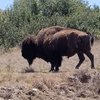
I was hiking there one day on the airport loop. This fellow was hanging out on the road not providing much space to get around him. I generally try to give these guys as much space as I can.

IMG_20210619_170026_457.jpg
 
I was hiking there one day on the airport loop. This fellow was hanging out on the road not providing much space to get around him. I generally try to give these guys as much space as I can.

View attachment 101979
Was this Bison photo shot on Catalina Island or where? I thought the don't feed the foxes sign at AVX was interesting and funny, but seeing this guy would have been really cool!
 
Was this Bison photo shot on Catalina Island or where? I thought the don't feed the foxes sign at AVX was interesting and funny, but seeing this guy would have been really cool!
Yep. Right on the airport loop trail.
 
That picture shows why there is a strong fence around the airport, and a cattle guard on the gate coming in.

Taking pictures of those guys is risky unless a telephoto lens is used, they are very near sighted, and seem to ignore people. When you get close enough that they see you, the may charge. I learned that from a ranger at Yellowstone, after taking a similar picture.

Yep. They're scary. Somebody spooked one once when I was in the area. The ground was shaking when that thing ran, and they aren't slow. We slid by this one very quietly. No tele photo.
 
Love Catalina, nice 4 mile hike around the airport do a couple dozen times a year.

Some weekends can be busy, don’t be the guy calling in a 5 mile straight in while there are a few of us accommodating each other and positioning ourselves.

Careful of wind-shear couple hundred feet off the deck with crosswinds picking up.
 
The cargo guy only did his straight ins with the ceiling below pattern altitude.
 
Back
Top