- Joined
- May 11, 2010
- Messages
- 20,703
- Location
- Charlotte, NC
- Display Name
Display name:
Snorting his way across the USA
I'm sure at some point stone etchings were considered the renaissance in aviation mapping.
Paper today is like NDBs back in the 2000s. You train with them a few times not to regularly use, but solely as an "if everything else fails" type of skill.When AOPA pushed the FAA to 56 day cycles for sectional charts that was the end for paper in pilot training.
I’m a big fan of a good index. Unfortunately authors and/or publishers seem to disagree more and more.and searchability doesn't help much when you haven't read any of the material.
Yup…tougher to post on Facebook while driving with paper maps.I suppose it's a bit like using a GPS vs a book of street maps when driving around.
I Know the services have gone EFBs but I don’t think they will ever get rid of paper. Especially for VFR nav. Gotta have back ups to fall on. Nav with a 1:50,000 map sux.I flew 2200 hours as an NFO with nothing but paper charts and a numbers only INS and eventually a numbers only GPS. That included thousands and thousands of miles on low levels at 480 KTS and 200’. An EFB is a wonder and would have made life a lot easier and allowed me to focus on other things that were going to keep us alive.
At some point a student needs to understand the benefits and pitfalls of the EFB. First X/C paper? Sure. Chart to ground correlation is important but students are being trained to be complete pilots. By the time the time they’re headed to the check ride they should be very familiar with their EFB. Same with geo-referenced approach plates when you move on to an instrument rating. I have not shot an instrument approach since the Navy with a paper plate. The EFB is another part of the scan and needs to be integrated into training.
I seem to always be flying near the edges of the page. A real PitA to flip the paper chart over everytime I go north of my home field and then back south.Got my Private in 2019, didn't touch an EFB until after the check ride and only used paper maps, which I would highly recommend for all students. Haven't used a paper map in the cockpit since then but do keep copies with me and still do use them for initial planning occasionally and just to look at sometimes. It's fun to lay a few out on a table and just "explore" all the airspace. Better than looking at the small ipad screen and constantly two-fingering around on it. But all my final flight plans come from an EFB, no reason not to utilize the technology and all the near-instant info it provides easily. If absolutely needed (highly unlikely but who knows), I'd be confident in my abilities to navigate in the air with paper charts and an E6B. Not sure how likely it is I lose all GPS sources and radios/VOR (I carry a handheld and extra batteries too) but certainly helps to have multiple backup plans.
Try refolding in an open cockpit.I seem to always be flying near the edges of the page. A real PitA to flip the paper chart over everytime I go north of my home field and then back south.
I hope they still teach studs how CHUM and to make strip charts and radar predictions but that’s just part of the pain package.I Know the services have gone EFBs but I don’t think they will ever get rid of paper. Especially for VFR nav. Gotta have back ups to fall on. Nav with a 1:50,000 map sux.

Yes there are pilots who have used only an EFB. (I’m an old guy. I used paper charts all the way until 2011!)A few weeks ago I had over of those "oh crap, I'm the old guy" moments when a another club member asked "Have you ever used paper maps before?".
The question was so foreign to me. Are there actually pilots who've only used electronic sectionals? How does one do the whole pilotage and DR stuff with a moving map? What about the handful of times your tablet will fail due to being in direct sunlight too long?
 ).
).I’m sure I’ve told this one before.Try refolding in an open cockpit.

They had them, they were just in 120' segments.The Wright Brothers.
I have sympathy that you didWhat really bothers me is that there are instrument rated pilots that never had to do a paper Jeppesen chart revision.
I'm on the fence. Definitely Aeronautical in flight when IFR. But VFR, I prefer the Sectional precisely because of all that detail. Related to my earlier comment about the benefits of using it for pilotage, I like looking at something on the chart and seeing it out the window. I just feel it gives me better situational awareness.I have my iPad, my iPhone, and my Garmin 430. If they all fail, I guess I can probably find an airport.
I hate sectionals so much, I don't even have them turned on when using Foreflight! I use the GPS mode "Aeronautical" view, which I feel provides all of the information I need without all of the clutter.
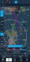
View attachment 124244
I think you're in the majority. I find all of my friends I fly with use the sectional view. In the GPS view, I see cities, roads, lakes, towers, etc. This gives me a pretty good visual reference.I'm on the fence. Definitely Aeronautical in flight when IFR. But VFR, I prefer the Sectional precisely because of all that detail. Related to my earlier comment about the benefits of using it for pilotage, I like looking at something on the chart and seeing it out the window. I just feel it gives me better situational awareness.
USN dropped celestial nav. Then decided, hmmm, what will we do is someone takes out the GPS sats??? So they are back to teaching and practicing it.I Know the services have gone EFBs but I don’t think they will ever get rid of paper. Especially for VFR nav. Gotta have back ups to fall on. Nav with a 1:50,000 map sux.


I did that once. Amd immediately switched to government plates.What really bothers me is that there are instrument rated pilots that never had to do a paper Jeppesen chart revision.
They are truly blessed.What really bothers me is that there are instrument rated pilots that never had to do a paper Jeppesen chart revision.
Ah but that's not quite accurate. They (we) all use STELLA...a computer software that does the math for you. You select which object you're shooting, you enter the time of your observation and your azimuth and it draws the line. Once you have enough lines, it draws the oval and gives you the lat/long. Nobody, and I mean NOBODY who isn't an old-school QM is doing the math on paper. I'm only speaking for the Navy and Coast Guard. I'd be shocked if the Merchant Marine doesn't have something similar.USN dropped celestial nav. Then decided, hmmm, what will we do is someone takes out the GPS sats??? So they are back to teaching and practicing it.
I did a bridge tour of a cruise ship. They had a sextant. I asked if they ever used it. Yeap, they did a sight a day to keep in practice.
Backups are good.
My favorite scene in that whole movie.I'm sure there are, but not if you were one of my students.
I use paper sectionals for training PPL. My philosophy is you need to understand the process before relying on the electronic. Otherwise you may not recognize when the electronic gives you rubbish.
I ran into this recently using Foreflight while planning a trip. I was planning about a 1.5 hour cross country in a Citabria on Foreflight, and noticed my expected fuel burn was 96 gallons. That obviously is problem when the Citabria only holds 36 gallons. It took a little digging to find the performance numbers for the aircraft in Foreflight, either a bug or fault of my own not sure, had an extra zero on the taxi/takeoff numbers.
I can tell you my students seemed to actually enjoy the experience though. Many are amazed to fly a cross country with a compass, a stopwatch, and a map, and it actually works. They get excited to see the next landmark come into view, and even more when they nail the timing between landmarks. Certainly more fun than direct-enter-enter, follow the magic line. Maybe less practical, but more fun.View attachment 124245
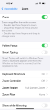
Solution for temporary enlargement of text (on an iPad/iPhone)... three finger double tap:My biggest gripe about EFBs are that when you pinch the screen to make the picture bigger so you can see the tiny print, the print adjusts itself back to tiny. I hate that.

Thank you! I have exactly the same gripe, and even more so with phone mapping programs - zoom in to see the street name. The street and surrounds all zoom in, and then the name is refreshed in the same tiny font! The base map in FF will zoom in as it's a digital representation of paper. So you can read the ASOS and so forth off the chart after zooming. But the "aeronautical" layer will not, so zooming in on the drop zone to see what it's extents are just gives a bigger circle with the same tiny fonts on the periphery.I used paper charts for the first 30 or 40 years but I have not touched a paper chart in the last 10.
My biggest gripe about EFBs are that when you pinch the screen to make the picture bigger so you can see the tiny print, the print adjusts itself back to tiny. I hate that.
Yeah, it’s a new age. My daughter started fly awhile back and of course everything was on her IPad. One day while thinking I’d see what she knows, I said , hey go grab a sectional and let talk about some of the things on there. Her reply, “what’s a sectional?” We decided to go to the mall and shop instead….A few weeks ago I had over of those "oh crap, I'm the old guy" moments when a another club member asked "Have you ever used paper maps before?".
The question was so foreign to me. Are there actually pilots who've only used electronic sectionals? How does one do the whole pilotage and DR stuff with a moving map? What about the handful of times your tablet will fail due to being in direct sunlight too long?
It's funny cause I carry them solely as a backup, but usual go through cycles without opening then even onceYeah, it’s a new age. My daughter started fly awhile back and of course everything was on her IPad. One day while thinking I’d see what she knows, I said , hey go grab a sectional and let talk about some of the things on there. Her reply, “what’s a sectional?” We decided to go to the mall and shop instead….
I remember doing an IPC with the chief instructor of the flight school at my home base. I stuffed the latest Jeppesen revision in my binder that morning.What really bothers me is that there are instrument rated pilots that never had to do a paper Jeppesen chart revision.
IERW students still make and navigate by the old Australian fold 1:50K!!!
