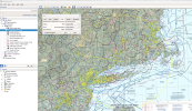
You can use Skyvector. It takes some time but it works... (the same method works with foreflight too)
Lets say I was looking to do a 50NM radius around airport Philadelphia international
Go to flight plan mode. Put KPHL airport in as the origin and destination. In the “route” section you can put KPHL360050 to get the point that is due north and a distance of 050nm from KPHL, next waypoint do KPHL010050 and continue in 10 degree increments until you reach 360 again.
If you want you can also have it draw out concentric circles for other distances by just continuing to add points at further distances.
You can use whatever heading increment you want depending on how coarse/fine you want the circle to be and how much you want it to look like a circle; I find 10 degrees works fairly well though occasionally if I have an airport on the line, when I measure it, it comes up short (especially as you get further out and as the airport gets closer to being between the 2 heading based fixes) but 10 degrees increments make it real easy to do a find/replace in a notepad on all 37 waypoints (360 is entered twice) and extend the distance as I can search for 0<old distance> (0050) and replace it with 0<new distance> (say 0100).
You can also use any waypoint point you want as long as it has an identifier that skyvector is aware of (airports, VORs, intersections, non-intersection waypoints, VP waypoints, etc).
I'll use the feature for distance when calling up a tower and am told to report "X mile final" I'll create a quick flight plan from "current location" to Airport, Runway Reciprocal Heading and distance and finally the airport
So if I were landing 09 at KPHL I'd put in KPHL270010 for a 10 NM final to 09.
There’s also ways to log a change to altitude or airspeed enroute.


