Any tips to better familiarize direction, degrees & headings?

LAWYER2

Filing Flight Plan
Joined
Dec 16, 2022
Messages
23
Display Name

Display name:
LAWYER2
Hey all,

Admittedly, I'm still struggling with quickly processing degrees and headings along with directions. For example, I'll know that the wind is coming from 240, yet still struggle to understand how it affects my direction or how it relates to the cardinal directions (North, South, East, West). I've experimented with using an INOP VOR gauge in the past to quickly adjust and figure out bearings, headings, and directions, but it can be distracting and not always available in the planes I fly. Another example is quickly being able to decide what runway to land on based on the wind direction from ATIS/AWOS at un-towered airports. I'm not sure why I still struggles with this, but if there is anything anyone suggests to better train my brain I would greatly appreciate it!
 
Do you remember geometry? (I didn’t ask if you liked it, lol). Remember 90 degree angles? Just think of a pizza with 4 big slices, start from the top with zero and go clockwise. Which quadrant or slice of pizza are you or the wind coming from or heading?

If you can’t math in 90s, how about 100s? It starts to get sloppier as you head west or northwest, so you can generally fake for a few seconds with the yoke it until your brain catches up. This is where a slow plane helps :)
 
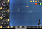
This app was made for playing with ifr navigation instruments, but it might help you visualize the compass and wind effects.


For example, I put a wind from 079 @ 17 knots in by clicking on the wind sock (now it’s a white circle on the top right displaying the current winds), and then flew the four cardinal directions and you can see the result.

IMG_0508.png
 
This is where learning to work the wind side of an E6B helped students get a feel for these issues. Electronic calculators give you a number. The E6B gives you numbers but also helps you visualize, because you are drawing the wind triangle. There are any number of gizmos in the Pilot Shops that do the same thing as the E6B but more intuitively https://www.sportys.com/runway-selector.html .

I used to draw a simple compass rose on my knee pad, sketch in the runway, and then draw a wind arrow before arriving at the airport. This used to be done from the weather briefing you got from Flight Services, now we have have up to the minute numbers with the AWOS/ATIS broadcasts. I still frequently overfly an untowered airport at 1k above pattern altitude to check the wind and get an idea of the lay of the land. (Then don’t be jerk. Be sure to fly well away from the pattern, descend to pattern altitude and make a regular entry).

Enroute, I’ve been impressed by how much my plane is more a “leaf with an engine” than other planes I’ve flown. The crab angles sometimes seem extreme. Frankly, since I’ve adopted ForeFlight as my EFB, holding a course over the ground got so much easier. Plot a course, turn on the Track Vector and Track Length, and you have a visual representation of your wind triangle all the time. My in-panel Kanardia unit even pops up a live wind arrow and wind speed on the map page.

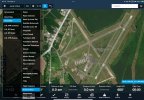
Finally, learning to master you EFB pays dividends in most cases. On the Airport page for your destination, click the Runways tab. If the airport has a an ATIS, then it will show a “best runway” indicator as well as wind direction arrows and headwind/crosswind wind speed numbers for each runway. Feels like cheating. IMG_0921.jpeg

I frequently chart on ForeFlight with the Maps page displayed and the Surface Winds tab turned on. That way at a glance I can see the landing situation at airports in the area. Zoom in on an airport and the wind direction and speed barb are displayed over the runway diagram. IMG_0922.jpeg

I’ve notice that in flying, like in every other field, there are cognitive aspects some people struggle with. Direction is first among those. We no longer orient ourselves the way we did when I was a kid. That’s okay. There are a lot more things that younger people can do that I can’t.

But 455BU above is correct. Learning the cardinal points and numbers associated with them are an essential part of piloting. In your example, I think most of us recognized that wind from 240 degrees was blowing from 30 degrees left of due West (270 degrees). But there was a time we all had to think about it before it became intuitive.

Draw a wind rose in quadrants & label the cardinals: N is 360, S is 180. East is 90, West is 270. Then draw an arrow about where 240 degrees is. Now draw a course line on the plot. We learn by doing…over and over again. Pick random airports and METARS and plot them out by hand. Eventually, what was once intellectual will become intuitive. It’s part of becoming a pilot.
 
0 or 360 is North
90 is East
180 is South
270 is West

Add a 0 to the DG number or the runway number and you have your heading. Now from this number you have your wind, try to think if the wind is coming from the right or left of where you are, you can see this from the wind sock or your crab angle on approach or take off relative to the runway. On approach at towered airports, say “wind check” and they will tell you the winds. See if you can visualize everything in flight.

When taking off and landing you want to find the number closest to the wind number. I’ll usually opt for the longer runway and always take the crosswind but that’s me.
 
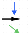
A question to see how deep this is. You are pointed in the direction of the black arrow (heading on the dial of your DG). The wind is strong in the direction of the blue arrow. Are you having trouble realizing your path over the ground will be like the green arrow?

1715255548559.png
 
Last edited:
Hey all,

Admittedly, I'm still struggling with quickly processing degrees and headings along with directions. For example, I'll know that the wind is coming from 240, yet still struggle to understand how it affects my direction or how it relates to the cardinal directions (North, South, East, West). I've experimented with using an INOP VOR gauge in the past to quickly adjust and figure out bearings, headings, and directions, but it can be distracting and not always available in the planes I fly. Another example is quickly being able to decide what runway to land on based on the wind direction from ATIS/AWOS at un-towered airports. I'm not sure why I still struggles with this, but if there is anything anyone suggests to better train my brain I would greatly appreciate it!

Have some open space in your living room or yard? Mark out the cardinal directions in a circle with some books, buckets, sports equipment, whatever, and put the numbers on them 0/360, 90, 180, 270. Then get something that resembles a big enough arrow to represent the wind. Stand in the middle of the arrangement with your arms out and make airplane noises and visualize. Lay out a runway configuration with some folded towels/sheets if necessary.

Change the wind direction and your heading. Change the runway for a different airport. You'll get it in a few sessions.
 
If you have a heading bug on your DG, set the pointer on the wind direction.
I was going to say precisely this. But even if you don’t have a bug, you can look at the numbers and imagine the wind from that angle.
 
Another example is quickly being able to decide what runway to land on based on the wind direction from ATIS/AWOS at un-towered airports. I'm not sure why I still struggles with this, but if there is anything anyone suggests to better train my brain I would greatly appreciate it!

Stop trying to do arithmetic in your head or trying to form mental pictures. Just visualize it using what's already in your cockpit. Does your plane have a directional gyro?

1715264921481.png

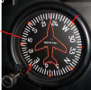
Just look at the DG and see where the wind is and then observe which runway heading is closest to the wind. For example, look at the DG in the pic above. The plane's on a heading of ~227 degrees. Let's suppose you're flying toward an airport with runways 9-27 and the AWOS tells you the wind is 150 degrees. A quick glance at your DG tells you that runway 9 (that is, 90 degrees or due east) is closer to the wind than runway 27 (270 degrees, or due west), so 9 is the preferred runway. It also lets you see that you'll have a crosswind coming from the right when you're on final.

Furthermore, by looking at where the "E" (90 degrees) is on the DG in the picture, you can tell you're roughly on a heading for the 45 degree entry to the downwind. See that little orange arrow in the lower left quadrant? Just put your desired runway heading (90 deg) on that little arrow and you're on the 45. And you didn't have to add or subtract a single number. THIS IS A ROUGH APPROXIMATION AND DOES NOT ACCOUNT FOR CRABBING, but it will get you pretty darned close and you can tweak when you see the airport and runway.

The DG isn't just for maintaining heading. It's also a great tool to picture where the wind is with respect to your heading, and to help you align to runways and to fly correct pattern headings. Learn to make good use of it.
 
Stop trying to do arithmetic in your head or trying to form mental pictures. Just visualize it using what's already in your cockpit. Does your plane have a directional gyro?


Just look at the DG and see where the wind is and then observe which runway heading is closest to the wind. For example, look at the DG in the pic above. The plane's on a heading of ~227 degrees. Let's suppose you're flying toward an airport with runways 9-27 and the AWOS tells you the wind is 150 degrees. A quick glance at your DG tells you that runway 9 (that is, 90 degrees or due east) is closer to the wind than runway 27 (270 degrees, or due west), so 9 is the preferred runway. It also lets you see that you'll have a crosswind coming from the right when you're on final.

Furthermore, by looking at where the "E" (90 degrees) is on the DG in the picture, you can tell you're roughly on a heading for the 45 degree entry to the downwind. See that little orange arrow in the lower left quadrant? Just put your desired runway heading (90 deg) on that little arrow and you're on the 45. And you didn't have to add or subtract a single number. THIS IS A ROUGH APPROXIMATION AND DOES NOT ACCOUNT FOR CRABBING, but it will get you pretty darned close and you can tweak when you see the airport and runway.

The DG isn't just for maintaining heading. It's also a great tool to picture where the wind is with respect to your heading, and to help you align to runways and to fly correct pattern headings. Learn to make good use of it.
You're an engineer. It's way easier for you (and me also) to do what you are saying. But you also got to think like a non-engineer. Some people will NEVER get it that way.
 
Hey all,

Admittedly, I'm still struggling with quickly processing degrees and headings along with directions. For example, I'll know that the wind is coming from 240, yet still struggle to understand how it affects my direction or how it relates to the cardinal directions (North, South, East, West). I've experimented with using an INOP VOR gauge in the past to quickly adjust and figure out bearings, headings, and directions, but it can be distracting and not always available in the planes I fly. Another example is quickly being able to decide what runway to land on based on the wind direction from ATIS/AWOS at un-towered airports. I'm not sure why I still struggles with this, but if there is anything anyone suggests to better train my brain I would greatly appreciate it!
I'm not sure if anyone asked this actual question, but do you struggle with this on the ground doing theoretical problems or just when you're up in the plane flying? During my PPL training, I struggled a bit if we were coming into an airport that I wasn't familiar with and making decisions based on the actual wind and runways while approaching the airport. Meaning, under the workload of actually flying, listening to my instructor blab, writing down the weather, looking up the airport he just gave me to divert to, etc., etc. processing runway choice and how the wind will affect my pattern and landing was difficult. On the ground with a theoretical paper and pencil exercise, I didn't have any issues and could also visualize how it would affect my flight.

If it's just the workload in the airplane, I will only say it gets better with experience/reps. I always plan my destination on my kneeboard scratch pad before I take off based on current weather and 9 times out of 10 it's the same when I get there, including which direction I'll be approaching, how I'll enter the pattern, what they're likely to assign me if towered, frequencies, TPA, etc. Almost like building my personal VFR approach plate.
 

Just look at the DG and see where the wind is and then observe which runway heading is closest to the wind.

:yeahthat:

Vertical card compass also works same.

If aircraft not so equipped, many portable nav programs have an option for an HSI on screen.

Some also do extended runways in map view. Also very helpful.
 
Back
Top