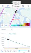
Are you looking at GPS altitude or Mode C pressure altitude (ref 29.92)? Both have different errors that should be accounted for before reaching any conclusions. It's labeled "MSL" which by convention implies pressure altitude, but I don't know where or how it was labeled as such. Any idea of the local altimeter setting at the time of the track?
Nauga,
who asks, "How high is up?"
The data trail is as follows:
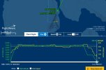
-- the aircraft broadcasts ADS-B Out which includes GPS location, ground speed, GPS altitude, etc.
-- [the aircraft in this case being a recent Cirrus writes to the SD Card a whole bunch more data... e.g. pitch, bank, IAS, altitude MSL, engine data, etc, etc. -- if this SD card survived the fire, there will be a whole bunch of answers there.]
-- ground stations run by private citizens have receivers that (if close enough nearby the aircraft) receive the ADS-B Out data and relay it to the three primary posting web sites (FlightAware, FlightRadar24, and ADSBExchange)... this is where we as observers get to review the ADS-B data... limited to GPS location, ground speed, GPS altitude, etc.
You're correct... although the tracking web sites might label it as MSL, ADS-B data is in fact GPS altitude. In this case, the display tool FlySto does label it as MSL (a bit erroneously) because FlySto also reads the full SD Card data.
Here were the METARs (altimeters ~30.0):
1) METARs:
METAR KBHB 251530Z AUTO 15005KT 1 1/2SM -RA BR OVC003 17/17 A3001 RMK AO2 P0009
METAR KBHB 251539Z AUTO 16004KT 3SM -RA BR OVC003 17/17 A3001 RMK AO2 P0009
METAR KBHB 251556Z AUTO 16008KT 1 1/2SM -RA BR OVC003 17/17 A3000 RMK AO2 SLP161 P0010 T01720172
METAR KBHB 251656Z AUTO 14004KT 1 1/2SM -RA BR OVC003 17/17 A2998 RMK AO2 SLP153 P0000 T01720172
Wayne

 www.wabi.tv
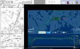
Appears to be:
www.wabi.tv
Appears to be: . There is some terrain NE which makes me....well consider carefully if I'm goign in , on that one, at mins.