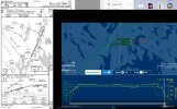
SR-22 Down at Bar Harbor

Weather was right at minimums for ILS 22 - METAR KBHB 251556Z AUTO 16008KT 1 1/2SM -RA BR OVC003 17/17 A3000 RMK AO2 SLP161 P0010 T01720172
 
Seems like a stabilized approach... however, at 5nm out on the ILS 22 (assumption) they should have been at 2100' MSL, rather than ~1000' GPS altitude.
sr22-low.jpeg
 
I spoke with a non-pilot on the scene. He stated he witnessed the Cirrus descend out of clouds, "inverted" on north end of runway. Almost the same area where the then Chief Pilot of Bar Harbor Airways, Peter Monighetti perished in a 402B along with the President & VP of Bar Harbor Airways (Caruso bros.) in similar weather conditions in May 1978. That bare last mile is tough in the fog.
 
Seems like a stabilized approach... however, at 5nm out on the ILS 22 (assumption) they should have been at 2100' MSL, rather than ~1000' GPS altitude.
View attachment 131780
Hmm, I’m reading the tabular data from Flightaware and it says the aircraft was at 2,200, then 2,000 on successive pings at N44.56 W68.29 and N44.55 W68.30, respectively. The FAF, CDLAC is at N44.55 W68.30, 6.1NM from the threshold, so I’m not seeing the same discrepancy you are.

Where are you seeing that they were at 1000’ at CDLAC? I see that he was at 1000’ much closer to the threshold, at just under 3NM.

The data from Flightradar24 and ADS-B exchange are either noisy or incomplete, so I can’t really get much there, though FR24 seems to also show they were at around 2100 at CDLAC.
 
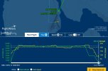
@Flying Keys, I took the FlightAware track into FlySto.net and looked at the descent on the final approach course.

Here's a link to the interactive FlySto graphics. I got ~5 miles out by scaling up the visible runway length of 5200'.
And below a screenshot:
View attachment 131804
Ok, I don’t see a distance scale, but I measured it using Google Earth and that point is about 2.9 nautical miles from the approach end of the runway.

Figuring the GS antenna is about 900’ down the runway, he’s only about 30’ off there, well within the ADS-B margin of error.
 
@Flying Keys, I took the FlightAware track into FlySto.net and looked at the descent on the final approach course.
Are you looking at GPS altitude or Mode C pressure altitude (ref 29.92)? Both have different errors that should be accounted for before reaching any conclusions. It's labeled "MSL" which by convention implies pressure altitude, but I don't know where or how it was labeled as such. Any idea of the local altimeter setting at the time of the track?

Nauga,
who asks, "How high is up?"
The data trail is as follows:
-- the aircraft broadcasts ADS-B Out which includes GPS location, ground speed, GPS altitude, etc.
-- [the aircraft in this case being a recent Cirrus writes to the SD Card a whole bunch more data... e.g. pitch, bank, IAS, altitude MSL, engine data, etc, etc. -- if this SD card survived the fire, there will be a whole bunch of answers there.]
-- ground stations run by private citizens have receivers that (if close enough nearby the aircraft) receive the ADS-B Out data and relay it to the three primary posting web sites (FlightAware, FlightRadar24, and ADSBExchange)... this is where we as observers get to review the ADS-B data... limited to GPS location, ground speed, GPS altitude, etc.

You're correct... although the tracking web sites might label it as MSL, ADS-B data is in fact GPS altitude. In this case, the display tool FlySto does label it as MSL (a bit erroneously) because FlySto also reads the full SD Card data.

Here were the METARs (altimeters ~30.0):
1) METARs:
METAR KBHB 251530Z AUTO 15005KT 1 1/2SM -RA BR OVC003 17/17 A3001 RMK AO2 P0009
METAR KBHB 251539Z AUTO 16004KT 3SM -RA BR OVC003 17/17 A3001 RMK AO2 P0009
METAR KBHB 251556Z AUTO 16008KT 1 1/2SM -RA BR OVC003 17/17 A3000 RMK AO2 SLP161 P0010 T01720172
METAR KBHB 251656Z AUTO 14004KT 1 1/2SM -RA BR OVC003 17/17 A2998 RMK AO2 SLP153 P0000 T01720172

Wayne
 
...although the tracking web sites might label it as MSL, ADS-B data is in fact GPS altitude. In this case, the display tool FlySto does label it as MSL (a bit erroneously) because FlySto also reads the full SD Card data.
ADS-B reports both pressure altitude and GPS altitude. The question is, which one is your tool using and how has it been corrected, if at all?
Where did the SD card data you refer to come from in this instance?

Nauga,
from where a miss is as good as a mile
 
Hi everyone.
Another terrible accident and we are likely that we will never find out exactly what happened.
Looking at the data there are no data points that would would point to anything way out of normal during the approach, assuming this was the intended rwy.
Looking at the plate and comparing ground references, I cannot find anything out of normal.
The last data point may indicate a slow speed for the 22 but nothing else that I can find.
I have many more data points in case anyone is interested.
Very sad.
 

Attachments

  • 990PT-CDLAC.jpg
    990PT-CDLAC.jpg
    403.8 KB · Views: 5
  • 990PT-FinalData.jpg
    990PT-FinalData.jpg
    117.9 KB · Views: 6
@nauga, I have to admit I don't know which (pressure altitude or GPS altitude) the ADS-B tracking sites (FlightAware, FlightRadar24, ADSBExchange) are using. The track display site FlySto.net in this case got a kml file output from FlightAware, so again I don't know which altitude FlightAware exported to that kml file.

The SD Card data in the panel system (Perspective+ = ~G1000) is of course in the physical panel of the crashed aircraft. I would expect it may well have been destroyed in the resulting fire. If it survived we'll likely get info from that (after 2 years) in the NTSB final report.
 
Back
Top